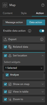
Idea: Allow app developers to specify which layers will have the "Set Location" data action available to users rather than make it a choice between adding it to all layers or none in the Map action panel.
Reason: I maintain several apps that use the Near Me widget (which I have renamed Analyze in my app). All of these apps include dozens of layers, but users would only ever want to use the features from two of them (project boundaries and parcels) as inputs for the Near Me widget. I would like them to be able to click on a parcel or project boundary and then click "Set Location" to use that boundary as their analysis unit. However, I can only select the widgets the Set Location action will apply to; I can't specify which layers it should appear on.

If a user unwittingly clicks Set Location on a huge polygon in another layer (e.g. a county or national forest), it will trigger an analysis that will take eons to complete, and they'll probably end up having to refresh their tab to get out of it. Note that this issue could be mitigated by this other closely related idea.

On a related note, it would be great if we could customize the action text, since our users typically have no idea what "Set Location" will do until they've been trained. I realize that's a separate idea.