Select to view content in your preferred language

What’s new in Near Me (February 2025)

2177
29
02-25-2025 12:56 PM
Labels (2)
AzizaParveen1
Esri Contributor
5 29 2,177

New features added in Near Me for February 2025 release.

New functionalities:

  • Added support for data view

Web AppBuilder functional parity

Export to PDF:

We added Export to PDF functionality in Near Me this release.  This functionality is similar to Report functionality we have in Web AppBuilder Screening and Situation Awareness widget.

        If export is allowed in your layer, you should be able see this option at the Batch Export level.

If you do not need customized layout, advanced reporting capabilities and/ or want better performance exporting to a .pdf file is the simplest way to generate report with Near Me result data. The file will include title, map, legend and Near Me analysis results. You will be able to add a custom title and choose print layout.

If sorting and export fields are configured, the functionality will reflect those settings in the report.
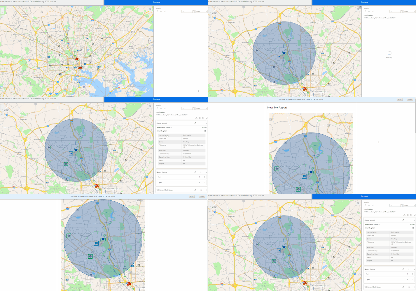
NearMe_exporToPDF_final.gif

Save:

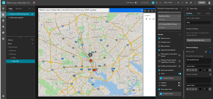
Another major enhancement we worked on this release is, Save functionality. Users now can save input location (drawn graphics, searched or selected feature that is being used as input location in the analysis) and search area when target layers are configured. The configuration option is added to the Results section. At runtime, Save button will appear at the top menu bar along with Export, Clear and Refresh button.

Clicking on the Save button will open corresponding layer’s feature form. The Feature forms can be        configured to show selected fields in the Map Viewer. It will honor all the settings of the forms.
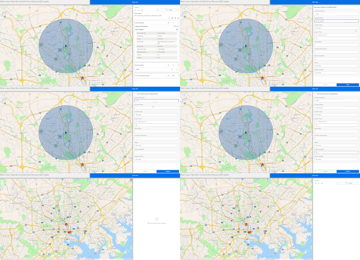
NearMe_savefeatures.gif

AzizaParveen1_1-1740516793454.png


29 Comments
SteveCole
Honored Contributor

The following from your post is confusing:

If you do not need customized layout, advanced reporting capabilities and/ or want better performance exporting to a .pdf file is the simplest way to generate report with Near Me result data. The file will include title, map, legend and Near Me analysis results. You will be able to add a custom template and choose print layout.

This seems to imply that the use of a report template is not required however the help doc for the Near Me widget suggests otherwise. Can you print to pdf the results of the Near Me widget *without* the use of a report template? How is this then accomplished?

I am fine with the popup template information that is returned in the Near Me results but just want to save it as a PDF. Going through the extra work of having to create a report template is excessive IMO.

Steve

AzizaParveen1
Esri Contributor

@SteveCole I am really sorry, it was a typo, it should be title, you will not need any reporting template or any extra work from your part.

I just corrected it, my apology again.

SteveCole
Honored Contributor

@AzizaParveen1  The question still stands- how does one export the result to PDF. I do not see an option under the export command with the results:

exportNearMeResults.jpg

AzizaParveen1
Esri Contributor

@SteveCole , The feature is scheduled to release tonight. You should be able to see it after it is released. 

SteveCole
Honored Contributor

Gotcha, thanks for clarifying that.

AzizaParveen1
Esri Contributor

@SteveCole Thank you for your questions, I should have scheduled publishing it after release🙂

SteveCole
Honored Contributor

So the print to PDF feature has rolled out and it's........extremely disappointing. It's basically a clipped output version of export to CSV. This is *not* what I was expecting. This really adds nothing beneficial compared to Export to CSV.

What I had expected the PDF export functionality was to offer was that what the Near Me Widget returns as results:

nearMeReport_screen_results.jpg

Essentially, the results posted on screen would be captured in a PDF. It's all HTML elements that EB has already generated so why is it so difficult to just dump that into a new browser HTML for the print to PDF? I've already done this in the 3.x JS API application I'm trying to get off of.

Looks like I'm never going to be able to get off my JS API application..

AnthonyJonesRSK
Frequent Contributor

Hi @AzizaParveen1,

Thanks for the update it's great to see the report functionality added but we were also a bit disappointed to see that a lot of functionality available in Web AppBuilder didn't make it over. Below are some of the things we spotted that are missing from near me tool report that were in the screening tool. Do you know if these are still in the road map?

  • Scale bar
  • North arrow 
  • Map attribution/copyright statement
  • Option to add or change time/date/area size/comments
  • Ability to choose which fields are exported - always exports all of them

We also noticed that the report only shows points data and related tables are not included. Is this something that could be added in a future update?

To get around this we tried getting our tables into the report by creating a joined view for each with the parent point layer. We found when using this method though that there appears to be a bug with domains. For our joined views they appear in the report but for any field using a domain the report only shows the domain code and not the label. Please see below for an example. Fields such as vehicle type only display the code so is not much use in the report. We tested with a regular view too, which worked, so this appears to be specific to join views.

AnthonyJonesRSK_0-1741093027004.png

Could this be looked into please as we are very keen to move one of our apps from Web AppBuilder given its retirement next year but this is preventing us being able to roll out our experience builder version.

Thanks

Anthony

AzizaParveen1
Esri Contributor

Hi @AnthonyJonesRSK ,

Yes, they are on the road map, we are working on this. Hopefully we will be able add this in next update. Choosing which fields to be exported is already available, it works with Configure fields to export setting in the configuration of Edit Analysis panel. We do not have any plan for related table at this moment, But I will look into the domain bug you are seeing. Thank you.

AzizaParveen1_4-1741279831001.png

AzizaParveen1_2-1741279790842.png


AzizaParveen1
Esri Contributor

Hi @SteveCole,

I am sorry to hear that, most users requested the tabular format and this is what we had in Screening and Situation Awareness widget, so this added the functional parity in Experience Builder. Another major issue with pop-up approach is, Near Me supports different workflows like map area search, and show all features search, there can be large number of features (hundreds of thousands) in those cases printing pop-ups do not make much sense. In your case, you can use Nearby Instant App, that has the similar Export to PDF functionality you are looking for.

Thanks,

Aziza

AnthonyJonesRSK
Frequent Contributor

Hi @AzizaParveen1,

Thanks for the response on this that's really good to hear. 

On selecting the fields to be included in the report sorry I was referring to the ability to do this at runtime. This functionality was available in the screening tool so it would be great if it could be brought to the near me tool too.

AnthonyJonesRSK_0-1741339471819.png

Thank you for looking into the potential bug that's much appreciated. Including related tables would be a great addition too as in our case we have an accident dataset that has two related tables and the only way we can get them into the near me tool is by converting them to points. We then have 3 points for each accident and it also consumes additional space and credits in our portal. If the tool could recognise each related record for each point within the search area that would be great. The joined views were an attempt to get around the storage issue but the domain problem is stopping us from rolling it out.

Thanks again for your response.

Anthony 

SteveCole
Honored Contributor

@AzizaParveen1  Instant apps are narrowly focused in functionality so it's really isn't an option for my use case.

I'm really mystified why ESRI would choose to develop an experience that returns information to the user one way (results on screen, formatted as pop up content) and then completely change it when the user wants to preserve that information (print to PDF as spreadsheet content). You already have an export to CSV option so the Print to PDF option you have rolled out is duplicative of Export to CSV *and* it clips the output so who really finds that useful?

This makes no sense at all.

NateRenn
Occasional Contributor

There appear to be a few issues with the export to PDF option. First how do you change the field names in the output? This was an option in the screening widget, but nothing I have tried has fixed it yet in the Near Me widget, I thought configuring field aliases in the web map would work but it does not. 

Fieldaliases.jpg

The other issue I am seeing is that when I test the export from my office it will display all of the layers I want to see in the export, but when I try the same app in an incognito tab it will only display one of the layers and not the rest. All layers are public.

Showing all layers here:

Alllayers.jpg

Missing layers in the incognito tab, same location:

missinglayers.jpg

Here is my configuration in ExB. Even with feature count toggled it still returns it in the export.

setup.jpg

AzizaParveen1
Esri Contributor

Hi @NateRenn ,

I cannot reproduce your first issue , in the screenshot below, these are all aliases. Near Me honor field aliases from the feature layer. Could you please go to your feature layer item detail page ->Click on Data tab ->Click On Field and make sure you have aliases for these fields? if not you can change aliases there. I will check your 3rd issue seems like a bug to me, and I am not sure of the 2nd issue, I will check and get back.


AzizaParveen1_1-1742602531256.png

AzizaParveen1_2-1742602586973.png


NateRenn
Occasional Contributor

Thanks @AzizaParveen1 I was able to change the aliases. I still am having trouble with the Near me widget returning all the layers in incognito. Some have even had the issue in non-incognito tab. Here is the link to the application https://experience.arcgis.com/experience/c35f5fe6d6a54b388cd177f66084e39c The only thing unique about this app is that the main parcel layer is a secured layer in AGO, and can only be viewed in this app and webmap.

AzizaParveen1
Esri Contributor

@NateRenn thank you for the update and sharing your app. Looks like your Supervisor Districts and County zoning layers do not have export enabled at the service level, these layers do not show the Export button for me at the layer level (batch export button on top will show when there is at least one layer with export enabled capability). Here is the tricky part, if you are the owner of these layers you will see the Export button and should be able to export it, but others will not. This is what I see, 

AzizaParveen1_1-1742841169442.png


You can find and enable this setting in  feature item detail page -> Settings ->

AzizaParveen1_0-1742840825906.png

Could you please enable this setting and see it works as expected or not? Please ask your coworkers to check this for you if you are the owner of these two layers.

NateRenn
Occasional Contributor

@AzizaParveen1 thank you! That worked, I am seeing all the layers in an incognito tab and others are seeing it as well now.

One more issue we seem to be having is if you enable proximity search in the Results section when setting up the Near Me Widget. It will return the analysis for your initial selection in the map (by selecting a parcel and then hitting the Near Me Widget icon or using the selection tool), but after you clear the selection and the analysis it will never give you a result again until you refresh the browser.

selection1.jpgselection2.jpg

Thank you for all of your help! We have been waiting for this functionality for some time.

AzizaParveen1
Esri Contributor

Hi @NateRenn,

I am not sure I clearly understand your workflow. Could you please share the video of your workflow? When you enable Proximity search it will let you select a specific feature from the Near Me results and use that result as input location for Near Me analysis. So when this is enabled , you will see "Set location" option from the from Data action menu, now if you click on Set location it will use this feature as input location and run the analysis again, you don't need to clear the results for this.

AzizaParveen1_0-1742851660786.png


NateRenn
Occasional Contributor

@AzizaParveen1 thanks, I guess I was confused about the functionality and did not see that option. I have attached a video of how I was thinking it would function. I select a parcel and then open the Report Widget and it will run the analysis, but only that one time as you see me select another. When I refresh the browser it does work again for that first selection.

AzizaParveen1
Esri Contributor

@NateRenn I see the issue. You have the Near Me widget in widget Controller right? Add another message action to the map widget -> Record selection change-> Widget Controller ->Open widget -> Near Me

Your Map widget message action will look like the following screenshot.

With this set up, you don't have click on your Report widget, when you select a record, it will open Near Me widget and run the analysis.

AzizaParveen1_1-1743107446967.png

Hope this helps,

Aziza

AnthonyJonesRSK
Frequent Contributor

Hi @AzizaParveen1 ,

Just wondering if you'd had chance to look into the domain bug when using joined views?

Thanks

Anthony

NateRenn
Occasional Contributor

Thanks @AzizaParveen1 that worked I removed the "open Widget" part of the action so that they can just select and then open the report if they need it. Thanks for your help this works well for our needs!

AzizaParveen1
Esri Contributor

@AnthonyJonesRSK So sorry, I didn't have a chance to create a joined view, is it possible for you to share your web map and app with me? It will really helpful for us to track the issue down quickly this way.

AnthonyJonesRSK
Frequent Contributor

@AzizaParveen1 Thanks for the super quick reply. I'm just about to finish up for the day but will come back to you Monday if that's ok and see if I can share the app with you in a group. My colleague was working on it and not sure if they've since removed the joined views so will check with them and get something that you can look at. Thanks and have a good weekend.

AzizaParveen1
Esri Contributor

Monday works for me @AnthonyJonesRSK . You have a great weekend as well.

GISFunctionalGroup
Regular Contributor

@AzizaParveen1 Hi, 
We are using the same Near Me widget with 1.17 ESRI Dev version. In this widget, WE are not able to use the "Custom Print template" in the export options. We are using the map services in the widget. we are having following 2 queries.

Can we use the custom print template in this version of the widget or not ??
For the fields in the export PDF options how can we rename (alias) of the fields for the table?

Your assistance is highly appreciated.


Regards

GIS Functional group 


JoeWard
Emerging Contributor

Is this available for Enterprise 11.3?   

AzizaParveen1
Esri Contributor

@GISFunctionalGroup ,

You should be able to use custom print template if you are using Enterprise print service. You will need Enterprise portal not stand alone server for this to work and I believe it is supported from 11.3.

Are you using map service as source of your report? if yes, then you need to add your layers as feature layer like this https://sampleserver6.arcgisonline.com/arcgis/rest/services/USA/MapServer/0 in the map, you cannot use https://sampleserver6.arcgisonline.com/arcgis/rest/services/USA/MapServer url.

For field alias change , please go to your feature layer item detail page ->Click on Data tab ->Click On Field and change aliases

AzizaParveen1_0-1743450812728.png


AzizaParveen1
Esri Contributor

@JoeWard no, Export to PDF option will be in 11.5.