- Home
- :
- All Communities
- :
- Products
- :
- ArcGIS Enterprise
- :
- ArcGIS Enterprise Questions
- :
- Re: Problem with viewing orthophoto published with...
- Subscribe to RSS Feed
- Mark Topic as New
- Mark Topic as Read
- Float this Topic for Current User
- Bookmark
- Subscribe
- Mute
- Printer Friendly Page
Problem with viewing orthophoto published with ArcGIS Server
- Mark as New
- Bookmark
- Subscribe
- Mute
- Subscribe to RSS Feed
- Permalink
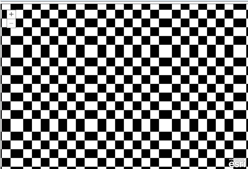
I’ve published an orthophoto via ArcGIS Server, but after viewing the service, I figured out that there is a problem with viewing the service at large scales; when zooming in, the orthophoto disappears and the map becomes full of black\white squares (in the screenshot below). What might be the problem here?
Thank you and Kind Regards,
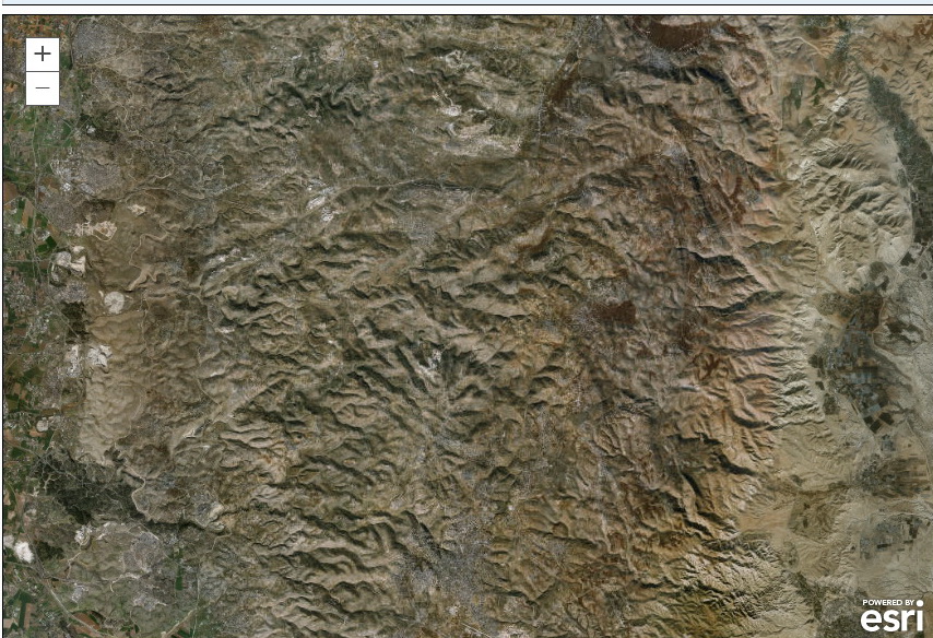
1- At small scale
2- when zooming in to larger scale, everything disappears, and I get this:
- Mark as New
- Bookmark
- Subscribe
- Mute
- Subscribe to RSS Feed
- Permalink
At what scale is the issue arising? If you have created tiled cache, check what is the scale of your highest level cache?
Think Location
- Mark as New
- Bookmark
- Subscribe
- Mute
- Subscribe to RSS Feed
- Permalink
It would also be helpful to know what version of ArcGIS Server you are using, and it was cached at the same version (if not, what version was used). Did you use the normal "expanded" cache or the bundles (note: bundles in 10.1 vs 10.2 vs 10.3 are all different). If expanded, you can go to the folder containing the cache, look at the scale level and see if the cached image is correct/exists.
What was your source for tiles (e.g. tif).? Did you use a mosaic dataset with Image Server extension?
I have seen this issue before, and typically it was because I was trying to cache a cache (was able to do this in 9.x or 10.0 for older datasets I was trying to reproject....don't try this at home  ). It could also be caused by running out of temp space (C: drive) when running your cache process.
Or to add to what Jayanta mentioned, it could be trying to zoom into a scale that maybe valid for the service, but you have "cache-on-demand" turned off, or turned on and the client handled it incorrectly.
What client are you seeing this with? ArcMap, ArcCatalog, or a web app (and which API/type)?
Sorry for all the questions, but sometimes more info is needed to know the cause (so many variations out there).
- Mark as New
- Bookmark
- Subscribe
- Mute
- Subscribe to RSS Feed
- Permalink
Rebecca:
You state "note: bundles in 10.1 vs 10.2 vs 10.3 are all different".
Does this mean that a bundled cache created in 10.2 should be re-created in 10.3 in order for it to work properly? I ask because I was not planning to re-create all my bundled 10.2 services in 10.3.
- Mark as New
- Bookmark
- Subscribe
- Mute
- Subscribe to RSS Feed
- Permalink
No, if it's created in 10.2 it will work in 10.3 without issue.
The 10.3 bundle is even more compact, and the issue I have with that is when sharing the cache files direct with other ArcMap users. I have remote users that can't access the services. For these users, I can send them a copy of the cache folder on a drive, and using ArcMap/Catalog, they can use the cache direct. This was a "feature" starting in 9.3 or 10.x I think. The issue I've found with that is that 10.2 users can not directly view the 10.3 bundle folders.
- Mark as New
- Bookmark
- Subscribe
- Mute
- Subscribe to RSS Feed
- Permalink
Many thanks for the valuable input Rebecca,
Actually, I’ve set the caching configuration, but I did not started caching yet, because it takes a lot of time, I should highlighted this in my post! Sorry for inconvenience
Regarding the other details, kindly find them below:
Version: 10.3.1
Source tile format: ECW
Mosaic + Image Server Extension: Yes
Cache on demand: Enabled
Client: ArcMap, ArcGIS viewer for Javascript (the problem arises on both)
Thank you again!
- Mark as New
- Bookmark
- Subscribe
- Mute
- Subscribe to RSS Feed
- Permalink
Thanks for interest Janayka,
The problem appears at scale 1:24000,
I have not cached the orthophoto yet, I should mentioned this!
- Mark as New
- Bookmark
- Subscribe
- Mute
- Subscribe to RSS Feed
- Permalink
Hi Hani,
This issue usually occurs when the source imagery cannot be accessed. When you load rasters into the mosaic dataset, make sure you are using a UNC path.
What is happening is that the ArcGIS Server instance is accessing the mosaic dataset. At small scales, the overviews are returned. When you zoom to a large scale, the raw imagery is returned. If ArcGIS Server is installed on a different machine than the mosaic dataset, the service looks for the imagery according to the path of the rasters (i.e. C:\data\rasters). If you load the rasters with a UNC path, the ArcGIS Server instance knows which machine to find the rasters (i.e. \\rasterserver\data\rasters).
- Mark as New
- Bookmark
- Subscribe
- Mute
- Subscribe to RSS Feed
- Permalink
Many thank Jake for the prompt contribution,
Actually, the source data is stored locally on the same machine the ArcGIS Server is installed
Best,
- Mark as New
- Bookmark
- Subscribe
- Mute
- Subscribe to RSS Feed
- Permalink
Also, make sure the ArcGIS Server Account (i.e. arcgis) has read privileges to the rasters.