- Home
- :
- All Communities
- :
- Products
- :
- ArcGIS Enterprise
- :
- ArcGIS Enterprise Questions
- :
- Re: How to determine which map services are using ...
- Subscribe to RSS Feed
- Mark Topic as New
- Mark Topic as Read
- Float this Topic for Current User
- Bookmark
- Subscribe
- Mute
- Printer Friendly Page
How to determine which map services are using a specific data store?
- Mark as New
- Bookmark
- Subscribe
- Mute
- Subscribe to RSS Feed
- Permalink
We're trying to track down the map services that are using a specific data store. It seems the closest I can get to that information is with the ArcGIS Data Store command utility's describedatastore (ArcGIS Data Store command utility reference—ArcGIS Data Store (Windows) Installation Guide | ArcGIS ...) command which is limited to the number of current feature layer connections and nothing more. Is it possible to get these details some other way?
Solved! Go to Solution.
Accepted Solutions
- Mark as New
- Bookmark
- Subscribe
- Mute
- Subscribe to RSS Feed
- Permalink
If you really want REST API based solution, there is a manifest.json end-point for each map service. e.g.
This gives you details of database/FGDB connections and layers for each. e.g.
{
"databases": [
{
"byReference": true,
"onServerWorkspaceFactoryProgID": "esriDataSourcesGDB.SdeWorkspaceFactory",
"onServerConnectionString": "ENCRYPTED_PASSWORD=3345435we23232543546456567;SERVER=DBSERVER;INSTANCE=sde:sqlserver:DBSERVER;DBCLIENT=sqlserver;DB_CONNECTION_PROPERTIES=DBSERVER;DATABASE=TESTDB;USER=dbadmin;AUTHENTICATION_MODE=DBMS;BRANCH=sde.DEFAULT",
"onPremiseConnectionString": "ENCRYPTED_PASSWORD=3345435we23232543546456567;SERVER=DBSERVER;INSTANCE=sde:sqlserver:DBSERVER;DBCLIENT=sqlserver;DB_CONNECTION_PROPERTIES=DBSERVER;DATABASE=TESTDB;USER=dbadmin;AUTHENTICATION_MODE=DBMS;BRANCH=sde.DEFAULT",
"onServerName": "sde.DEFAULT (DBSERVER)",
"onPremisePath": "",
"datasets": [
{
"onServerName": "ServiceTerritory"
},
{
"onServerName": "StructureBoundary"
},
{
"onServerName": "WaterDevice"
},
{
"onServerName": "StructureLine"
},
{
"onServerName": "WaterJunction"
},
{
"onServerName": "WaterAssembly"
},
{
"onServerName": "StructureJunction"
},
{
"onServerName": "WaterLine"
},
{
"onServerName": "WaterSubnetLine"
},
{
"onServerName": "WaterDistribution"
},
{
"onServerName": "HydrantMaintenanceInspection"
},
{
"onServerName": "ValveInspection"
}
]
}
],
"resources": [
{
"onPremisePath": "D:\\TEST\\General\\UtilityNetwork\\WaterNetwork\\V2.4\\WaterDistributionUtilityNetwork.aprx",
"clientName": "DBSERVER",
"serverPath": "D:\\AGSEnterprise\\Server\\directories\\arcgissystem\\arcgisinput\\UN\\NapervilleWater.MapServer\\extracted\\p20\\NapervilleWater.msd"
}
]
}
- Mark as New
- Bookmark
- Subscribe
- Mute
- Subscribe to RSS Feed
- Permalink
Hi Durham GIS
Log in to your ArcGIS Server Admin page as an adminstrator:
https://machinename/arcgis/admin
under services > Hosted, navigate to the service of interest.
e.g.
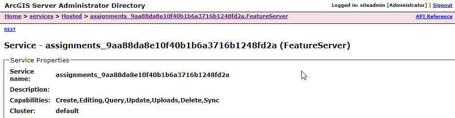
If you click on the edit button at the bottom:
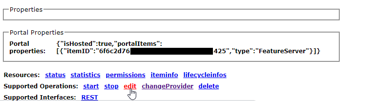
In the JSON, under database > datasource, you should see something like AGSDatastore_ds_xxxxxx

Take note of the above mentioned datastore "id".
Now go into data > items > enterpriseDatabases > <datastore id> and click on edit.
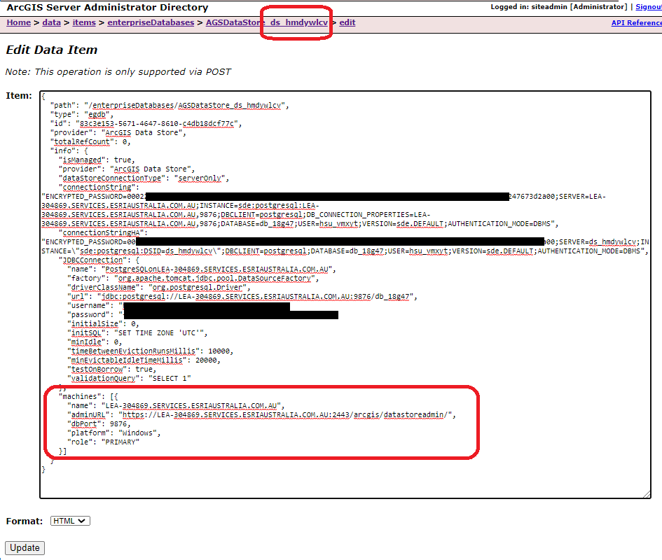
In the JSON, under machines, you should be able to see where the datastore was installed. The service would reside on this datastore on this machine.
Hope that helps.
Regards,
Derrick
- Mark as New
- Bookmark
- Subscribe
- Mute
- Subscribe to RSS Feed
- Permalink
Thanks Derrick, I really appreciate the guidance and screen grabs. I checked some hosted FeatureServer services and can see the datastore information but this information doesn't seem to be available for MapServer services.
- Mark as New
- Bookmark
- Subscribe
- Mute
- Subscribe to RSS Feed
- Permalink
This may be worthwhile to wait and verify from Derrick, however I don't believe Map Services are stored in your ArcGIS Data Store. Hosted content is stored in the ArcGIS Data Store, i.e. Hosted Feature Layers, outputs from Portal Analysis Tools, etc.
Here is some information on Data Store: What is ArcGIS Data Store?—ArcGIS Data Store (Windows) Installation Guide | Documentation for ArcGIS...
When it comes to Map Services, either you're copying the data directly to ArcGIS Server or you're going to be using a registered connection. If using the registered connection, Server will read the Map Service based on what's being referenced via the source database.
The above workflow seems to be applicable to only Hosted layers.
Best,
Joe
- Mark as New
- Bookmark
- Subscribe
- Mute
- Subscribe to RSS Feed
- Permalink
My interest is in the registered data store details. We have several of them with some possible duplication based on the name that was given during the registration process. We didn't want to unregister any data stores without knowing what services are using them.
- Mark as New
- Bookmark
- Subscribe
- Mute
- Subscribe to RSS Feed
- Permalink
I also wish there were a way to rename a registered data store! Publishers have found it very easy to register a enterprise database when publishing but they don't follow our agency's naming scheme. Most publisher register data stores have very vague name and many don't distinguish between dev, test and prod data sources.
- Mark as New
- Bookmark
- Subscribe
- Mute
- Subscribe to RSS Feed
- Permalink
Hi Joe Catanzarita
You are correct, the relational datastore stores the Portal's hosted feature layer data. When Durham GIS mentioned ArcGIS DS, i assumed he meant the hosted feature services.
Durham GIS, if you were referring to the services published from your Enterprise GeoDatabase, you can navigate to:
...\arcgisserver\directories\arcgissystem\arcgisinput\XXX\extracted\v101 where XXX is the map service name.
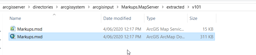
The folder will match the structure in the ArcGIS Server REST endpoint:

The mxd (if published via ArcMap) will tell you where the source data resides..
Hopefully, that's what you are looking for.
Regards,
Derrick
- Mark as New
- Bookmark
- Subscribe
- Mute
- Subscribe to RSS Feed
- Permalink
That is helpful to know but I was hoping for a REST API solution if possible in order to automate.
- Mark as New
- Bookmark
- Subscribe
- Mute
- Subscribe to RSS Feed
- Permalink
Hi Durham GIS
There isn't one that I am aware of unfortunately. You can however automate it using python/java/C# and their respective ArcGIS API; Have your script loop through the root folder and read each mxd and generate a report for you.
Hope that helps.
Derrick
If this answer was helpful please mark it as helpful. If this answer solved your question please mark it as the answer to help others who have the same question.
- Mark as New
- Bookmark
- Subscribe
- Mute
- Subscribe to RSS Feed
- Permalink
If you really want REST API based solution, there is a manifest.json end-point for each map service. e.g.
This gives you details of database/FGDB connections and layers for each. e.g.
{
"databases": [
{
"byReference": true,
"onServerWorkspaceFactoryProgID": "esriDataSourcesGDB.SdeWorkspaceFactory",
"onServerConnectionString": "ENCRYPTED_PASSWORD=3345435we23232543546456567;SERVER=DBSERVER;INSTANCE=sde:sqlserver:DBSERVER;DBCLIENT=sqlserver;DB_CONNECTION_PROPERTIES=DBSERVER;DATABASE=TESTDB;USER=dbadmin;AUTHENTICATION_MODE=DBMS;BRANCH=sde.DEFAULT",
"onPremiseConnectionString": "ENCRYPTED_PASSWORD=3345435we23232543546456567;SERVER=DBSERVER;INSTANCE=sde:sqlserver:DBSERVER;DBCLIENT=sqlserver;DB_CONNECTION_PROPERTIES=DBSERVER;DATABASE=TESTDB;USER=dbadmin;AUTHENTICATION_MODE=DBMS;BRANCH=sde.DEFAULT",
"onServerName": "sde.DEFAULT (DBSERVER)",
"onPremisePath": "",
"datasets": [
{
"onServerName": "ServiceTerritory"
},
{
"onServerName": "StructureBoundary"
},
{
"onServerName": "WaterDevice"
},
{
"onServerName": "StructureLine"
},
{
"onServerName": "WaterJunction"
},
{
"onServerName": "WaterAssembly"
},
{
"onServerName": "StructureJunction"
},
{
"onServerName": "WaterLine"
},
{
"onServerName": "WaterSubnetLine"
},
{
"onServerName": "WaterDistribution"
},
{
"onServerName": "HydrantMaintenanceInspection"
},
{
"onServerName": "ValveInspection"
}
]
}
],
"resources": [
{
"onPremisePath": "D:\\TEST\\General\\UtilityNetwork\\WaterNetwork\\V2.4\\WaterDistributionUtilityNetwork.aprx",
"clientName": "DBSERVER",
"serverPath": "D:\\AGSEnterprise\\Server\\directories\\arcgissystem\\arcgisinput\\UN\\NapervilleWater.MapServer\\extracted\\p20\\NapervilleWater.msd"
}
]
}