- Home
- :
- All Communities
- :
- Products
- :
- ArcGIS Enterprise
- :
- ArcGIS Enterprise Questions
- :
- Re: Extract Features From MapServer/ Rest/ Soap/ e...
- Subscribe to RSS Feed
- Mark Topic as New
- Mark Topic as Read
- Float this Topic for Current User
- Bookmark
- Subscribe
- Mute
- Printer Friendly Page
Extract Features From MapServer/ Rest/ Soap/ etc?
- Mark as New
- Bookmark
- Subscribe
- Mute
- Subscribe to RSS Feed
- Permalink
Is it possible to extract gis data (features, records, geometry, etc) from arcgis rest/ soap/ Mapservers?
For example: ProxyServices/DDOTBaseMapProxy (MapServer)
can i extract the first layer
- Railroad_1200 (1)
and make it a shapefile/ feature class, etc?
Thanks!
Solved! Go to Solution.
- Mark as New
- Bookmark
- Subscribe
- Mute
- Subscribe to RSS Feed
- Permalink
Yes, you're right, Jake, thanks for the answer. I was hopping to find a way to handle this kind WMS services to download its feature data. Thank you for you attention and time.
- Mark as New
- Bookmark
- Subscribe
- Mute
- Subscribe to RSS Feed
- Permalink
Hi Jake, happy day.
Could you help me on how to handle this kind of errors, please. Maybe a query sentence that i can use.
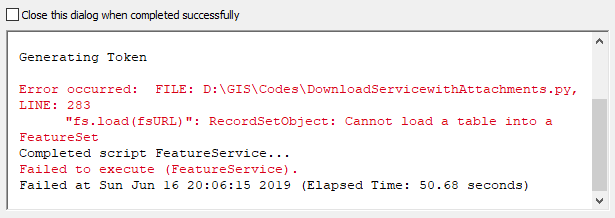
1. This error appeared when i was trying to download this feature layer
http://sinpad.indeci.gob.pe/arcgis/rest/services/SINPAD_2018/MapServer/215
2. This second error appeared when i was trying to download this feature layer
http://sinpad.indeci.gob.pe/arcgis/rest/services/SINPAD_2018/MapServer/204

Thank you for your time and attention.
Regards,
Juan Julio
- Mark as New
- Bookmark
- Subscribe
- Mute
- Subscribe to RSS Feed
- Permalink
Juan Julio Liñan rebaza it looks like this service was published without the SHAPE field enabled, so you won't be able to download the geometry of this service. However, you can download this as a table if that is helpful:
- Mark as New
- Bookmark
- Subscribe
- Mute
- Subscribe to RSS Feed
- Permalink
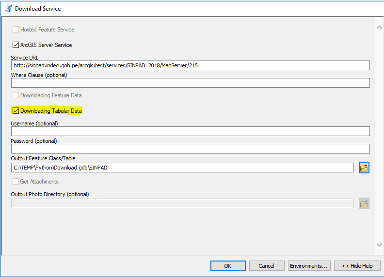
Hi Jake, thank you for your time. Look, when i try to download the tabular data from this feature layer
http://sinpad.indeci.gob.pe/arcgis/rest/services/SINPAD_2018/MapServer/215
i get this error:

On the other side, whe i try to download the feature data from this feature layer, using a query statement
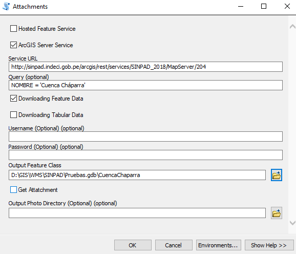
I exported the feature. This means that the shape field is enabled right?

Is there a better way to use query statemets to download only the valid geometries or "downloadable features'?
I was tryng to do the same process with the other feature service but with no succes.


When I try to use the same query on the web to export a KMZ, it is succesfully done.


Is this another probe that the shape field is enabled? Is there a way to export all the fields into a kmz format?
Thank you for your help. I'm tryng with all possibilities.
Regards
Juan julio
- Mark as New
- Bookmark
- Subscribe
- Mute
- Subscribe to RSS Feed
- Permalink
Juan Julio Liñan rebaza looks like KMZ may work. You can specify your query, and specify an * for the Out Fields parameter. This will return all fields.

Once you have the KMZ file, you can use the KMZ To Layer tool to convert the data to a File Geodatabase.
- Mark as New
- Bookmark
- Subscribe
- Mute
- Subscribe to RSS Feed
- Permalink
Thank you Jake, after excecute the tool it generates a layer with all the data in a field called PopopInfo in a XML format. There is a tool or a way to corvert it to a table?

Thank you again. All you have told me has been really helpful.
Regards,
Juan Liñan
- Mark as New
- Bookmark
- Subscribe
- Mute
- Subscribe to RSS Feed
- Permalink
with Python:
the simple way: https://community.esri.com/thread/118781#445348
or using a little more advanced: https://community.esri.com/thread/118781#445572
- Mark as New
- Bookmark
- Subscribe
- Mute
- Subscribe to RSS Feed
- Permalink
can i do it with this dataset?
- Mark as New
- Bookmark
- Subscribe
- Mute
- Subscribe to RSS Feed
- Permalink
Thanks for the update. I cannot get the tool to work for some reason? Do I have to edit the python code? Also, the feature class attribute table shows 77,994 records, but the actual geometry has way less? The attached picture shows in red where the features are (the black is just a admin 1 boundary of indonesia). I dont think the tool actually grabbed all the geometry (unless you stripped out the geometry and just kept empty records for size?)? Please let me know.
Thanks!