- Home
- :
- All Communities
- :
- Products
- :
- ArcGIS Enterprise
- :
- ArcGIS Enterprise Questions
- :
- Re: Cache missing tiles at certain scale
- Subscribe to RSS Feed
- Mark Topic as New
- Mark Topic as Read
- Float this Topic for Current User
- Bookmark
- Subscribe
- Mute
- Printer Friendly Page
- Mark as New
- Bookmark
- Subscribe
- Mute
- Subscribe to RSS Feed
- Permalink
ArcGIS Server 10.6 and ArcMap 10.6.1 for publishing.
I've built a cache of a small area using a mosaic dataset. When I view the cache rest endpoint i'm seeing missing tiles (or slivers) between 1:4000 - 1:6000 (1:5000 cache scale).
All tiles are 100% complete. All other caches being served from AGS are not displaying this issue.
Here's a picture:
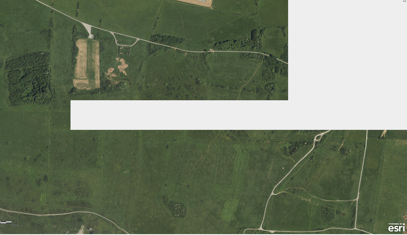
All the tiles display as expected at finer/coarser scale ranges.
I've attempted to rebuild the 1:5000 scale a couple of times with no success.
Any ideas or comments would be greatly appreciated.
Solved! Go to Solution.
Accepted Solutions
- Mark as New
- Bookmark
- Subscribe
- Mute
- Subscribe to RSS Feed
- Permalink
Hi Aled,
What is the maximum number of rasters per mosaic defined in the Mosaic Dataset properties? You can view this in ArcMap by right-clicking on the mosaic dataset > Properties > Defaults > Maximum Number of Rasters per Mosaic.
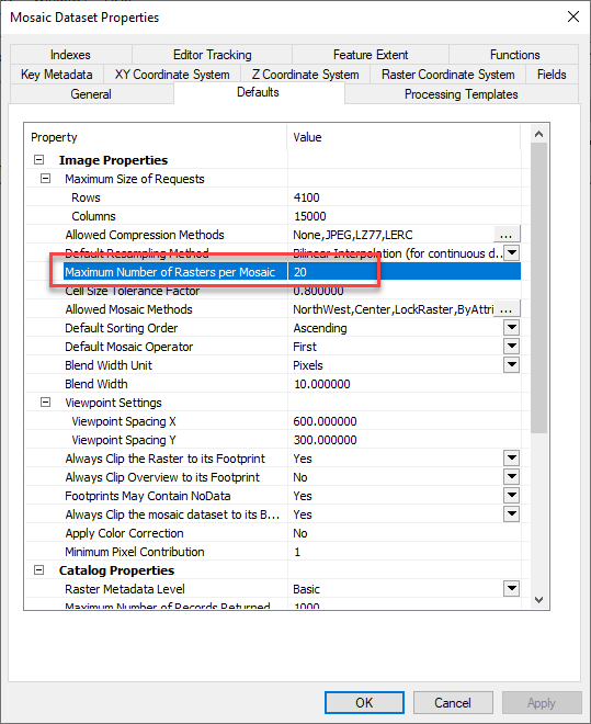
The default value is 20 to prevent the server from mosaicking a very large number of tiles, but as a result this can lead to blank/missing tiles (they are still generated in the cache folder, but if you view the tile images they are white). You can increase this to a higher number, for example, 100 and then generate the cache tiles again.
- Mark as New
- Bookmark
- Subscribe
- Mute
- Subscribe to RSS Feed
- Permalink
If you create a polygon that covers the area for the missing tiles and use it as an area of interest (AOI) when rebuilding the tiles, is there any difference in behavior?
- Mark as New
- Bookmark
- Subscribe
- Mute
- Subscribe to RSS Feed
- Permalink
Many thanks for the suggestion Jill Edstrom Unfortunately, it didn't work.
I've narrowed down the issue to be the tiling scheme i'm attempting to cache this data at.
As I need the data to display in Geocortex in conjunction with an OS basemap, I need to use the standard scales:
http://esriukcontent.maps.arcgis.com/home/item.html?id=75bcde3773e04550ab872109fe61829c
Here are the 'native' tiling scheme values produced by ArcMap for this mosaic dataset.
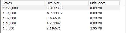
I'm guessing ArcMap calculates these based on the extent of the mosaic dataset?
If I build the cache using these values; the service successfully displays on the javascript viewer (rest endpoint) at all scales.
Using the native tiling scheme in Geocortex results in either the mosaic becoming unusable or the basemap disappearing from the map  .
.
I'm already serving aerial imagery mosaics (built from jpeg tiles, and using the standard scales) on server successfully. The only difference is the size of the mosaic used (this one covers a tiny area of roughly 15km x 15 km).
Things I've tried:
Adding the country border and blanking the symbology (to increase the overall extent) and then caching - still displaying the same issue @ 1:5000 (significantly worse).
Found the cell size range in the mosaic which correlates to the 1:8000 scale, changed this to reflect 1:5000 - no success.
Published the service without a cache - this works, but the sample has been received to test the caching process - it needs to be cached.
I'm starting to think this is either a bug in ArcGIS Server with the way it builds tile caches (no issues with the mosaic at all).
Or, i'm missing an essential part of the mosaic preparation before publishing.
Any ideas to try would be great 
- Mark as New
- Bookmark
- Subscribe
- Mute
- Subscribe to RSS Feed
- Permalink
Considering the details of your workflow, this issue may be environment or data specific. With this in mind, I recommend creating a case with your Esri distributor's technical support. Doing so would allow for an analyst to determine how to best assist you with the behavior you're encountering.
- Mark as New
- Bookmark
- Subscribe
- Mute
- Subscribe to RSS Feed
- Permalink
Hi Aled,
What is the maximum number of rasters per mosaic defined in the Mosaic Dataset properties? You can view this in ArcMap by right-clicking on the mosaic dataset > Properties > Defaults > Maximum Number of Rasters per Mosaic.
The default value is 20 to prevent the server from mosaicking a very large number of tiles, but as a result this can lead to blank/missing tiles (they are still generated in the cache folder, but if you view the tile images they are white). You can increase this to a higher number, for example, 100 and then generate the cache tiles again.
- Mark as New
- Bookmark
- Subscribe
- Mute
- Subscribe to RSS Feed
- Permalink
Hi Rachael,
The maximum number of raster per mosaic was the default at 20. Increasing this number to 50 has resolved my issue .
The current documentation for this parameter is:
Maximum Number Of Rasters Per Mosaic—Prevents the server from mosaicking an unreasonably large number of rasters if, for example, the client zooms in to an overview scale in a nonoptimized image service dataset that has no overview tiles generated. The default is 20.
Mosaic dataset properties—Help | ArcGIS Desktop
To me, the documentation here suggests that the parameter is important for non-cached raster map services (nonoptimized). Additionally, overviews have been produced for the 5000 scale range for my mosaic in question.
Could I suggest adding a line to the tune of "This parameter is considered by ArcGIS Enterprise whilst caching mosaic datasets, a insufficient amount of rasters per mosaic can lead to unexpected behaviour"?
Rachael, thank you very much for this
Best regards,
Aled
- Mark as New
- Bookmark
- Subscribe
- Mute
- Subscribe to RSS Feed
- Permalink
perfect thanks for the fix. Great to see the logic from ArcMap applying in Pro.
What assisted me was running the manage map server cache tiles GP tool at the offending scale to recreate all tile just at the bad scale once I fixed the mosaic properties.