- Home
- :
- All Communities
- :
- Products
- :
- ArcGIS Enterprise
- :
- ArcGIS Enterprise Questions
- :
- Re: Best model for serving raster data
- Subscribe to RSS Feed
- Mark Topic as New
- Mark Topic as Read
- Float this Topic for Current User
- Bookmark
- Subscribe
- Mute
- Printer Friendly Page
- Mark as New
- Bookmark
- Subscribe
- Mute
- Subscribe to RSS Feed
- Permalink
I am wondering what would be the best model for serving our raster image data to our organization. We have web apps and ArcGIS desktop users consuming the data; however, the web apps and the desktop users need to have the data in different projections and on different datums. So, currently we have the image data in a cache on the server's local drive and a map service running off of this for the web apps. For the desktop users the data is in SDE/Oracle and consumed via layer file on a network drive. The image data is used for basemapping only. We have ArcGIS 10.1 server and desktop environments.
The options that I see are:
cached map service - made off a raster data set inside a gdb on the server's local drive
an image service - made off of mosaic data set inside a gdb on the server's local drive (requires ArcGIS Image extension)
a map service - made off a raster data set inside a gdb on the server's local drive
a cached image service - made off of mosaic data set inside a gdb on the server's local drive (requires ArcGIS Image extension)
I do not think that we have any use for the advanced features provided by an image service; Catalog, Download, Edit, etc. However, we do have the ArcGIS Image extension available to us.
ArcGIS: For sharing imagery | ArcGIS Resource Center
So, it looks to me like the best option for speed and simplicity would be a cached map service made off a raster data set inside a gdb on the server's local drive for both the web maps and the ArcGIS desktop users. I think we will still need two services, one for each projection, as we have had bad luck with re-projecting the data on the fly in the past. Then we can do away with loading the image data into SDE/Oracle. Does this sound right?
Solved! Go to Solution.
Accepted Solutions
- Mark as New
- Bookmark
- Subscribe
- Mute
- Subscribe to RSS Feed
- Permalink
I would look into What is a mosaic dataset?—Help | ArcGIS for Desktop for managing and use the What are the functions used by a raster or mosaic dataset?—Help | ArcGIS for Desktop for users within your office using the desktop software. But for services, you are correct you would need the image server extension. I'm about to do the same at my office (in a couple weeks probably) and have only been tinkering so far. What I've played with so far has been very promising, and for us, the increased speed of caching the imagery (8 weeks, to about 7 days...with added scale levels) will make it pay for itself, long term (in my opinion).
edit...btw, I'm not storing imagery in SDE anymore either. Mosaic datasets and fgdb are much nicer for imagery IMO.
- Mark as New
- Bookmark
- Subscribe
- Mute
- Subscribe to RSS Feed
- Permalink
Thanks for the feedback Rebecca.
Wow, 8 weeks to 7 days is huge.
So, for people in your office are you just planing on having a the mosaic dataset in a fgdb on a network drive That they will hit with a layer file?
- Mark as New
- Bookmark
- Subscribe
- Mute
- Subscribe to RSS Feed
- Permalink
Forest, that us what I'm hoping. We have a lot of server/network upgrades going on, but in my research so far, I think all that will work. I'll probably be duplicating/distributing the mosaic/fgdb to multiple locations (Large state...not great network connectivity ) but it is all theory for me right now ( and still waiting for delivery of some new data).
The caching test was done with imagery of about 45% of the state, but where our largest scale was 1:24k, I add 12.5, 5k, and another scale ( can't remember offhand), so I was pretty excited about that.
If ALL you want the image extension for is caching, you may want to look into Esri Developer Network (EDN) which gives some options for this (although I would check the details of licensing with your customer service rep and not go on my word). I went for the extension, but tested with EDN first.
- Mark as New
- Bookmark
- Subscribe
- Mute
- Subscribe to RSS Feed
- Permalink
Rebecca Strauch, GISP:
Forest, that [is] what I'm hoping. We have a lot of server/network upgrades going on, but in my research so far, I think all that will work. I'll probably be duplicating/distributing the mosaic/fgdb to multiple locations (Large state...not great network connectivity ) but it is all theory for me right now ( and still waiting for delivery of some new data).
Great, that is what we are thinking as well. One fgdb at the main office and one more for the remote part of the state. I am going to give this part a go once we get this summers orthos in. Thanks for the input.
Thanks for the EDN link. At first look our agreement with esri does most likely include the image extension, but I will have to follow up a little to know for sure...
- Mark as New
- Bookmark
- Subscribe
- Mute
- Subscribe to RSS Feed
- Permalink
Hi Forest,
I recommend mosaic datasets over raster datasets. It saves time in creating, saves storage space, and they perform faster. When dealing with services, whether you are dealing with a cached map service or image service, the speed should be the same. However, a cached image service will be much faster than a non-cached image service.
Using the PerQAnalyzer, I compared the speeds of a cached image service:
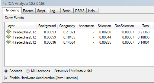
vs a non-cached image service:
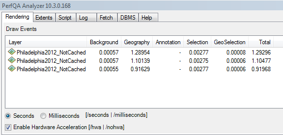
You can see the rendering speed (Total column) is much faster. It may take sometime to build the cache, but the performance will be worth it.
- Mark as New
- Bookmark
- Subscribe
- Mute
- Subscribe to RSS Feed
- Permalink
Thank you for the feedback Jake. Am I right in thinking that the speed of the cached map service should be the same regardless of the underlying data it was made from, raster dataset vs. mosaic dataset? The main reason to use the mosaic dataset would be the faster creation time of the dataset and the faster caching time of said data set.
- Mark as New
- Bookmark
- Subscribe
- Mute
- Subscribe to RSS Feed
- Permalink
Hi Forest,
Yes, this is correct, though I haven't tested the speed of creating the cache of a mosaic dataset vs a raster dataset.