- Home
- :
- All Communities
- :
- Products
- :
- ArcGIS Enterprise
- :
- ArcGIS Enterprise Questions
- :
- Re: Are there any dynamic map applications that co...
- Subscribe to RSS Feed
- Mark Topic as New
- Mark Topic as Read
- Float this Topic for Current User
- Bookmark
- Subscribe
- Mute
- Printer Friendly Page
Are there any dynamic map applications that cost less than $500 per year?
- Mark as New
- Bookmark
- Subscribe
- Mute
- Subscribe to RSS Feed
- Permalink
Many inexpensive mobile map applications, like Avenza, are great, aside from the non-dynamic aspect - you can't click on elements to see attached documents, photos or more details (unless you have added the pin yourself, and even then it is very limited) and when you zoom in /out the static nature of the map leaves much to be desired on the interactive-front.
Interactive mobile map applications such as Collector or Carry Maps all ask for $500 per device/user per year. This can be costly if you only wish to reference data and not input data, but the dynamic nature and scalability of the applications is what field techs prefer and what makes field work easier overall.
Does anyone know of any map applications like Collector or Carry Maps that is less expensive than $500 per user per year that will integrate with shapefiles from ArcGIS Desktop?
- Mark as New
- Bookmark
- Subscribe
- Mute
- Subscribe to RSS Feed
- Permalink
Explorer for ArcGIS may be an app that will work for you? Explorer for ArcGIS | ArcGIS
Could you explain more about your desire and workflow in regards to "integrate with shapefiles" ?
Thanks,
mark
- Mark as New
- Bookmark
- Subscribe
- Mute
- Subscribe to RSS Feed
- Permalink
Thank you for your response! I have heard from a few people that Explorer for ArcGIS might be a potential, it's in Beta testing for Android right now so I have an ESRI rep testing out our layers with it to see whether or not it would work for what I need.
What I meant by integrate with shapefiles is that I could have individual layers with vector objects that can be selected for additional details, like polygons, and not just a tiled image package or georeferenced pdf as a base map (such as what Avenza would offer).
Have you heard of CartoMaps or Fulcrum? Those are others that were offered as possible solutions.
- Mark as New
- Bookmark
- Subscribe
- Mute
- Subscribe to RSS Feed
- Permalink
You can create maps with feature data in them for use in Explorer. Explorer users can tap on features to see attributes and search for features by attribute. You can author the map with the specific feature capabilities that you want to provide. Explorer can make use of a webmap (created with ArcGIS online) or and offline map (Mobile Map Package (.mmpk)) created with ArcGIS Pro.
- Mark as New
- Bookmark
- Subscribe
- Mute
- Subscribe to RSS Feed
- Permalink
Awesome! We have very large data sets because of image and document attachments - do you know if that is an issue with Explorer? Also, do the offline basemaps work the same in Explorer as they did for collector with side loading, etc?
- Mark as New
- Bookmark
- Subscribe
- Mute
- Subscribe to RSS Feed
- Permalink
Kara,
there are some issues with lots of attachments and big attachments that we are working on. In regards to basemaps, Mobile Map Package contain Operational layers and basemap in the same mobile map. The Mobile Map package can be side loaded.
Mark
- Mark as New
- Bookmark
- Subscribe
- Mute
- Subscribe to RSS Feed
- Permalink
Mark,
I heard the following from an ESRI customer service rep today, is this correct? Because it seems to be a little different than what we have discussed in this string:
- Explorer for offline use only works with MMPK's - whether directly side-loaded or published through ArcGIS Online
- ArcGIS Pro will support exporting MMPK's with basemap imagery in 2-3 months
- I would need a Publisher extension with ArcGIS Pro to export an MMPK with any base map imagery (2500 +500 maint fee per year)
- Mark as New
- Bookmark
- Subscribe
- Mute
- Subscribe to RSS Feed
- Permalink
Kara,
~Explorer for offline use only works with MMPK's - whether directly side-loaded or published through ArcGIS Online
Mobile map packages can be shared on a portal as well.
~ArcGIS Pro will support exporting MMPK's with basemap imagery in 2-3 months
There will be opportunities to use "Current Esri online basemaps" offline in the future.
~I would need a Publisher extension with ArcGIS Pro to export an MMPK with any base map imagery (2500 +500 maint fee per year)
If you want to share Mobile Map Packages with anonymous users / the public (un-named users), you will need to create the Mobile Map package for anonymous use, using the Publisher Extension.
The Publisher Extension is not needed if you are sharing maps with named users.
Mark
- Mark as New
- Bookmark
- Subscribe
- Mute
- Subscribe to RSS Feed
- Permalink
Thanks, Mark, let me see if I understand what you are saying by describing what I want to do with Explorer for ArcGIS:
- I can pull in multiple vector layers into ArcGIS Pro and one of those vector layers is a parcel layer with thousands of image attachments.
- I will eventually be able to add an aerial imagery basemap to this ArcGIS Pro map and then export the entire thing as a Mobile Map Package
- Because I will have 3 named users with VIEWER license ($100 each), I will be able to do all of this without the need for the Publisher Extension or any other additional feature that costs extra money beyond our Workgroup License
- I will be able to download this map for offline use on an Android Tablet and side load different basemaps from a micro-sd card depending on where the user goes in the field
- The data size available for offline basemap use will be limited to my micro-sd card only
- What is the data size limit for vector layers in Explorer for ArcGIS?
- Mark as New
- Bookmark
- Subscribe
- Mute
- Subscribe to RSS Feed
- Permalink
Kara,
Sure I will respond to each:
~I can pull in multiple vector layers into ArcGIS Pro and one of those vector layers is a parcel layer with thousands of image attachments.
Yes you can. How many image attachments do you typically have for each parcel and what format and size?
~Because I will have 3 named users with VIEWER license ($100 each), I will be able to do all of this without the need for the Publisher Extension or any other additional feature that costs extra money beyond our Workgroup License
Signed in users can use offline maps (mobile map packages .mmpk) created with ArcGIS Pro. The Publisher extension is not needed to create Mobile Map Packages. Publisher extension is only needed if you want to share maps with anonymous users. In your case, Publisher extension is not needed.
~I will be able to download this map for offline use on an Android Tablet and side load different basemaps from a micro-sd card depending on where the user goes in the field
This wording is a little off. At this time you can use Mobile Map packages. The maps contain operational layers and a basemap. You cannot switch basemaps. This is how ti works today for offline maps. In the future, perhaps later this year, you will be able to switch basemaps in offline maps, exact permutations for how that works, in regards to micro-sd cards etc... still needs to be worked out.
~The data size available for offline basemap use will be limited to my micro-sd card only
Yes, limited by the space available on your device.
~What is the data size limit for vector layers in Explorer for ArcGIS?
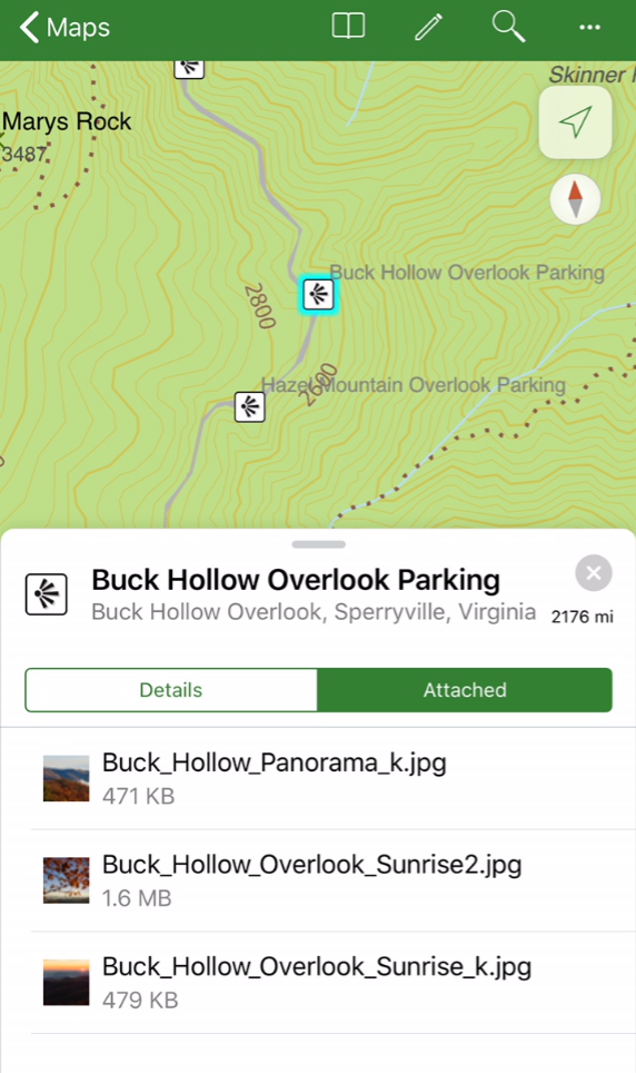
Primarily the amount of space on your device is the limiting factor. I have used datasets in excess of 3 Gigabytes. You will still want to author your maps with scale visibility settings that display a reasonable number of features at any one time. You can check out this example. http://www.arcgis.com/home/item.html?id=6ca5f9cfea0c47b2969ee9750693301f
In Explorer search for ' Shenandoah National Park ' the contour lines in this map will give you a pretty good idea for what is possible. In the map, if you search for 'Buck Hollow Overlook Parking' you will see a feature with attachments.