- Home
- :
- All Communities
- :
- Products
- :
- ArcGIS Enterprise
- :
- ArcGIS Enterprise Portal Questions
- :
- Portal 10.6.1: Identified Symbol Selection Incorre...
- Subscribe to RSS Feed
- Mark Topic as New
- Mark Topic as Read
- Float this Topic for Current User
- Bookmark
- Subscribe
- Mute
- Printer Friendly Page
Portal 10.6.1: Identified Symbol Selection Incorrect
- Mark as New
- Bookmark
- Subscribe
- Mute
- Subscribe to RSS Feed
- Permalink
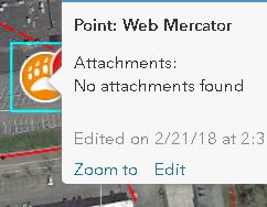
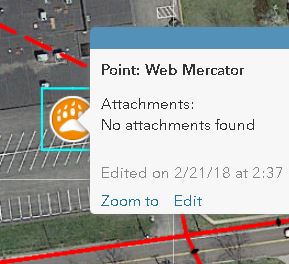
I've upgraded two development environments from ArcGIS Enterprise 10.5.1 to 10.6.1. While regression testing some of our applications I noticed some odd behavior. When identifying features from a map service with a web map or web application the selected geometry/symbol when identifying returns incorrectly when zoomed into a large scale.
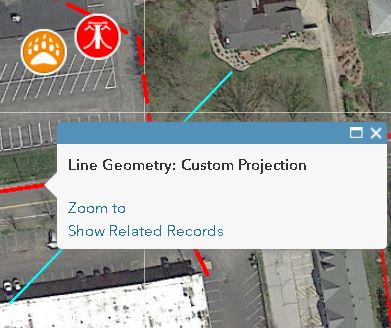
When identifying features at 1:2,257 the proper geometry/symbol is highlighted, however when zooming in to the next scale the highlighted feature is incorrect. I've attached some example pictures to portray the issue. Our services are using custom projection. It seems as though there is not an issue with portal feature layers projected in Web Mercator. It doesn't matter if I use an ESRI basemap in Web Mercator or a basemap with our custom projection, the highlighted area is still portrayed incorrectly. I've even uploaded some data projected in a different WKID and the same issue occurs.
Has anyone observed this issue? Having the feature highlighted when identifying is very beneficial for our users.
Solved! Go to Solution.
Accepted Solutions
- Mark as New
- Bookmark
- Subscribe
- Mute
- Subscribe to RSS Feed
- Permalink
ESRI has put out a patch to resolve this issue:
- Mark as New
- Bookmark
- Subscribe
- Mute
- Subscribe to RSS Feed
- Permalink
Looks like this has been labeled as a bug, BUG-000115859, and there is a forum post with the exact same issue. Our server is running Windows 2016 and the issue still applies.
- Mark as New
- Bookmark
- Subscribe
- Mute
- Subscribe to RSS Feed
- Permalink
ESRI has put out a patch to resolve this issue: