Turn on suggestions
Auto-suggest helps you quickly narrow down your search results by suggesting possible matches as you type.
Cancel
- Home
- :
- All Communities
- :
- Products
- :
- ArcGIS Enterprise
- :
- ArcGIS Enterprise Portal Questions
- :
- Re: How to get the data together?
Options
- Subscribe to RSS Feed
- Mark Topic as New
- Mark Topic as Read
- Float this Topic for Current User
- Bookmark
- Subscribe
- Mute
- Printer Friendly Page
09-22-2012
04:32 AM
- Mark as New
- Bookmark
- Subscribe
- Mute
- Subscribe to RSS Feed
- Permalink
Dear all,
sorry for the question but I really don't know where to start with this...
I have a GeoTiff, created by the program sir_util2 ( ftp://ftp.scp.byu.edu/software/windows_utils/sir_util2.exe ) and I have some points I would like to overlay. The points are coming as lat/long (WGS84). I was loading first the raster file and then the vector file into ArcMAP and they don't line up. If you are interested in the files please find them here: https://dl.dropbox.com/u/38524090/QuikSCAT.zip.
First I thought the vector file was the problem but when I was loading the polygon layer for the continents, provided by ESRI, then the points are at the expected location and the raster file is way off.
Does somebody have an idea how to get the data together? The projection needed is Stereographic_North_Pole and in theory the raster dataset should have the correct projection but somehow it doesn't work.
Thanks in advance,
Thomas
- We are living in the 21st century.
GIS moved on and nobody needs a format consisting out of at least three files! No, nobody needs shapefiles, not even for the sake of an exchange format. Folks, use GeoPackage to exchange data with other GIS!
GIS moved on and nobody needs a format consisting out of at least three files! No, nobody needs shapefiles, not even for the sake of an exchange format. Folks, use GeoPackage to exchange data with other GIS!
Solved! Go to Solution.
1 Solution
Accepted Solutions
09-24-2012
08:52 AM
- Mark as New
- Bookmark
- Subscribe
- Mute
- Subscribe to RSS Feed
- Permalink
(some clipped...)
Here is what I know about the raster file:
gdalinfo:
PROJCS["unnamed",
[INDENT]GEOGCS["WGS 84",
[INDENT]DATUM["WGS_1984",
[INDENT]SPHEROID["WGS 84",6378137,298.2572235630016,
[INDENT]AUTHORITY["EPSG","7030"]],[/INDENT]
AUTHORITY["EPSG","6326"]],[/INDENT]
PRIMEM["Greenwich",0],
UNIT["degree",0.0174532925199433],
AUTHORITY["EPSG","4326"]],[/INDENT]
PROJECTION["Polar_Stereographic"],
PARAMETER["latitude_of_origin",70],
PARAMETER["central_meridian",-45], PARAMETER["scale_factor",1],
PARAMETER["false_easting",0],
PARAMETER["false_northing",0],
UNIT["metre",1,
Polar sterographic projection:
Image size: (3060 X 3060)
Elliptical Earth radius=6378.273000 (km) e2=0.006693883 Reference point: lon=-45.000000 , lat=70.000000 (deg)
X,Y scales: lon=2.225000 , lat=2.225000 (km/pix)
Lower-Left Corner: x=-3400.000000 , y=-3400.000000 (km/pix)
I believe there are two issues with the definition. It's either being converted by ArcGIS to Stereographic_North_Pole or Stereographic, or nothing. What does ArcGIS say the coordinate system is? Anyway, I think it's being read as Stereographic, because the raster is centered at 45W, 70N. I think it should be centered at 45W, 90N, with a standard parallel at 70N.
The other issue is the discrepancy in the ellipsoid/spheroid being used. These values:
Elliptical Earth radius=6378.273000 (km) e2=0.006693883
are Hughes 1980. While we have a GCS for Hughes 1980, it's not a true geodetic datum/geographic coordinate system, so there are no transformations between it and WGS84. Anyway, we have this definition already, it's "NSIDC Sea Ice Polar Stereographic North" and can be found in the projected coordinate systems, polar folder. Try redefining the data to this.
If you still see a north-south offset that gets worse the farther from the pole, try setting a custom geographic (datum) transformation between Hughes 1980 and WGS 1984. Use the geocentric translation method, and leave the parameter values set to zeroes. Perhaps try it in ArcMap first (access it from data frame properties, coordinate system tab, transformation button.
EDIT: The coordinate system is not 100% NSIDC Sea Ice Polar Stereographic North. There's a false northing in the coordinate system of -6800000 meters. I'm attaching the coordinate system prj file that appears to work reasonably well. I have to rename it to a .txt file to upload it. Or when you redefine the coordinate system for the raster, choose the NSIDC one, then modify it to have a false northing = -6800000.0.
Melita
4 Replies
09-23-2012
02:31 PM
- Mark as New
- Bookmark
- Subscribe
- Mute
- Subscribe to RSS Feed
- Permalink
Hi Thomas,
If everything you have all lines up but not to the Image then your Image is out, the program you are using to create the Geotiff is probably not creating the projection properly. Have you tried outputting the image in WGS84 or possibly even web mercator ? The image to me is dropping in the ocean between America and Africa. I can't quite tell what that Image is supposed to be, is that looking at the Earth from top down ? If you know where it is supposed to be and have sufficient data you can always try re georeference it in Arcmap.
Hope this helps.
Shaun.
09-24-2012
05:48 AM
- Mark as New
- Bookmark
- Subscribe
- Mute
- Subscribe to RSS Feed
- Permalink
Hi Shaun,
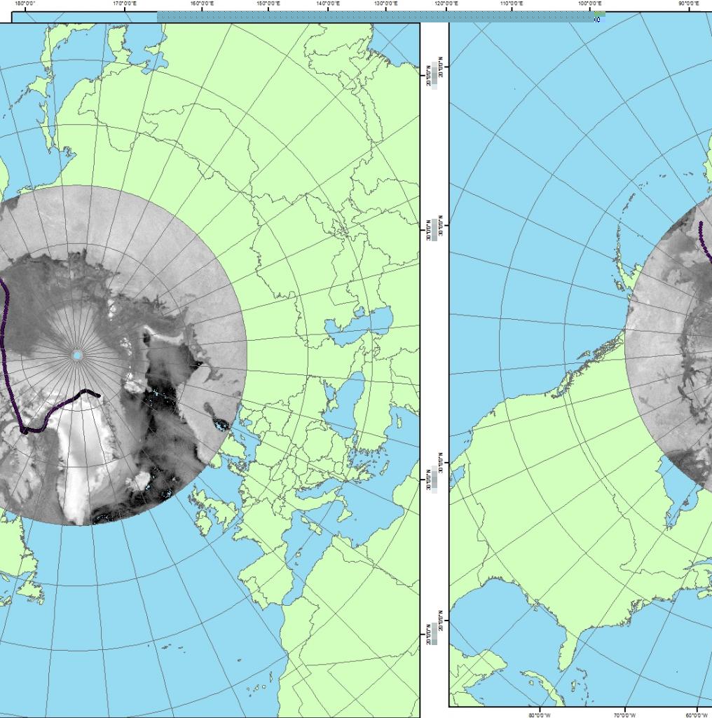
you are absolutely right and it's the same here... The whole thing goes to swim between Africa and America.
[ATTACH=CONFIG]17915[/ATTACH]
Greenland is actually good to recognize. The white spot in the middle of the raster file is where the north pole should be.
I also tried to warp the image using GDAL and acquired some information from gdalinfo and output from the original sir_util2.exe where a possibility is given to retrieve the corner points. I cant really make heads and tails out of it but some of the cartographers might... 😉
Bests Thomas
Here is what I know about the raster file:
gdalinfo:
PROJCS["unnamed",
[INDENT]GEOGCS["WGS 84",
[INDENT]DATUM["WGS_1984",
[INDENT]SPHEROID["WGS 84",6378137,298.2572235630016,
[INDENT]AUTHORITY["EPSG","7030"]],[/INDENT]
AUTHORITY["EPSG","6326"]],[/INDENT]
PRIMEM["Greenwich",0],
UNIT["degree",0.0174532925199433],
AUTHORITY["EPSG","4326"]],[/INDENT]
PROJECTION["Polar_Stereographic"],
PARAMETER["latitude_of_origin",70],
PARAMETER["central_meridian",-45],
PARAMETER["scale_factor",1],
PARAMETER["false_easting",0],
PARAMETER["false_northing",0],
UNIT["metre",1,
[INDENT]AUTHORITY["EPSG","9001"]]][/INDENT][/INDENT]
Origin = (-3400000.000000000000000,-3400000.000000000000000)
Pixel Size = (2225.000000000000000,-2225.000000000000000)
Metadata:
[INDENT]AREA_OR_POINT=Area
TIFFTAG_XRESOLUTION=96
TIFFTAG_YRESOLUTION=96
TIFFTAG_RESOLUTIONUNIT=2 (pixels/inch)[/INDENT]
Image Structure Metadata:
[INDENT]INTERLEAVE=BAND[/INDENT]
Corner Coordinates:
Upper Left (-3400000.000,-3400000.000) ( 90d 0'0.00"W, 47d35'3.32"N)
Lower Left (-3400000.000,-10208500.000) ( 63d25'14.29"W, 7d50'3.33"N)
Upper Right ( 3408500.000,-3400000.000) ( 0d 4'17.51"E, 47d32'8.80"N)
Lower Right ( 3408500.000,-10208500.000) ( 26d32'11.15"W, 7d49'11.94"N)
Center ( 4250.000,-6804250.000) ( 44d57'51.17"W, 32d23'29.45"N)
Band 1 Block=3060x1 Type=Byte, ColorInterp=Gray
and the output of the corner points option:
Polar sterographic projection:
Image size: (3060 X 3060)
Elliptical Earth radius=6378.273000 (km) e2=0.006693883
Reference point: lon=-45.000000 , lat=70.000000 (deg)
X,Y scales: lon=2.225000 , lat=2.225000 (km/pix)
Lower-Left Corner: x=-3400.000000 , y=-3400.000000 (km/pix)
Image corner locations (location at lower-left of pixel)
LL: (x=1, y=1) lon=-90.000000 lat=47.585083
UL: (x=1, y=3060) lon=179.947174 lat=47.549301
UR: (x=3060, y=3060) lon=90.000000 lat=47.513561
LR: (x=3060, y=1) lon=0.052820 lat=47.549301
Image corner locations (location at center of pixel)
LL: (x=1, y=1) lon=-90.000000 lat=47.597767
UL: (x=1, y=3060) lon=179.928452 lat=47.549286
UR: (x=3060, y=3060) lon=90.000000 lat=47.500881
LR: (x=3060, y=1) lon=0.071551 lat=47.549286
- We are living in the 21st century.
GIS moved on and nobody needs a format consisting out of at least three files! No, nobody needs shapefiles, not even for the sake of an exchange format. Folks, use GeoPackage to exchange data with other GIS!
GIS moved on and nobody needs a format consisting out of at least three files! No, nobody needs shapefiles, not even for the sake of an exchange format. Folks, use GeoPackage to exchange data with other GIS!
09-24-2012
08:52 AM
- Mark as New
- Bookmark
- Subscribe
- Mute
- Subscribe to RSS Feed
- Permalink
(some clipped...)
Here is what I know about the raster file:
gdalinfo:
PROJCS["unnamed",
[INDENT]GEOGCS["WGS 84",
[INDENT]DATUM["WGS_1984",
[INDENT]SPHEROID["WGS 84",6378137,298.2572235630016,
[INDENT]AUTHORITY["EPSG","7030"]],[/INDENT]
AUTHORITY["EPSG","6326"]],[/INDENT]
PRIMEM["Greenwich",0],
UNIT["degree",0.0174532925199433],
AUTHORITY["EPSG","4326"]],[/INDENT]
PROJECTION["Polar_Stereographic"],
PARAMETER["latitude_of_origin",70],
PARAMETER["central_meridian",-45], PARAMETER["scale_factor",1],
PARAMETER["false_easting",0],
PARAMETER["false_northing",0],
UNIT["metre",1,
Polar sterographic projection:
Image size: (3060 X 3060)
Elliptical Earth radius=6378.273000 (km) e2=0.006693883 Reference point: lon=-45.000000 , lat=70.000000 (deg)
X,Y scales: lon=2.225000 , lat=2.225000 (km/pix)
Lower-Left Corner: x=-3400.000000 , y=-3400.000000 (km/pix)
I believe there are two issues with the definition. It's either being converted by ArcGIS to Stereographic_North_Pole or Stereographic, or nothing. What does ArcGIS say the coordinate system is? Anyway, I think it's being read as Stereographic, because the raster is centered at 45W, 70N. I think it should be centered at 45W, 90N, with a standard parallel at 70N.
The other issue is the discrepancy in the ellipsoid/spheroid being used. These values:
Elliptical Earth radius=6378.273000 (km) e2=0.006693883
are Hughes 1980. While we have a GCS for Hughes 1980, it's not a true geodetic datum/geographic coordinate system, so there are no transformations between it and WGS84. Anyway, we have this definition already, it's "NSIDC Sea Ice Polar Stereographic North" and can be found in the projected coordinate systems, polar folder. Try redefining the data to this.
If you still see a north-south offset that gets worse the farther from the pole, try setting a custom geographic (datum) transformation between Hughes 1980 and WGS 1984. Use the geocentric translation method, and leave the parameter values set to zeroes. Perhaps try it in ArcMap first (access it from data frame properties, coordinate system tab, transformation button.
EDIT: The coordinate system is not 100% NSIDC Sea Ice Polar Stereographic North. There's a false northing in the coordinate system of -6800000 meters. I'm attaching the coordinate system prj file that appears to work reasonably well. I have to rename it to a .txt file to upload it. Or when you redefine the coordinate system for the raster, choose the NSIDC one, then modify it to have a false northing = -6800000.0.
Melita