- Home
- :
- All Communities
- :
- Products
- :
- ArcGIS Enterprise
- :
- ArcGIS Enterprise Portal Questions
- :
- Re: How can I convert aritmetic degree to geograph...
- Subscribe to RSS Feed
- Mark Topic as New
- Mark Topic as Read
- Float this Topic for Current User
- Bookmark
- Subscribe
- Mute
- Printer Friendly Page
How can I convert aritmetic degree to geographic?
- Mark as New
- Bookmark
- Subscribe
- Mute
- Subscribe to RSS Feed
- Permalink
The difference of the two has been explained in another post:
"A note for those not familiar with rotation options. Geographic rotation establishes due north as angle 0 and degrees above 0 cause a clockwise rotation so that due east is 90, due south is 180 and due west is 270. It's rules are designed to operate like a clock. An Arithmetic rotation follows Cartesian graphing rules and is what mathematicians use. It establishes the X axis in the positive direction (X = +, Y = 0) or due east in compass directions as 0 and degrees above 0 cause a counterclockwise rotation. In an arithmetic system due north is 90 degrees (X = 0, Y = +), due west is 180 degrees (X = -, Y = 0), and due south is 270 degrees (X = 0, Y = -)."
The concept is clear to me... but how can I caculate one from the other? As I have aritmetic direction in my data, but I need them in geographic degree.
Thank you! Frauke
- Mark as New
- Bookmark
- Subscribe
- Mute
- Subscribe to RSS Feed
- Permalink
Have a look here, quite old:
- Mark as New
- Bookmark
- Subscribe
- Mute
- Subscribe to RSS Feed
- Permalink
Dear Johannes,
I found the old post too, but the script logically does not work for me. Maybe I have some missunderstanding.
But if I try to apply this script to my arithmetic value of f.e. 270°, which is pointing to the west:
270 + 270 = 540
this is > 360: 540 - 360 = 180°
... and it should be 90° in geometric direction?!? This script is just 'shifting' the values, but not taking into account the 'counter clock rotation' of the arimetic direction. As I am not that much into VBA I might miss something here.
I would be happy about advice!
Thank you!
- Mark as New
- Bookmark
- Subscribe
- Mute
- Subscribe to RSS Feed
- Permalink
Fire up python and go all command line
>>> import math
>>> pnt_1 = [1.0,-1.0]
>>> pnt_0 = [0.0,0.0]
>>> radian = math.atan((pnt_1[0] - pnt_0[0])/(pnt_1[1] - pnt_0[1]))
>>> radian
-0.7853981633974483
>>> degrees = math.degrees(radian)
>>> if degrees < 0.0:
... degrees += 360
...
>>> degrees
315.0
>>>
If you want to determine the azimuth of a polyline, then you can use this field calculator function
''' input shape field: returns angle between 0 and <360 based upon the first and last point
polyline_azimuth(!Shape!)    #enter into the expression box'''
import math
def polyline_azimuth(shape):
  radian = math.atan((shape.lastPoint.X - shape.firstPoint.X)/(shape.lastPoint.Y - shape.firstPoint.Y))
  degrees = math.degrees(radian)
  if degrees <0:
    return degrees + 360
  else:
    return degrees
- Mark as New
- Bookmark
- Subscribe
- Mute
- Subscribe to RSS Feed
- Permalink
Well, it seems to be that this post is almost 2 years old. Nevertheless there is an easier way to calculate from arithmetic into geographic degrees.
This is what I got:
(Calculation in ArcMap - Phyton)
def CalcGeograpicAngle(arith):
if (arith >90 and arith <360):
return (360-arith+90)
elif (arith>=0 and arith <= 90):
return (arith*(-1)+90)
It worked for me and the vice versa should be also easy like that.
- Mark as New
- Bookmark
- Subscribe
- Mute
- Subscribe to RSS Feed
- Permalink
I think a cleaner solution would be a single expression.
def CalcGeographicAngle(arith):
return (360 - arith + 90) % 360
- Mark as New
- Bookmark
- Subscribe
- Mute
- Subscribe to RSS Feed
- Permalink
or... (450-arith) % 360
- Mark as New
- Bookmark
- Subscribe
- Mute
- Subscribe to RSS Feed
- Permalink
Yeah, this modulo operation (%) is cool! See: https://en.wikipedia.org/wiki/Modulo_operation
And, by the way, the formula works both ways, so both from Arithmetic to Geographic and from Geographic to Arithmetic, just like a switch:
# e.g. Geographic North (12 o'clock) = 0
(450 - 0) % 360 # returns 90 (Arithmetic)
# e.g. Arithmetic South (6 o'clock) = 270
(450 - 270) % 360 # returns 180 (Geographic)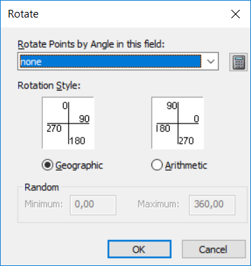
- Mark as New
- Bookmark
- Subscribe
- Mute
- Subscribe to RSS Feed
- Permalink
Derek Nalder's way:
def CalcGeographicAngle(arith):
return (360 - arith + 90) % 360is actually the more "pythonic" way of doing this. It is better to be explicit then implicit, and I think it is much easier to understand what is happening with his version.
- Mark as New
- Bookmark
- Subscribe
- Mute
- Subscribe to RSS Feed
- Permalink
I suppose... but if you rotate a circle by 90 degrees, the origin vector has moved through 450 degrees. Think of the arm of a clock, it travels 450 degrees in an hour and 15 minutes