- Home
- :
- All Communities
- :
- Products
- :
- ArcGIS Reality
- :
- ArcGIS Drone2Map
- :
- ArcGIS Drone2Map Questions
- :
- Re: Dynamic Mosaic Creation Failed
- Subscribe to RSS Feed
- Mark Topic as New
- Mark Topic as Read
- Float this Topic for Current User
- Bookmark
- Subscribe
- Mute
- Printer Friendly Page
Dynamic Mosaic Creation Failed
- Mark as New
- Bookmark
- Subscribe
- Mute
- Subscribe to RSS Feed
- Permalink
- Report Inappropriate Content
I just began using the latest Drone2Map and I am receiving an error at the end of initial processing in regards failing to create the mosaic dataset. Since the mosaic dataset is not created the Estimate Links is not enabled in the Image Links Editor. I am just running the initial step so I can use the Assisted Link feature using my imported GPS collected control points.
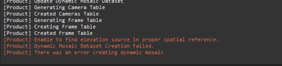
From the D2M log:

My GPS data is in WGS84 with vertical reference GEOID12. In previous Drone2Map releases, I just left everything default and things worked smoothly. Do I need to adjust anything now when importing control points from a feature class? Please let me know what additional information would help.
Thank you
- Mark as New
- Bookmark
- Subscribe
- Mute
- Subscribe to RSS Feed
- Permalink
- Report Inappropriate Content
Hi Trent,
We've identified an issue with creating the dynamic mosaic when control is in WGS84. We are actively working on a fix. In the meantime the workaround for using estimated images links, is to use control in a projected coord system.
Best,
Tony Mason
- Mark as New
- Bookmark
- Subscribe
- Mute
- Subscribe to RSS Feed
- Permalink
- Report Inappropriate Content
Thank you, Anthony. That's what I needed to know!
- Mark as New
- Bookmark
- Subscribe
- Mute
- Subscribe to RSS Feed
- Permalink
- Report Inappropriate Content
Is there still an issue with Estimate Links not working in WGS84? I'm working on an assignment and cannot get the Estimates Links to line up with the image links I manually place. They almost seem randomly placed. I have been following these directions:
https://doc.arcgis.com/en/drone2map/latest/help/control.htm
I'm afraid if I use a projected coord system it will cause errors. Any updated info would be greatly appreciated!