- Home
- :
- All Communities
- :
- Products
- :
- ArcGIS Dashboards
- :
- ArcGIS Dashboards Questions
- :
- Re: operation dashboard: sum area error
- Subscribe to RSS Feed
- Mark Topic as New
- Mark Topic as Read
- Float this Topic for Current User
- Bookmark
- Subscribe
- Mute
- Printer Friendly Page
operation dashboard: sum area error
- Mark as New
- Bookmark
- Subscribe
- Mute
- Subscribe to RSS Feed
- Permalink
In Operation Dahboard I'm trying to use a simple Indicator widget to summarize area from a polygon layer in my webmap (using SHAPE AREA FIELD)
The SHAPE AREA FIELD is visible either in the mxd either in the map service and AGOL webmap: I can also see it in Operations Dashboard widget properties panel but when i use the SUM option with tthe SHAPE-AREA field nothing appears but a message error (yellow triangle in preview): impossible to access the data.
Same thin if i chose minimum, maximum o r standar deviation options
If I make the same thingswith other numeric fields the widget works properly.
Any Suggestion???
- Mark as New
- Bookmark
- Subscribe
- Mute
- Subscribe to RSS Feed
- Permalink
Is you data hosted on AGOL or via your own server?
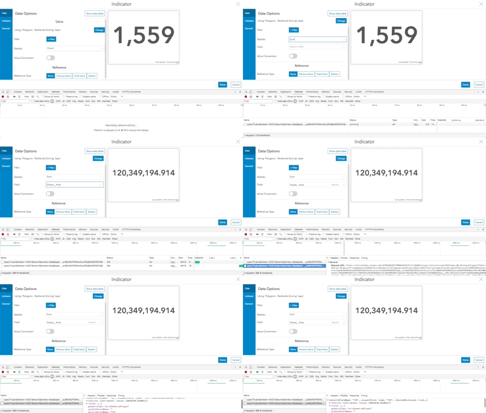
Can you open developer tools (in Chrome) and navigate to the network tab. Then if you change the statistic to be the "SUM" of the Shape_Area field, you should see that network request being sent to the server.
If you click on the request, and open the "Preview" tab, you should see what the response from the server is.
What do you see?

- Mark as New
- Bookmark
- Subscribe
- Mute
- Subscribe to RSS Feed
- Permalink
Thank you for the help.
Unfortunately in the preview I see am error:
- {error: {code: 400, message: "Unable to complete operation.", details: []}}
- error:{code: 400, message: "Unable to complete operation.", details: []}
- code:400
- details:[]
- message:"Unable to complete operation."
- error:{code: 400, message: "Unable to complete operation.", details: []}
I f i use the same layer with another numeric field the resoponse ios correct: for example
- {displayFieldName: "", fieldAliases: {VALUE: "VALUE"},…}
- displayFieldName:""
- features:[{attributes: {VALUE: null}}]
- fieldAliases:{VALUE: "VALUE"}
- fields:[{name: "VALUE", type: "esriFieldTypeDouble", alias: "VALUE"}]
I tried to restart or roverwrite teh service but nothing happens.
- Mark as New
- Bookmark
- Subscribe
- Mute
- Subscribe to RSS Feed
- Permalink
It seems that your service was running into some problem when it tries to process this "get statistic" query. Is it possible for you to check the ArcGIS Server log (please turn on the Verbose log level) when you make this query, to see if you can get more detail out of why the server complains about the request?
Thanks
Tif
- Mark as New
- Bookmark
- Subscribe
- Mute
- Subscribe to RSS Feed
- Permalink
Thank you Tif,
when query is made from Operation Dashboard the ArcFGIS Server manager log is always:
SEVERE Geodatabase error: Attribute column not found[ORA-00904: "SHAPE"."AREA": identificativo non valido].
(translation for identificativo non valido] non valid identifier)
Searching the net it seems and Oralce error message due to characters field name
ORA-00904 invalid identifier tips
So I tryed to change the ALIAS for the SHAPE.AREA field in SDE ("AREA") and also in ArcMAP
I tried to serve also a new MXD and service
but nothiong change and the error is always the same.
Everty other SUM operation in Op. Dash using other numeric fields works correctly.
hera one of the maps ervice used for test:
sviluppo/test_area (MapServer)
Thank you for your help
Enrico
- Mark as New
- Bookmark
- Subscribe
- Mute
- Subscribe to RSS Feed
- Permalink
Were you able to get this fixed? I'm having the same issue as well.
Thanks
- Mark as New
- Bookmark
- Subscribe
- Mute
- Subscribe to RSS Feed
- Permalink
When you define as Double, you should define the Precision and Scale ... without defining , not working. I defined my Area Precision = 38 and Scale =8
- Mark as New
- Bookmark
- Subscribe
- Mute
- Subscribe to RSS Feed
- Permalink
We are experiencing the same issue mentioned in this thread. shape.length gives an error "Cannot access data" when using the indicator widget in dashboards Portal 10.8.1, was this ever resolved? What is the solution?
Thanks,
Hayleigh
- Mark as New
- Bookmark
- Subscribe
- Mute
- Subscribe to RSS Feed
- Permalink
Hi Aaron,
Wondering if you ever got this sorted out? I am trying to do the same thing and having the same issue as you.