- Home
- :
- All Communities
- :
- Products
- :
- ArcGIS Collector
- :
- ArcGIS Collector Questions
- :
- Why are my data collector points shifted southwest...
- Subscribe to RSS Feed
- Mark Topic as New
- Mark Topic as Read
- Float this Topic for Current User
- Bookmark
- Subscribe
- Mute
- Printer Friendly Page
Why are my data collector points shifted southwest of my survey point?
- Mark as New
- Bookmark
- Subscribe
- Mute
- Subscribe to RSS Feed
- Permalink
- Report Inappropriate Content
Hello,
Our current process is to use high accuracy Trimble R2 GPS units with a NTRIP connection to local CORS stations here in Tucson, AZ. The horizontal accuracy is falling anywhere between 1 and 5 inches. We had our Survey team collect a set of data points so that we use this for comparison. When comparing the Trimble points to the survey points, they are within a range of 1 to 5 inches. Anything less than 6 inches is acceptable for us. However, we are also experience lost connections from time to time.
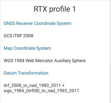
So, I am testing out Trimble's RTX Field Point product as an alternative. The fix time is anywhere from 2 to 5 minutes. The horizontal accuracy reported back is generally 3.9 inches. The mobile device is a samsung galaxy S8. My web map layers have a WKID projection of 3857. So I set the collector for ArcGIS (classic) location profile as:
GNSS Receiver Coordinate System: GCS ITRF 2008
Map Coordinate System: WGS 1984 Web Mercator Auxiliary Sphere
Datum Transformation: itrf_2008_to_nad_1983_2011 + wgs_1984_(itrf08)_to_nad_1983-2011
When I bring the points collected while using Trimble's RTX field point product into ArcPro they (green pts) are all consistently shifted west and south to the survey points (yellow). This leads me to think that I am not doing something right rather than an issue with the unit or the RTX. Attached is a screen shot of the location profile and of the points compared to the surveyed location with a one foot buffer. I am thinking it may be the profile, but I am not sure what else to use.
If anyone has an idea of what is going on, I would really appreciate your thoughts, ideas and suggestions.
- Mark as New
- Bookmark
- Subscribe
- Mute
- Subscribe to RSS Feed
- Permalink
- Report Inappropriate Content
May I suggest the ultimate way to solve this dilemma. Its called Whack a Mole. Unless you occupy survey control,that is in the datum of which you seek to be tied too, you will chase this till the cows come home.
Surveyors, the expert measurement experts will tell a GIS guy/gal - to Check in. This means to see how close your system, software, incoming augmentation and all the datum gates in Pro/ArcGIS/Map/FS/Location Profile/Quality of GPS take into effect have on becoming "accurate".
Check into a Control point using a nearby benchmark using OPUS shared (google) or NGS Explorer (google). Find a point that is reporting its coordinates in, I'm guessing with your situation as NAD83 (2011). Setup on that point with your system, do what you think is best and see how close you get too that point using best practices. Look up the specs of the device. If it says 20cm, subfoot, you should get there. If your not, then one of the datum gates you selected is wrong. Or more.
Good Luck.
- « Previous
-
- 1
- 2
- Next »
- « Previous
-
- 1
- 2
- Next »