- Home
- :
- All Communities
- :
- Products
- :
- ArcGIS Collector
- :
- ArcGIS Collector Questions
- :
- Project Z
- Subscribe to RSS Feed
- Mark Topic as New
- Mark Topic as Read
- Float this Topic for Current User
- Bookmark
- Subscribe
- Mute
- Printer Friendly Page
- Mark as New
- Bookmark
- Subscribe
- Mute
- Subscribe to RSS Feed
- Permalink
I am trying to use the Project Z tool in ArcGIS pro but it is never prompting for the Geoid12B transformation. Is this something that needs downloaded and imported into pro? We have tried with meters then converted to ft. In collector our RTK correction is broadcasting in WGS 84 and our Collector Map is in WGS 84. We are trying to projectz to NAD83 2011 and NAVD88.
Solved! Go to Solution.
Accepted Solutions
- Mark as New
- Bookmark
- Subscribe
- Mute
- Subscribe to RSS Feed
- Permalink
Mark,
The reason no transformation options are available is the combination of settings you have input do not have a transformation path.
ProjectZ is intended to convert the Latitude, Longitude and Altitude values collected from a GPS back into 3D points and convert the Altitude (Height Above Ellipsoid) into Elevation values. The Latitude, Longitude and Altitude values stored from Collector are in the raw GPS data format you are utilizing. For example, I am using a State VRS system that utilizes NAD 1983 (2011) for both horizontal and vertical.
These are set in ProjectZ as follows for the Input Coordinate System:
Click on the Globe next to the input box
Click on the Current XY box then select:
Geographic coordinate system > North America > USA and territories > NAD 1983 (2011)
Click on the Current Z box and select:
Vertical Coordinate System > Ellipsoidal-based > North America > NAD 1983 2011
Click OK
You will need to determine your coordinate system being utilized by yout GPS and apply the same. If you are using WGS84 I would guess you could try the following.
Click on the Globe next to the input box
Click on the Current XY box then select:
Geographic coordinate system > World > WGS 1984
Click on the Current Z box and select:
Vertical Coordinate System > Ellipsoidal-based > World > WGS 1984
Click OK
Set your X, Y and Z fields and output Feature Class
For you Output coordinate system it is the simular
Click on the Globe next to the input box
Click on the Current XY box then select:
Projected coordinate system > State Plane > Your system > Your state system
Click on the Current Z box and select:
Vertical Coordinate System > North America > NAVD 1988 - Do not select NAVD88 (height) (ftUS) at this point.
Click OK
Note: You cannot transform directly to NAVD88 (height) (ftUS).
Run the ProjectZ
Once this completes, you can run a Project on the new feature class to go from NAVD 1988 to NAVD88 (height) (ftUS) using the same XY coordinate system.

This is explained in more detail in the post I noted previously. Is it possible to collect accurate Z coordinate values with Collector and Trimble R2?
- Mark as New
- Bookmark
- Subscribe
- Mute
- Subscribe to RSS Feed
- Permalink
Mark,
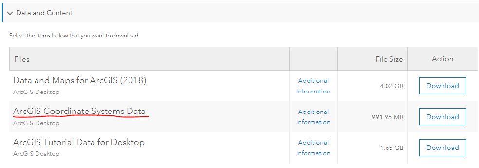
Yes, you need to download and install the ArcGIS Coordinates System Data from ESRI. It is available from my.esri under downloads. Select Desktop or Pro then click View Downloads. Scroll down a bit and you will see it under Data and Content.
You can also take a look at Is it possible to collect accurate Z coordinate values with Collector and Trimble R2? for some more details on using ProjectZ.
One tip, it is not possible to directly translate to NAVD88 (height)(ftUS). Convert to NAVD 1988 using ProjectZ then run just a Project Tool to NAVD88 (height)(ftUS). This is outlined in the post noted above.
- Mark as New
- Bookmark
- Subscribe
- Mute
- Subscribe to RSS Feed
- Permalink
I have downloaded and installed, but still not prompted with a GEOID. What is the altitude value vertical system that I am suppose to be choosing for the Input WGS 84 data. I know it is meters and ellipsoidal height, but not sure on what I am going to choose for vertical input. I want to go to state plane and NAVD88 ft for output, as soon as I select NAVD88 for the output vertical it removes the horizontal transformation and no options are available for transformation.
Thanks
Mark Yerington │GIS Manager│ GISP
Muscatine Area Geographic Information Consortium
c/o Muscatine Power & Water | 3205 Cedar Street | Muscatine, IA 52761
Office: 563.262.3316│Cell: 563.260.4525 Email: [email protected]│Web: magic-gis.com<https://magic-gis.com/>
- Mark as New
- Bookmark
- Subscribe
- Mute
- Subscribe to RSS Feed
- Permalink
Mark,
The reason no transformation options are available is the combination of settings you have input do not have a transformation path.
ProjectZ is intended to convert the Latitude, Longitude and Altitude values collected from a GPS back into 3D points and convert the Altitude (Height Above Ellipsoid) into Elevation values. The Latitude, Longitude and Altitude values stored from Collector are in the raw GPS data format you are utilizing. For example, I am using a State VRS system that utilizes NAD 1983 (2011) for both horizontal and vertical.
These are set in ProjectZ as follows for the Input Coordinate System:
Click on the Globe next to the input box
Click on the Current XY box then select:
Geographic coordinate system > North America > USA and territories > NAD 1983 (2011)
Click on the Current Z box and select:
Vertical Coordinate System > Ellipsoidal-based > North America > NAD 1983 2011
Click OK
You will need to determine your coordinate system being utilized by yout GPS and apply the same. If you are using WGS84 I would guess you could try the following.
Click on the Globe next to the input box
Click on the Current XY box then select:
Geographic coordinate system > World > WGS 1984
Click on the Current Z box and select:
Vertical Coordinate System > Ellipsoidal-based > World > WGS 1984
Click OK
Set your X, Y and Z fields and output Feature Class
For you Output coordinate system it is the simular
Click on the Globe next to the input box
Click on the Current XY box then select:
Projected coordinate system > State Plane > Your system > Your state system
Click on the Current Z box and select:
Vertical Coordinate System > North America > NAVD 1988 - Do not select NAVD88 (height) (ftUS) at this point.
Click OK
Note: You cannot transform directly to NAVD88 (height) (ftUS).
Run the ProjectZ
Once this completes, you can run a Project on the new feature class to go from NAVD 1988 to NAVD88 (height) (ftUS) using the same XY coordinate system.
This is explained in more detail in the post I noted previously. Is it possible to collect accurate Z coordinate values with Collector and Trimble R2?
- Mark as New
- Bookmark
- Subscribe
- Mute
- Subscribe to RSS Feed
- Permalink
Lance
Thank you the hey was selecting NAVD88 only and everything worked as expected. I had just got this completed a few minutes ago
Thanks