- Home
- :
- All Communities
- :
- Products
- :
- ArcGIS Collector
- :
- ArcGIS Collector Questions
- :
- Re: New IOS Collector App Problems
- Subscribe to RSS Feed
- Mark Topic as New
- Mark Topic as Read
- Float this Topic for Current User
- Bookmark
- Subscribe
- Mute
- Printer Friendly Page
- Mark as New
- Bookmark
- Subscribe
- Mute
- Subscribe to RSS Feed
- Permalink
Has anyone had any problems with version 10.3.5 of Collector (released on October 18th)? Since the update we have not had the ability to edit existing features. We are using a portal based service with feature access. It will allow us to add new points, but not edit existing points. We have tried everything but are stumped. In the portal we are able to edit and add points as always, so permissions is not the issue.
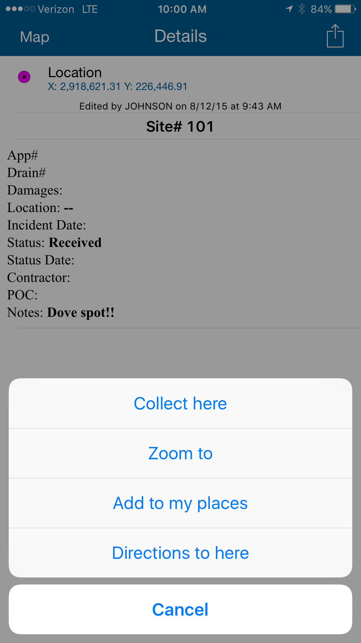
Below you can see a screen shot. When you select a point, then click on the upper right button it gives this menu. There used to be an option to edit it here, but it does not show up any more. Help!!!
Solved! Go to Solution.
Accepted Solutions
- Mark as New
- Bookmark
- Subscribe
- Mute
- Subscribe to RSS Feed
- Permalink
This is now resolved. I still do not know why the feature service that was working fine stopped working, BUT I took the same MXD file I used to create that service and created a new one. O then created a new map for the new service and shared it appropriately. The feature service is now editable.
- Mark as New
- Bookmark
- Subscribe
- Mute
- Subscribe to RSS Feed
- Permalink

Maybe "Editors can only update and edit the features they add" option is checked for your feature service?
- Mark as New
- Bookmark
- Subscribe
- Mute
- Subscribe to RSS Feed
- Permalink
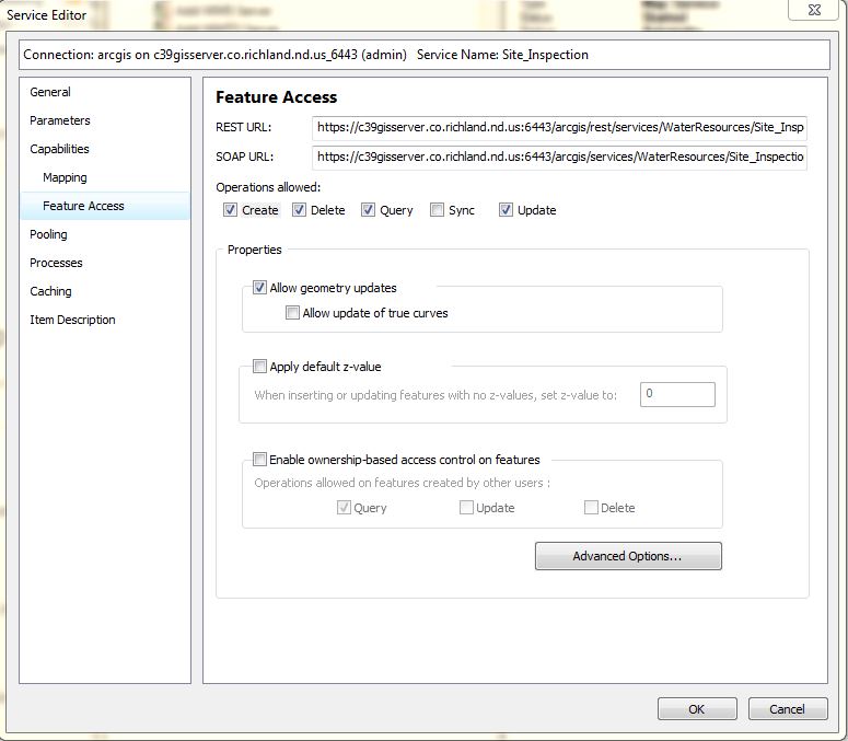
Hello. Thanks for taking an interest in our problem. Almost all of the features are added and edited by the same person, so I don't think that is it. But here is a look at the feature properties (I don't see that option):
- Mark as New
- Bookmark
- Subscribe
- Mute
- Subscribe to RSS Feed
- Permalink
The corresponding option in your screenshot is "Enable ownership-based access control on feature" . It is unchecked. Probably ownership based accession is not the reason.
Can you go to your feature service REST end point and check the json. The URL looks like
[Server URL]/arcgis/rest/services/[Service Name]/FeatureServer?f=pjson
You should see something like:
{
"currentVersion": 10.3,
"serviceDescription": "test",
"hasVersionedData": true,
"supportsDisconnectedEditing": true,
"syncEnabled": true,
"syncCapabilities": {
"supportsRegisteringExistingData": true,
"supportsSyncDirectionControl": true,
"supportsPerLayerSync": false,
"supportsPerReplicaSync": true,
"supportsRollbackOnFailure": false,
"supportsAsync": true,
"versionCreationRule": "versionPerUser"
},
"supportedQueryFormats": "JSON, AMF",
"maxRecordCount": 1000,
"capabilities": "Create,Delete,Query,Sync,Update,Uploads,Editing",
"description": "",
"copyrightText": "",
"spatialReference": {
"wkid": 4326,
"latestWkid": 4326
},
Look at capabilities and you should have Update, .etc.
- Mark as New
- Bookmark
- Subscribe
- Mute
- Subscribe to RSS Feed
- Permalink
{
"currentVersion": 10.31,
"serviceDescription": "Service used by Water Resources to Update Site Inspections",
"hasVersionedData": true,
"supportsDisconnectedEditing": true,
"syncEnabled": false,
"supportedQueryFormats": "JSON, AMF",
"maxRecordCount": 1000,
"capabilities": "Create,Delete,Query,Update,Uploads,Editing",
"description": "",
"copyrightText": "",
"spatialReference": {
"wkid": 102721,
"latestWkid": 102721
},
"initialExtent": {
"xmin": 2784795.9737791843,
"ymin": 235321.56882762923,
"xmax": 2945863.6821125173,
"ymax": 311233.02716096246,
"spatialReference": {
"wkid": 102721,
"latestWkid": 102721
}
},
"fullExtent": {
"xmin": 2782280.6834204644,
"ymin": 134916.41724413633,
"xmax": 2963682.2011941373,
"ymax": 507381.2018406391,
"spatialReference": {
"wkid": 102721,
"latestWkid": 102721
}
},
"allowGeometryUpdates": true,
"units": "esriFeet",
"documentInfo": {
"Title": "",
"Author": "",
"Comments": "",
"Subject": "",
"Category": "",
"Keywords": "Water Resources,Site Inspections,Drains"
},
"layers": [
{
"id": 0,
"name": "Inspection Sites"
},
{
"id": 1,
"name": "Vegetation"
}
],
"tables": [],
"enableZDefaults": false
}
- Mark as New
- Bookmark
- Subscribe
- Mute
- Subscribe to RSS Feed
- Permalink
You can try to add the feature service again into your portal webmap and ArcGIS Online webmap. If the issue still exist, you can contact Esri Support to have a support case logged so you can work with support analysts to troubleshoot the issue.
- Mark as New
- Bookmark
- Subscribe
- Mute
- Subscribe to RSS Feed
- Permalink
We have already attempted both of these things.
- Mark as New
- Bookmark
- Subscribe
- Mute
- Subscribe to RSS Feed
- Permalink
This is now resolved. I still do not know why the feature service that was working fine stopped working, BUT I took the same MXD file I used to create that service and created a new one. O then created a new map for the new service and shared it appropriately. The feature service is now editable.
- Mark as New
- Bookmark
- Subscribe
- Mute
- Subscribe to RSS Feed
- Permalink
It is great to hear that. Thanks for the update.