- Home
- :
- All Communities
- :
- Products
- :
- ArcGIS Collector
- :
- ArcGIS Collector Questions
- :
- GNSS Reciever. Datum Shift. Bug in Collector Coord...
- Subscribe to RSS Feed
- Mark Topic as New
- Mark Topic as Read
- Float this Topic for Current User
- Bookmark
- Subscribe
- Mute
- Printer Friendly Page
GNSS Reciever. Datum Shift. Bug in Collector Coordinate System Transformations.
- Mark as New
- Bookmark
- Subscribe
- Mute
- Subscribe to RSS Feed
- Permalink
Just recently purchased Trimbles new TDC150 GNSS Handheld. We were using their Geo7x but wanted a more simple workflow. So instead of getting built in software for the unit we opted instead to use Collector. With our correction service we consistently get 4-10 cm, which is awesome by the way, however in it's maiden voyage I found that everything was off. All my features in ArcGIS online were 1m off and NW from me, consistently.
Our correction service uses GCS NAD 1983 (2011). So, following the recommended transformations made online and by esri we set up a location profile that only got us .1m closer. Discovering there was a supposed bug with the normal ITRF00/ ITRF08 transformations we were told to use "NAD_1983_HARN_to_NAD_1983_2011 + NAD_1983_HARN_to_WGS_1984 [USA (all states) + USA – HARN]". This unfortunately only brought us down to .5m.
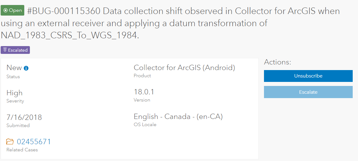
We used every optional transformation given our location and coordinate system used by our correction service. Some maintained .5m others took us to 1.5m, some stayed NW of us others went SE. Finally we called Esri Support services and after a brief moment of investigating existing bugs they found one. The bug is in the transformations and when I looked at the original submitted bug my case is attached to, it was originally submitted July...of 2018!
I asked what the time frame would be to correct this, a few weeks or months? They couldn't say. It's really frustrating because from what I see this is not very reassuring that anyone is working on a resolution for this.
collector issues coordinate system projection datum shift datum transformations high accuracy gnss

- Mark as New
- Bookmark
- Subscribe
- Mute
- Subscribe to RSS Feed
- Permalink
Hi David -- I looked into this a bit and unfortunately I don't have much to report back on it. However, I'd recommend testing if this is still an issue for you in the beta available now for the upcoming release of the Android app. To get the beta app, join our Collector Early Adopter community so you’ll have the latest information on what you can test as well as provide feedback. Once you’ve joined, visit Getting Started to access the beta release for Android.
- Mark as New
- Bookmark
- Subscribe
- Mute
- Subscribe to RSS Feed
- Permalink
Thanks for checking it out. So, an update, vendor we purchased our new unit from has been working on figuring out whats wrong too and brought in Trimble. They had me run a now successful test to see what the fix should be. I collected a point with the Geo7x with the RTK network enabled (NAD1983 2011) and then exported it to a shapefile with a
WGS 1983
Projection file I uploaded it to AGO and added it to my Field Collections Map and would't you know it I'm right on top of it. I still had the location profile set up as this:
GNSS Receiver Coordinate System - GCS NAD 1983 2011
Map Coordinate System - WGS 1984 Web Mercator Auxiliary Sphere
Datum Transformation - wgs_1984_(itrf00)_to_nad_1983_2011
So now my question is this. The rest of my feature layers in our portal are off the same as before. How do I get my data projected in WGS 1983 (not 84)?