- Home
- :
- All Communities
- :
- Products
- :
- ArcGIS Collector
- :
- ArcGIS Collector Questions
- :
- Re: Create a collector app that only allows users ...
- Subscribe to RSS Feed
- Mark Topic as New
- Mark Topic as Read
- Float this Topic for Current User
- Bookmark
- Subscribe
- Mute
- Printer Friendly Page
Create a collector app that only allows users to edit a certain field?
- Mark as New
- Bookmark
- Subscribe
- Mute
- Subscribe to RSS Feed
- Permalink
Is there a way to create a Collector app that only allows users to edit a certain field? I would like to create an app for our contractors to use and have them change a "Status" field to "Completed" on task records, but I do not want them to be able to edit any other data. Even though the service I will use is a copy of the real data, I would like to add that extra protection to assure that we get accurate information returned.
Solved! Go to Solution.
Accepted Solutions
- Mark as New
- Bookmark
- Subscribe
- Mute
- Subscribe to RSS Feed
- Permalink
Hi Kaitlyn - Yes, it is up to you what fields are editable. There are a few ways to accomplish this.
1. Set the editability as part of your service -- how you do this depends on how/where you are creating the service.
2. Set it in the web map (although if set in the web map, then the same data could be edited if added to a different map). Details on this are here: Configure the form > Display and editability of entries—Collector for ArcGIS | Documentation
3. Use feature layer views: Control access to data in Collector through feature layer views).
- Mark as New
- Bookmark
- Subscribe
- Mute
- Subscribe to RSS Feed
- Permalink
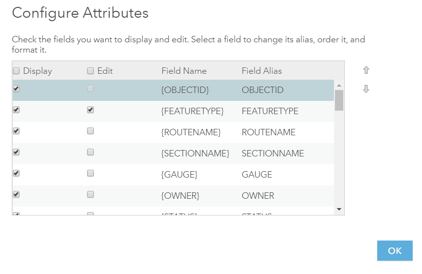
Hi Kaitlyn,
The fields your contractors see/edit in Collector are those that are available through the popup.
In the web map, open the layer's popup and set the appropriate Display/Edit. For example, in the image below all layers are visible but only FEATURETYPE is editable:
Hope this helps,
Uri
If this answer solved your question or if you found it helpful please mark it accordingly to help others who have the same question.
- Mark as New
- Bookmark
- Subscribe
- Mute
- Subscribe to RSS Feed
- Permalink
Awesome thank you so much, both of you!! That is very helpful!