- Home
- :
- All Communities
- :
- Products
- :
- ArcGIS Collector
- :
- ArcGIS Collector Questions
- :
- Re: Cordinate systems and transformations with col...
- Subscribe to RSS Feed
- Mark Topic as New
- Mark Topic as Read
- Float this Topic for Current User
- Bookmark
- Subscribe
- Mute
- Printer Friendly Page
Cordinate systems and transformations with collector and high accuracy GNSS GPS - best practice
- Mark as New
- Bookmark
- Subscribe
- Mute
- Subscribe to RSS Feed
- Permalink
- Report Inappropriate Content
We have been testing a high accuracy GNSS GPS with Collector (Aurora and 18.0.1) in a development environment and utilizing ArcGIS online as our Portal. As we plan to move to the production environment questions have arose pertaining to minimizing data translations to maintain accuracy. The GPS utilizes and outputs in the GCS NAD 1983 2011 coordinate system from our State VRS network. We have been translating this to WGS 1984 Web Mercator Auxiliary Sphere for use with ArcGIS Online and its related basemaps. Our production system also utilizes the GCS NAD 1983 2011 coordinate system, specifically the NAD 1983(2011) State Plane and no translations are needed between the GPS and production servers; however, we plan on continuing to utilize ArcGIS online as our Portal for collector. What is the best or recommend approach to maintain the collected coordinate data accuracy?
We are considering:
1) generating our own basemaps on our local servers using the GCS NAD 1983 2011 coordinate system and pushing these up to ArcGIS online and sideloading them directly onto our Collector systems (when/if they will fit). This would save on credits used for building the tiles but we will still be utilizing credits for storage. Subsequently, we would publish our features utilizing the same coordinate system. This is currently our preferred approach as there would not be any translations required.
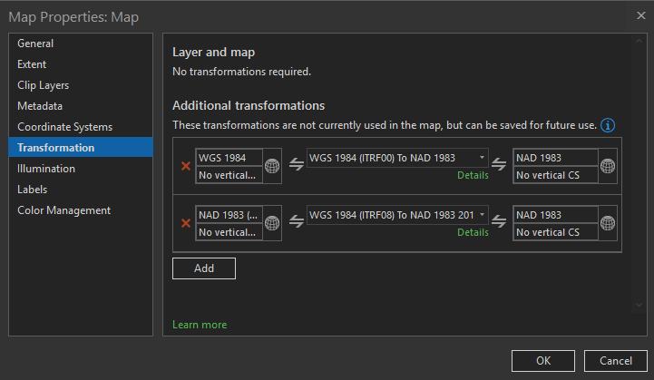
2) continue with the current approach of collecting GPS data using GCS NAD 1983 2011, translating to WGS 1984 Web Mercator Auxiliary Sphere on ArcGIS Online and then translating back to the NAD 1983(2011) State Plane we utilize internally. We have noted a definite shift in the data collected utilizing this method when compared to data collected by our surveyor utilizing a total station or survey grade GPS on our own local network. I have experimented with different translations but the WGS_1984_(ITRF08) to NAD_1983_2011 we are utilizing provides the best match.
3) a question for the ESRI team is it possible to utilize the ArcGIS online basemaps without Collector automatically using the WGS 1984 Web Mercator. We did try and publish a feature using the GCS NAD 1983 2011 coordinate system but the Maps/Collector automatically adopts the basemap coordinate system. We were also not positive on how the point data was being handled with a mixed coordinate system and most likely introducing further translations and potential errors.
It is ironic that a few years ago GIS data that was accurate to a couple of meters we considered fantastic and now we are looking at a target accuracy of 10cm and achieving an actual accuracy of less then 2cm
Solved! Go to Solution.
- Mark as New
- Bookmark
- Subscribe
- Mute
- Subscribe to RSS Feed
- Permalink
- Report Inappropriate Content
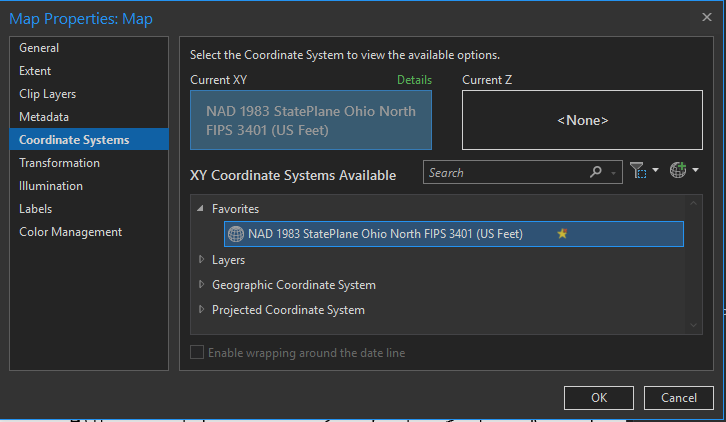
Unfortunately, I do not know of any supporting documentation for transformations. I typically start by positively confirming the coordinate system of the source data and using a known reference to confirm the proper transformation. Experiment using a logical progression the system would have undergone until you find a transformation combination that works. The process can be a challenge, especially from an older system to a newer system.
On a side note, the transformations listed in ArcGIS are typically in the order of most likely to least likely. Provided you have set your map to the desired coordinate system.
Sorry, I did not have any data available on my home system to demo correctly.
To confirm you have ArcGIS Coordinate Systems Data installed you can look in the installed programs. It will be listed as noted in the screenshot below. This is a separate install from ArcGIS Pro and 10.9 is the most recent for both Desktop and Pro.
- Mark as New
- Bookmark
- Subscribe
- Mute
- Subscribe to RSS Feed
- Permalink
- Report Inappropriate Content
If anyone is having this issue capturing Field Maps height data in the UK we have a custom service that performs the vertical transformation in real time using the OSGM15 transformation, see our Z-Transform solution page here - https://mgiss.co.uk/z-transform/
- « Previous
- Next »
- « Previous
- Next »


