Turn on suggestions
Auto-suggest helps you quickly narrow down your search results by suggesting possible matches as you type.
Cancel
- Home
- :
- All Communities
- :
- Products
- :
- ArcGIS CityEngine
- :
- ArcGIS CityEngine Questions
- :
- Re: Shapefile and image mismatch
Options
- Subscribe to RSS Feed
- Mark Topic as New
- Mark Topic as Read
- Float this Topic for Current User
- Bookmark
- Subscribe
- Mute
- Printer Friendly Page
Shapefile and image mismatch
Subscribe
7561
8
01-19-2012 04:22 AM
01-19-2012
04:22 AM
- Mark as New
- Bookmark
- Subscribe
- Mute
- Subscribe to RSS Feed
- Permalink
Hi
I'm attempting to use CityEngine 2011 to create a model of Singapore. I have a satellite image of the downtown area of Singapore along with a shapefile containing the road networks. Both are in WGS84 UTM zone 48N projection and when viewed in ArcMap they correlate perfectly. However, when I import them into CityEngine they end up seperated by about 400km and 90 degrees rotation. I can use the map offset to bring the map layer into the same area as the shapefile road network but can do anything about the rotation. I guess I therefore have 2 questions:
1. Why don't the two sets of data correlate correctly in CityEngine?
2. Is there any way I can rotate the map layer so I can at least get the image and the road network data lined up?
Thanks.
8 Replies
01-20-2012
07:04 AM
- Mark as New
- Bookmark
- Subscribe
- Mute
- Subscribe to RSS Feed
- Permalink
Dear Paul,
Is it possible that you can provide me with a test dataset on which you can reproduce the issue which you can share ?
Please let me know.
Is it possible that you can provide me with a test dataset on which you can reproduce the issue which you can share ?
Please let me know.
01-25-2012
12:30 AM
- Mark as New
- Bookmark
- Subscribe
- Mute
- Subscribe to RSS Feed
- Permalink
Hi Matthias
I was preparing some data to send you but decided to use a jpg with a prj file rather than a geotiff so that the data size was reduced. I did a test import just to make sure the error was reproduced and it worked! I guess I'll use that method instead. Easy really.
Thanks
Paul
I was preparing some data to send you but decided to use a jpg with a prj file rather than a geotiff so that the data size was reduced. I did a test import just to make sure the error was reproduced and it worked! I guess I'll use that method instead. Easy really.
Thanks
Paul
02-06-2013
10:19 AM
- Mark as New
- Bookmark
- Subscribe
- Mute
- Subscribe to RSS Feed
- Permalink
I'm experiencing exactly the same problem.
If I use the GeoTiff this one is far away from the shp street network, if I use a PNG the location matches but the scale it does not (the map is smaller in the orther of 10 times).
As we have a server license, I have tried anything I could: I used different data, different machines (Win xp or Win 7) or different ArcMap versions (10 or 10.1). Problem was the same.
It is the main feature we expected to use in CityEngine, I hope there is a way to solve this problem.
Thank You
Damiano Cerrone
Spin Unit
02-07-2013
04:52 AM
- Mark as New
- Bookmark
- Subscribe
- Mute
- Subscribe to RSS Feed
- Permalink
Hi Damiano !
If both datasets are georeferenced, they should match the same position .. so hmmm...
Try using the exact same projection for both shape file and raster file. Means make sure all data and terrain images match the target SCS ( Scene Coordinate System ) in the CityEngine scene file.
If you already tried this, can you send me the test data ?
Lemme know.
Matt
02-07-2013
11:13 AM
- Mark as New
- Bookmark
- Subscribe
- Mute
- Subscribe to RSS Feed
- Permalink
Thank You for answering in short time.
I have just cleared this issue, false alarm:
My routine was to create a project in CE then copying the files produced in ArcGis onto CE workspace by drag/drop as you can see in the attached image.
Due of my intense use of ArcCatalog, my mind was giving for granted that this drag/drop action was carrying along also projection files together with the images, thought it doesn't
I tried to copy the files directly into the folder with Win explorer and off course it worked.
Damiano[ATTACH=CONFIG]21583[/ATTACH]
02-11-2013
12:43 AM
- Mark as New
- Bookmark
- Subscribe
- Mute
- Subscribe to RSS Feed
- Permalink
hi !
great to hear it works now !
m.
great to hear it works now !
m.
10-02-2016
02:55 PM
- Mark as New
- Bookmark
- Subscribe
- Mute
- Subscribe to RSS Feed
- Permalink
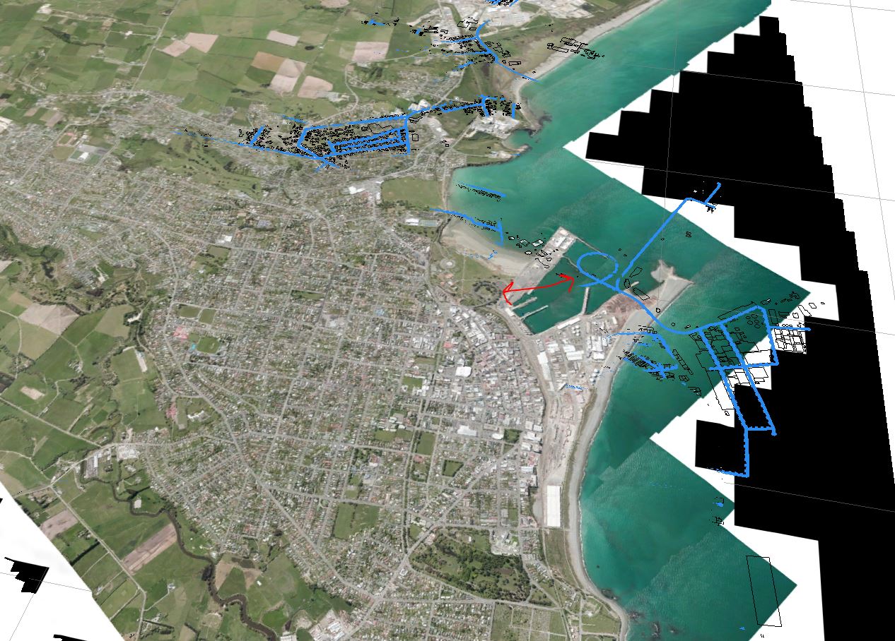
Hi ,
I am also having this issue with CityEngine. My terrain layer does not align with my roads or building layers despite them aligning in Arcmap. I have made sure that all layers are in the same coordinate system (NZTM). I have made sure that they are the same extent. I have tried using Shapefiles to see if that would help.
I have inserted a screenshot of the issue, with the red arrows indicating the difference.
I'm a bit stumped as to what to try next. If someone could give me some suggestions, it would be greatly appreciated.
Thanks
-Amanda

10-02-2016
07:27 PM
- Mark as New
- Bookmark
- Subscribe
- Mute
- Subscribe to RSS Feed
- Permalink
After tweaking some more I worked out that the Aerial photo was the cause. It wasn't quite the same extent and I re did it completely which resulted in it working. Thanks anyway 