Turn on suggestions
Auto-suggest helps you quickly narrow down your search results by suggesting possible matches as you type.
Cancel
- Home
- :
- All Communities
- :
- Products
- :
- ArcGIS CityEngine
- :
- ArcGIS CityEngine Questions
- :
- re-model ???non-textured??? 3D feature class into ...
Options
- Subscribe to RSS Feed
- Mark Topic as New
- Mark Topic as Read
- Float this Topic for Current User
- Bookmark
- Subscribe
- Mute
- Printer Friendly Page
re-model ???non-textured??? 3D feature class into ???textured??? 3D
Subscribe
6368
11
02-19-2012 06:38 PM
02-19-2012
06:38 PM
- Mark as New
- Bookmark
- Subscribe
- Mute
- Subscribe to RSS Feed
- Permalink
Hi, CE team & all
First of all, thanks for prompt reply and help on this forum. Secondly, quick question seeking for your assistance.
We have many existing ???non-textured??? 3D feature classes (multipatch) in geodatabase. Right now, we are trying to modify/re-model ???non-textured??? ones into ???textured??? 3D models, which want to take advantage of CE (I am using CE 2011.1).
Can CE team or anyone else share your hands-on practice on this aspect? It may include:
[INDENT]1. What is the exact procedure to get it done properly in order to obtain ???textured??? 3D feature class from 'non-textured'?
2. Within CE, is it possible to 'directly' use surface textures from referenced images, photos, samples libraries, or CGA rules, in particular, for photorealistic modeling? If yes, how?
[/INDENT]
11 Replies
02-20-2012
06:43 AM
- Mark as New
- Bookmark
- Subscribe
- Mute
- Subscribe to RSS Feed
- Permalink
hi !
this is possible.
though as I remember right, there's still a few issues when reading multiPatches in the CE. I think in 2011.1 it was only possible to read multiPatches from shape files, not FGDB.
maybe it's easiest that you post one or 2 representative buildings as a shapeFile, so I can show you the workflow based on your needs and questions, ok ?
02-20-2012
06:47 PM
- Mark as New
- Bookmark
- Subscribe
- Mute
- Subscribe to RSS Feed
- Permalink
Thanks, Matthias
It sounds great to me. Certainly, CE will add good values to our current 3D workflow, if it works for this circumstance.
Anyhow, considering few of 3D features not enough to present an operational & reliable workflow, I attach tens of 3D buildings for you to explore.
So, as first step, please help try the easiest steps with CE for any 'textured' 3D.
Secondly, it would be nice to use the textures from 'referenced' images. The enhanced workflow should include that, if possible.
+++++++++++
Note,
It is better to open it in ArcGlobe for 'referenced' images. Also, available in ArcGIS Explorer. However, ArcGIS Explorer still does not support 3D display, even though the documentation says so.
Besides, either SHP or GDB is OK, as long as it works, even in 2011.2 or any latest releases.
02-21-2012
12:34 AM
- Mark as New
- Bookmark
- Subscribe
- Mute
- Subscribe to RSS Feed
- Permalink
hi,
do you by chance have this data attributed, which defines which object is what in reality ?
or is it just that geometry without any metadata ?
let me know ..
do you by chance have this data attributed, which defines which object is what in reality ?
or is it just that geometry without any metadata ?
let me know ..
02-22-2012
12:22 AM
- Mark as New
- Bookmark
- Subscribe
- Mute
- Subscribe to RSS Feed
- Permalink
Yes, with this try, no metadata provided.
So, it is good idea to add any attributes, when needed during re-modeling. In other word, it may be a step in your recommended workflow.
(Please refer to the �??referenced�?? images at ArcGlobe (or ArcGIS Explorer) for some info on your needs.)
So, it is good idea to add any attributes, when needed during re-modeling. In other word, it may be a step in your recommended workflow.
(Please refer to the �??referenced�?? images at ArcGlobe (or ArcGIS Explorer) for some info on your needs.)
02-22-2012
03:14 AM
- Mark as New
- Bookmark
- Subscribe
- Mute
- Subscribe to RSS Feed
- Permalink
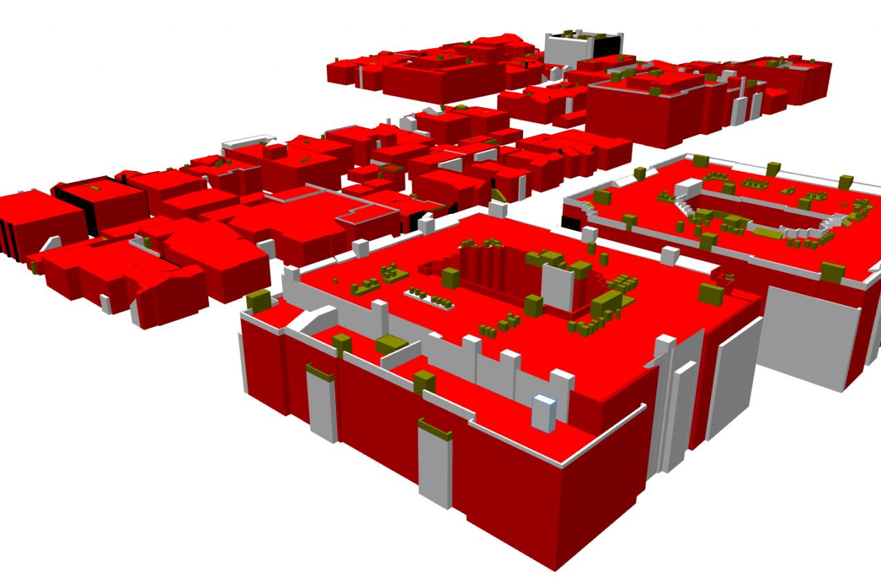
hi Larry.
sadly, I'm not yet very familiar with ArcGIS products .. where do I find those 'referenced�?? images im ArcGlobe ?
* * *
[ATTACH=CONFIG]12114[/ATTACH]
* * *
Okay, let me explain how this workflow would work in the CityEngine, what works and what does not, and what the role of metadata would play.
Read on carefully.. 🙂
1]
First off, the CityEngine can not texture 3d models based on oblique and ortho imagery automatically. So the CE can not 'grab' a 3d multipatch and search the appropriate realworld textures, using e.g. photogrammetric approach. At least at the moment, this is not possible.
2]
The CityEngine is used to texture surfaces (with a series of given input pictures) based on input via code or metadata, which teaches the (dumb) computer what to do with the 'polygon soup'.
Thus, that classification process is of course MUCH easier if you already have the metadata what each object actually represents.
3]
If no metadata is available at all, what you can do - this is seen in the screenshot above - query the dimensions and orientation of each object and 'embed' the metadata by creating your own (code based) classification.
This of course it quite complex and never will catch all possible cases, but can create quite good results, though is of course not representing the real world !
By code-based classification, I mean the following 'tests' for each object:
In pseudo code :
if object is wider and deeper than 5 meters and higher than 3 meters, it's a 'building' or 'room' or a 'garden shed'.
if object is longer than 2 meters, higher than 2 meters and less than 0.5 meters deep, it's a 'wall'.
if objects is less than 1 meters in each dimension, it's a 'technicalBox'
...
After this classification for each object type and continue with testing each of the subshapes (individual polygons) of that object.
E.g. if a volume is classified as 'building', then check the subshapes how they are oriented in space. vertical ones then can be facades with windows, if wide enough.
This breakdown of the process is crude but shows the workflow. Of course - as you see - all that classification can be simplified a lot if the Cityengine already knows what an object actually represents.
Does this make sense ?
An other example :
One customer I've been in contact recently uses a pool of facade images, which has a certain naming convention that defines the buildingID and the facadeIndex. Using this metadata in the file name, the CityEngine can assign a large pool of realworld facade images onto the correct sides of the buildings created based on a 2D GIS dataset.
02-22-2012
04:37 AM
- Mark as New
- Bookmark
- Subscribe
- Mute
- Subscribe to RSS Feed
- Permalink
I have gotten an other input concerning �??ArcGIS Explorer does not support 3D display�?�.
-->
It does�?� Are you using ArcGIS Explorer Online (which is 2D-only), or did you miss the button on the toolbar which switches from 2D to 3D?
-->
It does�?� Are you using ArcGIS Explorer Online (which is 2D-only), or did you miss the button on the toolbar which switches from 2D to 3D?
02-24-2012
09:19 PM
- Mark as New
- Bookmark
- Subscribe
- Mute
- Subscribe to RSS Feed
- Permalink
Thanks a lot for the steps you provided.
First of all, your advice makes sense to me. In fact, I got a little more understanding on what CE â??procedural modelingâ?? does mean ...
Secondly, the snapshot looks better than â??non-textured' 3D, at least, as initial result. I will follow steps carefully and see if I can reproduce your results.
By the way, can you attach the â??remodeledâ?? SHP/KML file that you have done for a comparison? Or directly send the zip file to [email protected]
hi Larry.
sadly, I'm not yet very familiar with ArcGIS products .. where do I find those 'referencedâ?? images im ArcGlobe ?
* * *
[ATTACH=CONFIG]12114[/ATTACH]
* * *
Okay, let me explain how this workflow would work in the CityEngine, what works and what does not, and what the role of metadata would play.
02-24-2012
10:00 PM
- Mark as New
- Bookmark
- Subscribe
- Mute
- Subscribe to RSS Feed
- Permalink
For ArcGlobe, you should have a license of desktop ESRI ArcGIS with the extension �??3D Analyst�?? in your PC workstation.
For ArcGIS Explorer, I am using the official release 1750 from ESRI.
Background:
When the 3D SHP display is tilted, all 3D features should be touched onto the 'surface' without displacement. Correct?
Anyhow, for comparison, those 3D features display correctly in ArcGlobe.
Analysis:
There may have two issues within ArcGIS Explorer for 3D display:
Please open the attached PDF for the details.
+++++++++++++
Honestly, I am not sure if those behavior are bugs in ArcGIS Explorer �??3D itself�?? or bugs associated with '3D feature class'. Anyhow, let others discuss on the forum ArcGIS Explorer
For ArcGIS Explorer, I am using the official release 1750 from ESRI.
Background:
When the 3D SHP display is tilted, all 3D features should be touched onto the 'surface' without displacement. Correct?
Anyhow, for comparison, those 3D features display correctly in ArcGlobe.
Analysis:
There may have two issues within ArcGIS Explorer for 3D display:
- No proper �??tilted�?? display (at least, no good oblique capability) in 3D model;
- All 3D features display in 3D model does not 'properly' recognize heights of 3D feature class and (or) surface;
Please open the attached PDF for the details.
+++++++++++++
Honestly, I am not sure if those behavior are bugs in ArcGIS Explorer �??3D itself�?? or bugs associated with '3D feature class'. Anyhow, let others discuss on the forum ArcGIS Explorer
I have gotten an other input concerning �??ArcGIS Explorer does not support 3D display�?�.
-->
It does�?� Are you using ArcGIS Explorer Online (which is 2D-only), or did you miss the button on the toolbar which switches from 2D to 3D?
02-27-2012
06:22 AM
- Mark as New
- Bookmark
- Subscribe
- Mute
- Subscribe to RSS Feed
- Permalink
hi ..
I personally have no clue yet about those technical 3d display issues, though I'll forward the input and try to post something which helps you at a later time, ok ?
so if you need a quick answer, maybe you ask about this better in the specific esri subforum (explorer related) since this one is dedicated to the CityEngine. 🙂