- Home
- :
- All Communities
- :
- Products
- :
- ArcGIS CityEngine
- :
- ArcGIS CityEngine Questions
- :
- Re: import failed - the data is located too far ?
- Subscribe to RSS Feed
- Mark Topic as New
- Mark Topic as Read
- Float this Topic for Current User
- Bookmark
- Subscribe
- Mute
- Printer Friendly Page
- Mark as New
- Bookmark
- Subscribe
- Mute
- Subscribe to RSS Feed
- Permalink
Hi all !
I have a problem with importing DEM file and osm file together in the same project , i have a DEM file and osm file geolocated perfectly , but when i want to import theme into CityEngine projet i get this error
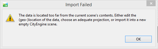
but the files are imported correctly in arcmap , so what's the problem? and how i can fix it ??
Solved! Go to Solution.
Accepted Solutions
- Mark as New
- Bookmark
- Subscribe
- Mute
- Subscribe to RSS Feed
- Permalink
Hello Lahmer Belkacem
Thank you for the data. I had a look at the DEM TIF you provided.
The issue is, that it uses a geographical coordinate system for georeferencing.
Unfortunately CityEngine only supports Cartesian coordinate systems for terrain layers.
Please export the DEM again using "WGS 1984 UTM Zone 31N" coordinates (same as OSM file) for georeferencing.
City Engine Help: Importing Georeferenced Data
"No reprojection nor rotation is applied to image data on import. The image's coordinate system is used only as reference system for location, extent and unit (translate and scale transformation) for the image data during import. It is therefore important to have image data ready in the target coordinate system before importing into CityEngine."
Thomas F
- Mark as New
- Bookmark
- Subscribe
- Mute
- Subscribe to RSS Feed
- Permalink
I have only a tiny bit of knowledge about CityEngine, but some general ideas about coordinate systems. Does the DEM have a defined coordinate system? There are ways that it could overlay in ArcMap without a coordinate system, but not work in CityEngine. What is the DEM's coordinate system?
Melita
- Mark as New
- Bookmark
- Subscribe
- Mute
- Subscribe to RSS Feed
- Permalink
YES both defined coordinate system
- Mark as New
- Bookmark
- Subscribe
- Mute
- Subscribe to RSS Feed
- Permalink
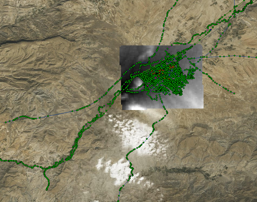
here are the files
- Mark as New
- Bookmark
- Subscribe
- Mute
- Subscribe to RSS Feed
- Permalink
Hello Lahmer Belkacem
Thank you for the data. I had a look at the DEM TIF you provided.
The issue is, that it uses a geographical coordinate system for georeferencing.
Unfortunately CityEngine only supports Cartesian coordinate systems for terrain layers.
Please export the DEM again using "WGS 1984 UTM Zone 31N" coordinates (same as OSM file) for georeferencing.
City Engine Help: Importing Georeferenced Data
"No reprojection nor rotation is applied to image data on import. The image's coordinate system is used only as reference system for location, extent and unit (translate and scale transformation) for the image data during import. It is therefore important to have image data ready in the target coordinate system before importing into CityEngine."
Thomas F
- Mark as New
- Bookmark
- Subscribe
- Mute
- Subscribe to RSS Feed
- Permalink
I have change the files into WGS 1984 UTM Zone 31N but i get the sale error , any help please !
the UTM 31 N file
- Mark as New
- Bookmark
- Subscribe
- Mute
- Subscribe to RSS Feed
- Permalink
thank you i make it hhhhhhhhhhhhh 
- Mark as New
- Bookmark
- Subscribe
- Mute
- Subscribe to RSS Feed
- Permalink
Hi Lahmer,
I have the same problem with you. I alread georeferenced both the DEM and Building footprints in the same cordinate system named "WGS_1984_UTM_Zone_50N". Everything is ok when representing in ArcGIS. However, when I input those data into CityEngine, I got the same error that the data is located too far. Could you please help me to know how to solve this error?
Thank you very much.
- Mark as New
- Bookmark
- Subscribe
- Mute
- Subscribe to RSS Feed
- Permalink
Can you post the extents of these layers?
Thank you,
Melita