- Home
- :
- All Communities
- :
- Products
- :
- ArcGIS CityEngine
- :
- ArcGIS CityEngine Questions
- :
- Re: How to assign height attribute to each grid in...
- Subscribe to RSS Feed
- Mark Topic as New
- Mark Topic as Read
- Float this Topic for Current User
- Bookmark
- Subscribe
- Mute
- Printer Friendly Page
How to assign height attribute to each grid in the grid mesh?
- Mark as New
- Bookmark
- Subscribe
- Mute
- Subscribe to RSS Feed
- Permalink
Hi guys,
These days I have been working on a shapefile which is imported from the ArcGIS (the shapefile is attached below), In the shapefile the whole building is divided into many grids and each grid contain a specific height attribute with it when imported to the CityEngine. As I want to setup a building model according with the geometry grids and its height attribute, so is there any efficient way for me to read each grid height in the CGA rule and assign the specific height for each grid in the building model?

You can see the whole building footprint is divided into a grid mesh, each grid has its own height attribute. How can I assign the different height to different grid for this geometry in CGA rule or through other kind of method?
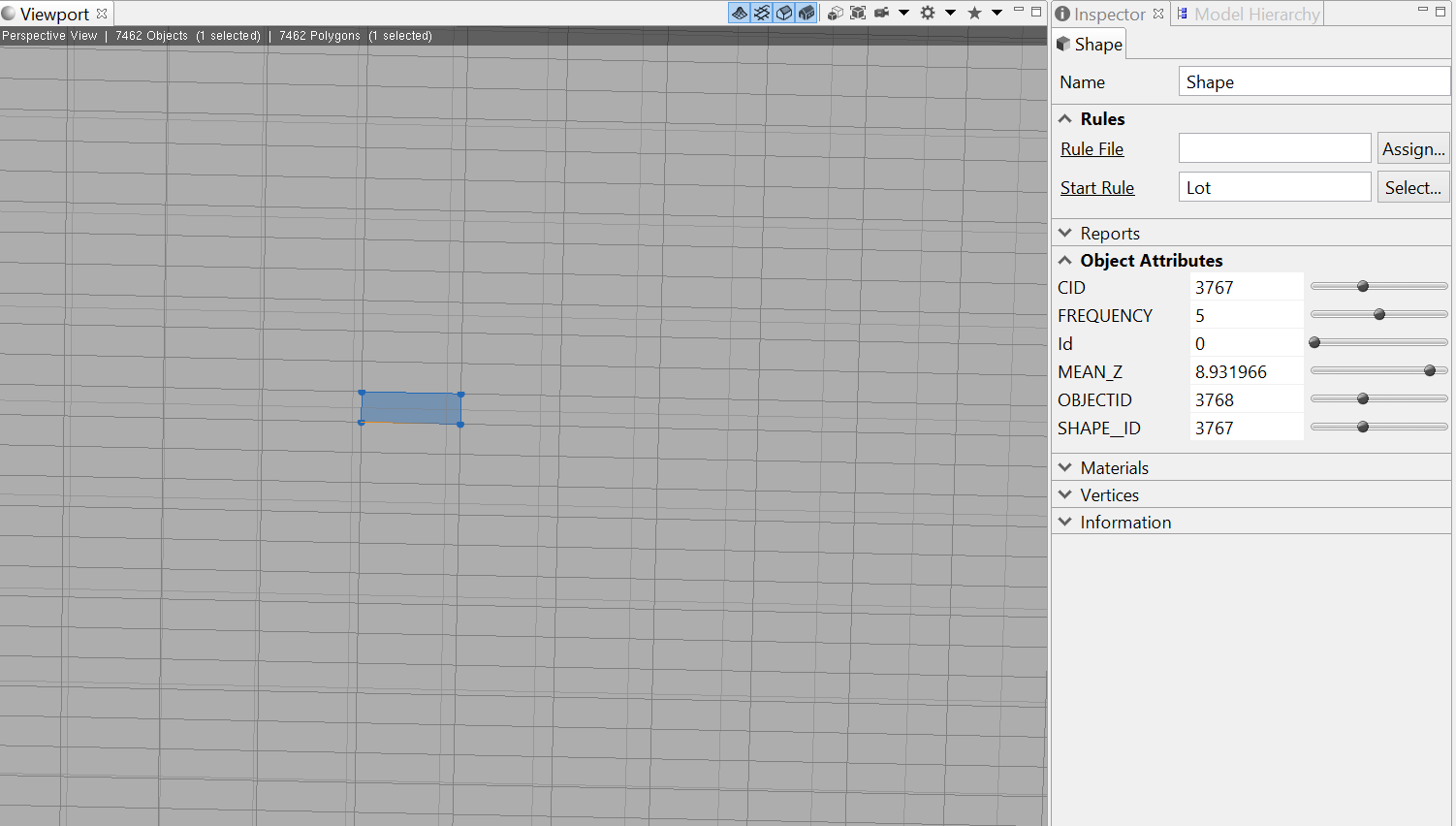
For the selected mesh grid, the MEAN_Z is 8.931966 which is shown in the Object Attributes. Each grid contain this kind of height attribute when it was imported to the CityEngine from ArcGIS.
I'm real confused about this problem. Looking forward for your reply.
Thank you for your help! 
Solved! Go to Solution.
Accepted Solutions
- Mark as New
- Bookmark
- Subscribe
- Mute
- Subscribe to RSS Feed
- Permalink
The CGA code below should do what you want, but be sure and look at other building rules as well and how they work. There are lots of rules out there that can create 3D buildings already.
http://www.arcgis.com/home/item.html?id=4a62343e07c247299d056321b00f059c
attr MEAN_Z = 2
@StartRule
Extruder-->
cleanupGeometry(all,1) #remove this line if you want to keep all the grid vertices in the model
alignScopeToAxes(y)
s('1,0,'1)
extrude(MEAN_Z)
- Mark as New
- Bookmark
- Subscribe
- Mute
- Subscribe to RSS Feed
- Permalink
Hi Micah,
Thank you so much for helping me, and sorry about replying you so late. I have tried the code you gave me, but it does not modify the geometry to what I want. Can the code you gave me read each grid's MEAN_Z attribute from the shapefile automatically and also make the height attribute be assigned to the building model?
With thanks,
Best Regards,
Tianfang Jiang
- Mark as New
- Bookmark
- Subscribe
- Mute
- Subscribe to RSS Feed
- Permalink
Hi Micah,
I think I didn't describe my question very clearly. The shapefile in ArcGIS are the pictures below which can show that the height for each grid is different from each other. And when the shapefile is imported to the CityEngine, the height attribute for each grid is also imported. But I don't know you how to read and assigned each height attribute automatically by the cga code.
Thank you for your patience.
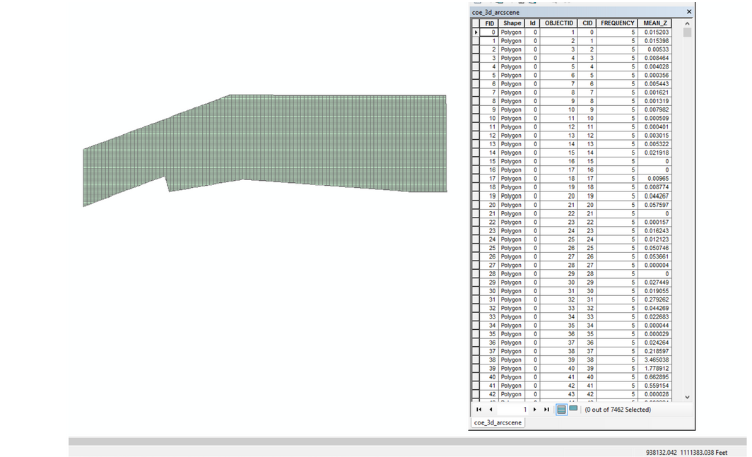
This is the 2-D grid mesh geometry and the table on the right side is the height attribute for each grid:
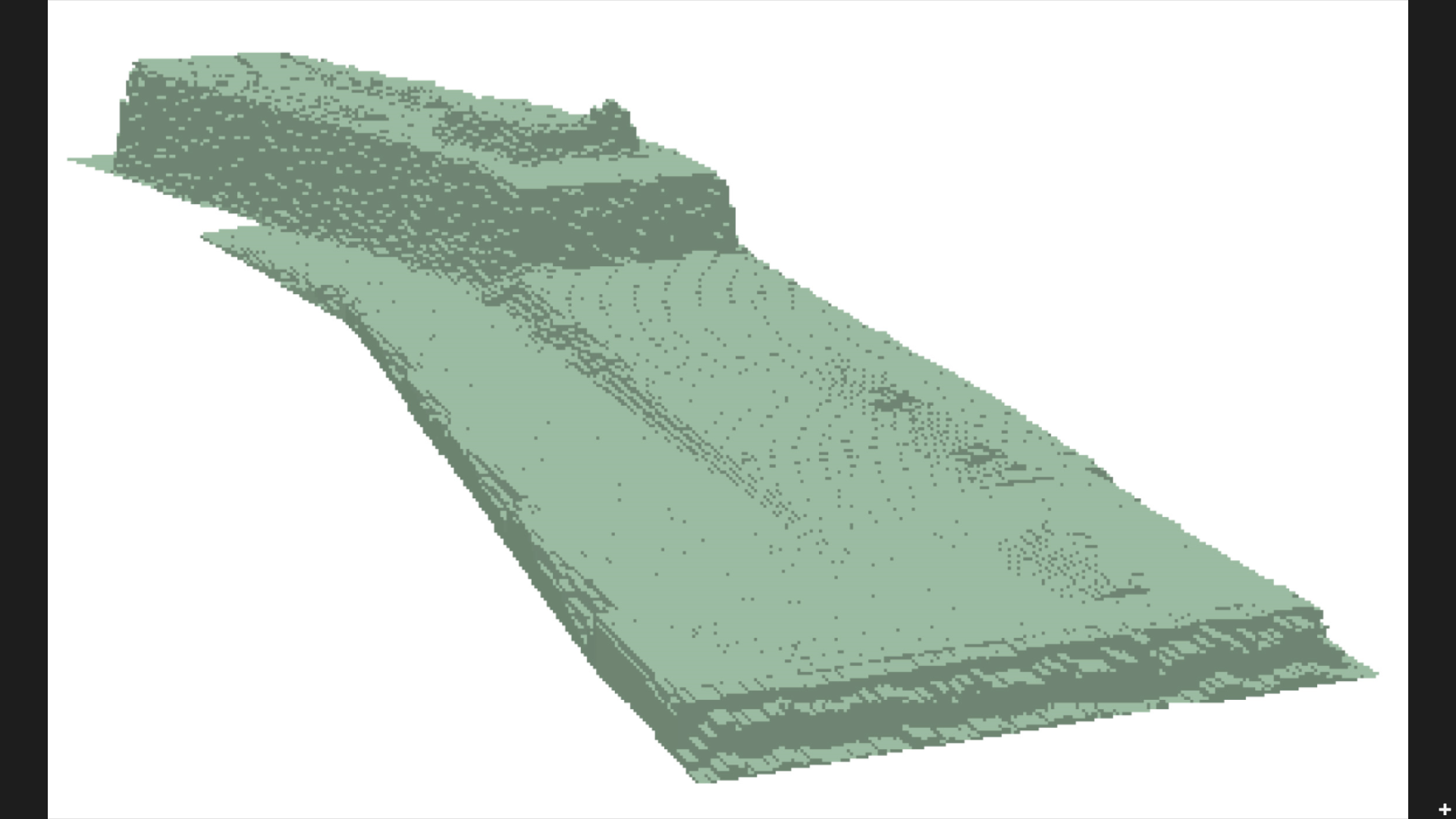
This is the 3-D view of the building I want to build in CityEngine which the height of each grid is different from each other:
With thanks,
Bests,
Tianfang Jiang
- Mark as New
- Bookmark
- Subscribe
- Mute
- Subscribe to RSS Feed
- Permalink
Tianfang,
Try to create a height attribute in the rule file and assign it a random value.
Then take a look at this: http://cehelp.esri.com/help/index.jsp?topic=/com.procedural.cityengine.help/html/manual/attrmap/conn...
-Leilei
- Mark as New
- Bookmark
- Subscribe
- Mute
- Subscribe to RSS Feed
- Permalink
Leilei,
I will try your method. Thank you so much for your help.
Tianfang
Sent from myMail for iOS
Thursday, October 15, 2015, 3:41 PM -0400 from Leilei Duan <geonet@esri.com>:
>GeoNet
>How to assign height attribute to each grid in the grid mesh?
>reply from Leilei Duan in CityEngine - View the full discussion
- Mark as New
- Bookmark
- Subscribe
- Mute
- Subscribe to RSS Feed
- Permalink
I reckon Micah's answer is correct - just be sure that the 'Source for attribute' is set to 'Object attribute' via the Inspector.
- Mark as New
- Bookmark
- Subscribe
- Mute
- Subscribe to RSS Feed
- Permalink
Yes, I think you are right, Micah's answer is right. In the CGA code I just named the attribute as what I want to quote from the object attribute. Then the problem was solved.
Thank you so much for your help!
- Mark as New
- Bookmark
- Subscribe
- Mute
- Subscribe to RSS Feed
- Permalink
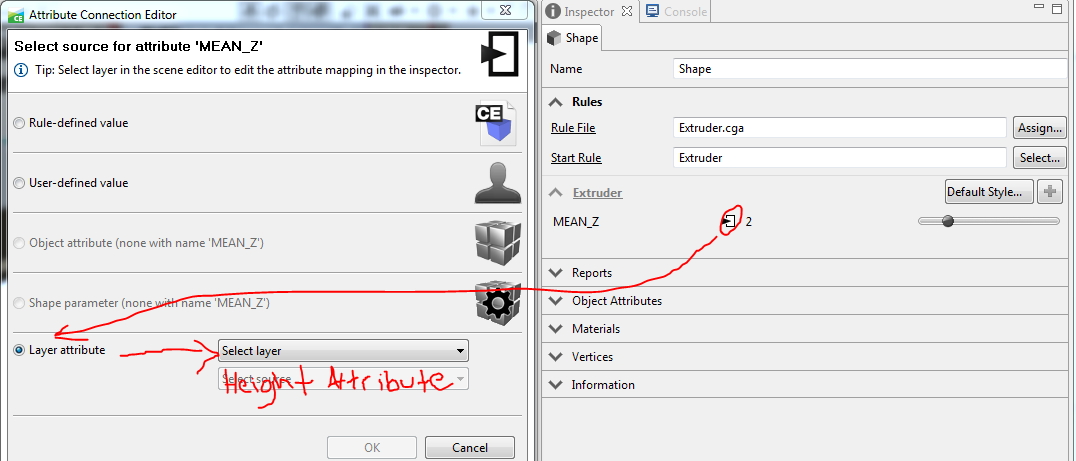
Click this symbol in your inspector window and connect the "MEAN_Z" CGA attribute to your shapefile "MEAN_Z" attr. Hope this helps.
- Mark as New
- Bookmark
- Subscribe
- Mute
- Subscribe to RSS Feed
- Permalink
Thank you so much Micah, Your answer helped me a lot! I have tried the answers you provided (the CGA code method and the layer attribute method) and both of them worked really well for my question. Both of them can change the height attribute value corresponding to the shapefile attribute.