- Home
- :
- All Communities
- :
- Products
- :
- ArcGIS CityEngine
- :
- ArcGIS CityEngine Questions
- :
- Re: elevation
- Subscribe to RSS Feed
- Mark Topic as New
- Mark Topic as Read
- Float this Topic for Current User
- Bookmark
- Subscribe
- Mute
- Printer Friendly Page
elevation
- Mark as New
- Bookmark
- Subscribe
- Mute
- Subscribe to RSS Feed
- Permalink
Hello,
I try to emphasize urban construction, to provide "elevation" with a layer "terrain" called "hightmap".
There is something that escapes me totalement.With older versions of CityEngine, I succeeded without problems.
With the 2016, I have to miss an obvious manipulation and I turn around ...
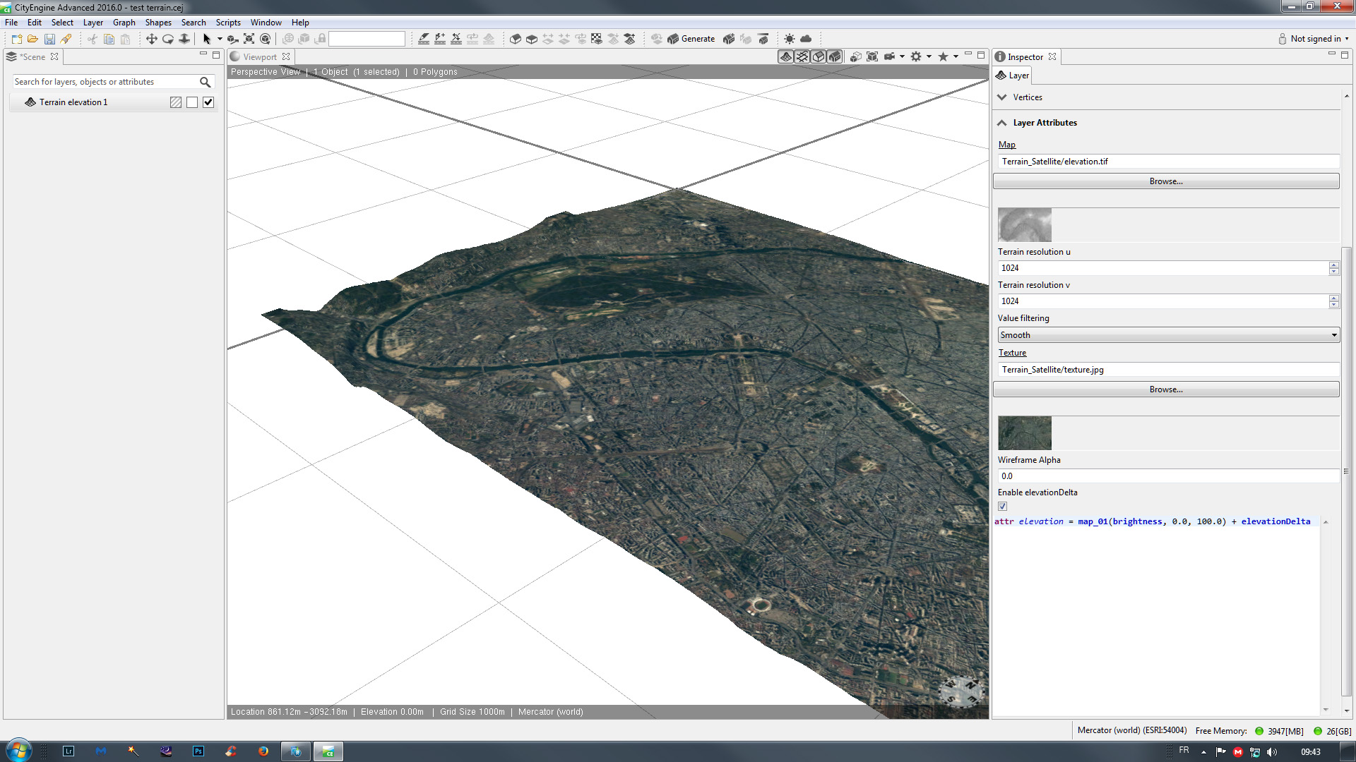
I can not find the line:
attr = elevation map_01 (brightness, 0.0, 150.0) ...
hightmap layer in the window "inspector" ...
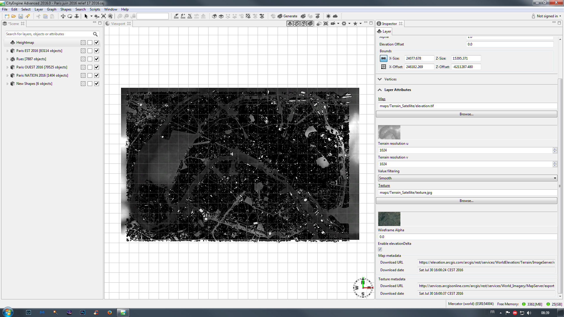
My image "elevation.tif" of "layer attributes" remains flat in the 3D view
I and I not manage to "align graph to terrain" ...
I know it must be simple. I looked ten times the tutorial videos and examples ...
I realized without problems in earlier versions of CityEngine ...
Can you help me find what I do not, I do not see ...
Thank you and good day
PS: the new version of your forum is much more confusing than the old.
It's very difficult to navigate ...
- Mark as New
- Bookmark
- Subscribe
- Mute
- Subscribe to RSS Feed
- Permalink
Hello Reit Sined,
Thank you for your report.
There have been no changes in that section of the Inspector. So you were looking in the right place.
For some reason the last part with the layer attributes is missing on your screenshot.
Please try to re-open the scene and check again.

- Mark as New
- Bookmark
- Subscribe
- Mute
- Subscribe to RSS Feed
- Permalink
Hello,
Thank you for your reply.
But no solution in sight.
I closed and re-opened the program
I turned off and on the computer
I repaired the program
I uninstalled and reinstalled the logitiel
Nothing better...
elevation remains flat and the line of code does not appear ...
Something had to "jump" ... but I do not know what
or a small cross in a mysterious little box ...
Finally, I'm pissed off ...
Have a good day
- Mark as New
- Bookmark
- Subscribe
- Mute
- Subscribe to RSS Feed
- Permalink
I even start a blank project much smaller in case ...
But the same ... The inspector does not release the code line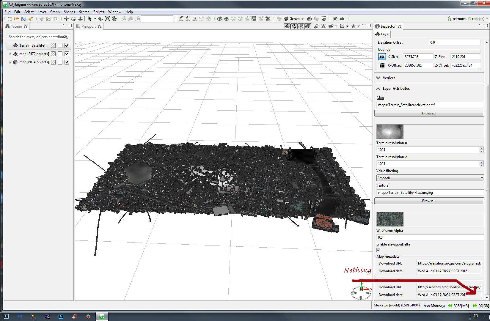 .
.
- Mark as New
- Bookmark
- Subscribe
- Mute
- Subscribe to RSS Feed
- Permalink
Thank you for you reply.
It looks like the Heightmap and Texture files have been successfully downloaded.
But clearly the terrain layers elevation attribute has has not been set.
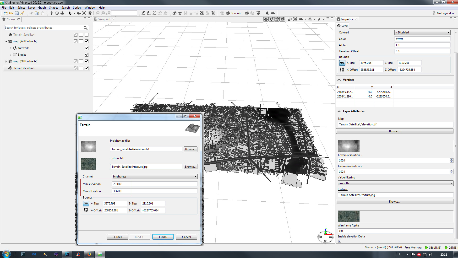
Could you please try to add the Heightmap manually by navigating to
maps/Terrain_Satellite4/elevation.tif
and right-click to import. As shown below, you can manually set the elevation attribute.

I hope this will provide a solution.
- Mark as New
- Bookmark
- Subscribe
- Mute
- Subscribe to RSS Feed
- Permalink
Thank you for your attention
So I followed your advice and manually entered values in the "terrain"
Nothing changes. No additional command line does not appear in the inspector and geometry remains flat.
On the other hand, I just noticed the absence of the "texture" on geometry
Only the "hightmap" black and white displays in the project.
Difficult, difficult ...
Best regards and good day
- Mark as New
- Bookmark
- Subscribe
- Mute
- Subscribe to RSS Feed
- Permalink
Hello,
An interim solution foresee.
I installed an old version of CityEngine 2011.
After creating a "terrain" elevation in this version (that works)
I imported this "scene" in CityEngine 2016
and there behold ... the famous line "attr = elevation ..." appears
and the relief is there in the 3D view ...
It is not simple but it works.
(I do not like the workflow system! And the principle of always open the last scene. It complicates things)
I think there must be simpler to handle.
Thank you for your attention and good weekend.
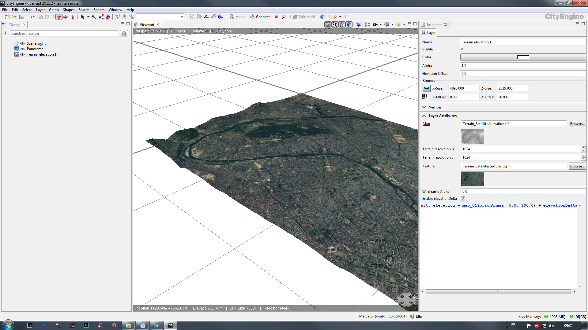
one picture of 2011 and another of 2016...
- Mark as New
- Bookmark
- Subscribe
- Mute
- Subscribe to RSS Feed
- Permalink
In the end everything seems back to normal ...
with the creation of a new "workspace" ... coming at one time or another that of CityEngine 2011 ...
I made so many manipulations between the two versions as soon as I saw that there was a progress I do not remember exactly at what moment everything is back OK with the 2016 release.
But here it works ... even with the "Get Map data" which is great!
Thank you and good day