- Home
- :
- All Communities
- :
- Products
- :
- ArcGIS CityEngine
- :
- ArcGIS CityEngine Questions
- :
- Align river to terrain
- Subscribe to RSS Feed
- Mark Topic as New
- Mark Topic as Read
- Float this Topic for Current User
- Bookmark
- Subscribe
- Mute
- Printer Friendly Page
Align river to terrain
- Mark as New
- Bookmark
- Subscribe
- Mute
- Subscribe to RSS Feed
- Permalink
Hello,
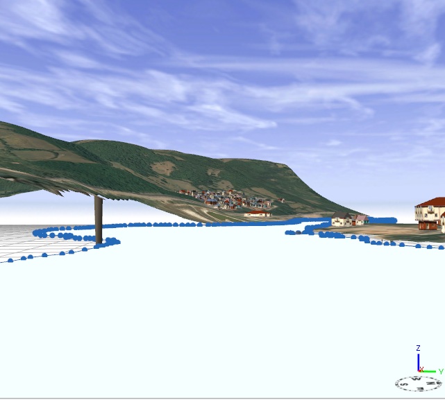
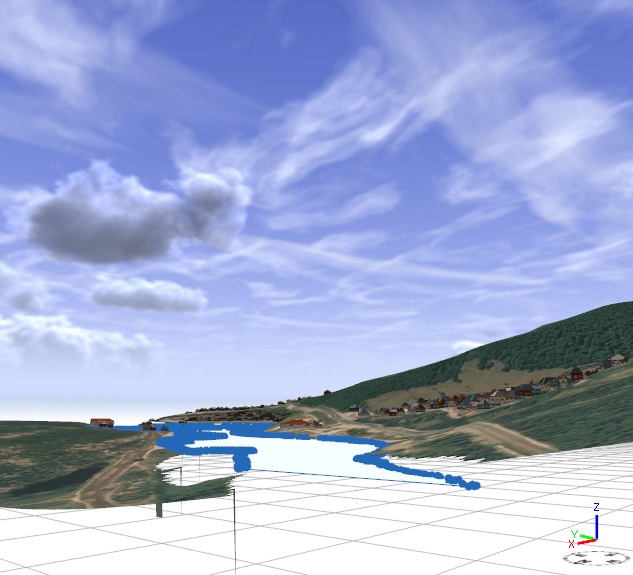
I have a problem regarding aligning a river to a terrain. For example: in west the terrain is lower than in the east and I`m having problem with the alignment of the river. Even if I use the optiune "Align shape to terrain", the river can not bend it`s polygonal form to the terrain elevation. I would like to use an option similar to "base heights" from ArcScene.
I have attached some prints.( The selected shape is the river and the terrain has a clipped ortophoto texture).
Any suggestions??
Thanks !!

- Mark as New
- Bookmark
- Subscribe
- Mute
- Subscribe to RSS Feed
- Permalink
Hey,
What options are you using in 'align shapes to terrain' ?
Did you use 'project' instead of 'translate' ? (Cos translate will not work ..)
Let me know.
Matt
Matthias Buehler
Head of 3D Technologies
twitter: @MattB3D
--------------------------------------
Garsdale Design Limited
- Mark as New
- Bookmark
- Subscribe
- Mute
- Subscribe to RSS Feed
- Permalink
To be honest I aligned it manually. What align function should I use ?
Thanks !
- Mark as New
- Bookmark
- Subscribe
- Mute
- Subscribe to RSS Feed
- Permalink
Well, the tool 'align shapes to terrain' has an options pulldown...
If you missed it, check the docs .. 😉
Ok ?
Matthias Buehler
Head of 3D Technologies
twitter: @MattB3D
--------------------------------------
Garsdale Design Limited
- Mark as New
- Bookmark
- Subscribe
- Mute
- Subscribe to RSS Feed
- Permalink
I saw, there are 6 of them and I tried them all but none of the option align my river correctly 
Thanks !
- Mark as New
- Bookmark
- Subscribe
- Mute
- Subscribe to RSS Feed
- Permalink
ok ..
what specific alignment do you need ?
can you create a schema ?
Matthias Buehler
Head of 3D Technologies
twitter: @MattB3D
---------------------------------
Garsdale Design Limited
[email protected]
- Mark as New
- Bookmark
- Subscribe
- Mute
- Subscribe to RSS Feed
- Permalink
I would like an alignment that would make my river same as terrain (elevation speaking- similar to float on DEM from ArcScene). To appear like the river floats on terrain and take it`s elevation.... I hope you understand me....
Check the pictures attached up to see, different elevation in different parts of terrain and I cannot make the river align the shape/elevation of terrain,,,
Thanks !