- Home
- :
- All Communities
- :
- Products
- :
- ArcGIS Business Analyst
- :
- ArcGIS Business Analyst Questions
- :
- Re: Why am I getting different numbers between BA ...
- Subscribe to RSS Feed
- Mark Topic as New
- Mark Topic as Read
- Float this Topic for Current User
- Bookmark
- Subscribe
- Mute
- Printer Friendly Page
Why am I getting different numbers between BA Desktop and BA Web?
- Mark as New
- Bookmark
- Subscribe
- Mute
- Subscribe to RSS Feed
- Permalink
Hello,
I've developed a custom infographic using 2019 Esri data and ACS 2013-2017 data. I am seeing discrepancies between Community Profile reports run in Pro and BA Web App. I also use that same data in my infographic and those numbers don't match what is in the Community Profile. Why is this happening? We provide both reports and infographics to our users and not having matching numbers brings the data into question.
I have attached a spreadsheet showing the discrepancies, as well as the Community Profile and Infographics I have run.
Thank you for your help,
Katie
- Mark as New
- Bookmark
- Subscribe
- Mute
- Subscribe to RSS Feed
- Permalink
Katherine,
I know your post here was back in October so not sure if you were able to resolve this but I would definitely recommend logging an Esri Support Case to investigate the issue/discrepancy (if you have did not already do so).
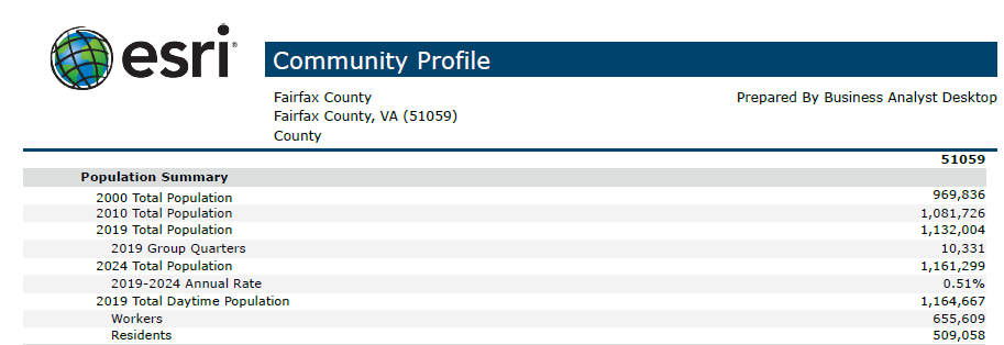
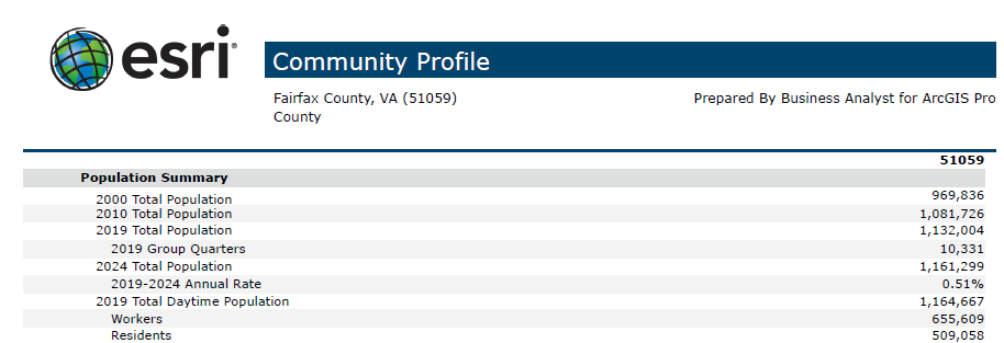
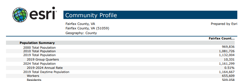
I did perform a quick check by running a Community Profile reports in Business Analyst Desktop/Pro/BAO. All the data values lined up. For the Business Analyst Desktop/Pro I created Fairfax County polygon feature with the local 2019/2024 dataset.


A couple last thoughts on what could be happening is the source of Fairfax County polygon you used on the Pro side (compared to the one BAO creates). Business Analyst Pro is also going to mirror the current data apportionment settings (from my current understanding but double checking) that are set in the Data tab in ArcGIS Business Analyst Desktop. This is default set to Hybrid (unmodified/stock) which will generally line up with BAO results though I realize non-custom polygons this does not impact this so a moot point (rings, drive times, hand drawn shapes, etc. will impact data values).
Regards,
Jason R..
- Mark as New
- Bookmark
- Subscribe
- Mute
- Subscribe to RSS Feed
- Permalink
Hi Jason,
Thanks for the reply. I was searching for where to change the apportionment settings in Pro. That makes sense if I have to do it in preferences of BA Desktop (ArcMap). I assume this will change in future releases?
Katie
- Mark as New
- Bookmark
- Subscribe
- Mute
- Subscribe to RSS Feed
- Permalink
Katherine,
I was not 100% sure if Enrich Layer in BA Pro was following along with BA Desktop preferences and started digging and it turns out I was incorrect there.
So for standard Esri variables there is no way to change the apportionment variables unless they create a Statistical Data Collection (basically the Pro version of Custom BDS layer from BA Desktop) where on can created a Statistical Data Collections of standard variables then change the apportionment method.
The online Help link is:
Create Business Analyst custom data—ArcGIS Pro | ArcGIS Desktop
Data apportionment
ArcGIS Pro employs a Weighted Centroid geographic retrieval methodology to aggregate data for rings and other polygons. The Weighted Centroid retrieval approach uses census block data to better apportion block groups that are not exclusively contained within a polygon. Here is a list of the apportionment methods you can apply to data fields:
This sounds like block apportionment instead of the default hybrid setting out of the box in Business Analyst Desktop but still double checking this.
For reference the below Help link that details the three apportionment methods available in Business Analyst Desktop:
Data tab—Help | ArcGIS Desktop
Regards,
Jason R.
- Mark as New
- Bookmark
- Subscribe
- Mute
- Subscribe to RSS Feed
- Permalink
Katherine,
I confirmed that custom Statistical Data Collection on the Pro side will be block apportionment. Just tracking down down how standard Esri variables are handled on the Pro side with Enrich Layer using local data. Online data naturally will use the same method as the Business Analyst web application (Business Analyst Online).
Calculation estimates for user-created areas—Business Analyst Web App | Documentation
Regards,
Jason R.
- Mark as New
- Bookmark
- Subscribe
- Mute
- Subscribe to RSS Feed
- Permalink
Ok it turns out my initial guess was correct. If Business Analyst Desktop is installed when using BA Pro tools on local data it will follow along with Business Analyst Desktop Preferences on the apportionment method selected on the Data tab.
If Business Analyst Desktop is not installed but client has install local Business Analyst dataset the default apportionment will by Hybrid.
Currently there is no ability in the UI on the Pro side to change this though creating a custom Statistical Data Collection with standard Esri variables one could change the apportionment.
Regards,
Jason R.
- Mark as New
- Bookmark
- Subscribe
- Mute
- Subscribe to RSS Feed
- Permalink
Thank you for following up with this. I have BA Desktop and it's set to Block Apportionment, which is how I want the data apportioned. I had logged a help call and the original thought was that the difference in numbers was a projection issue. I guess it is possible that the difference in values between BA Web App and BA Desktop/Pro is also the apportionment method.
Do you know if setting the apportionment method will be included in future releases of Pro? We work in small area so Block Apportionment will always be the best apportionment method for us so I want to make sure we will be able to set that.
Thanks!
Katie
- Mark as New
- Bookmark
- Subscribe
- Mute
- Subscribe to RSS Feed
- Permalink
Katherine,
As long as Business Analyst Desktop is installed and set to block apportionment Business Analyst Pro will use block apportionment.
I do believe it is a logical enhancement to have the ability to set apportionment in Business Analyst Pro especially for the scenario where one does not have Business Analyst Desktop installed but does have the local data installed and using Business Analyst Pro. I will go ahead and log one on the Esri Support side.
I did go through another round of testing focusing on running Community Profiles but this time not using local data. Also tested uploading a shapefile to BAO (Fairfax County) as well as a web map version and these reports all match each other (though 2019 population was 4 people difference compared to locally run Community Profile which is an acceptable difference) as well as testing online reports on the ArcGIS Pro side both feature class and web map layer.
Infographics on the ArcGIS Pro side with 2019 population also lines up with numbers in the above paragraph.
In your original post what was the source for the Fairfax County polygoon you were using?
Regards,
Jason R.