- Home
- :
- All Communities
- :
- Products
- :
- ArcGIS AppStudio
- :
- ArcGIS AppStudio Questions
- :
- Re: Quick Report template not able to use Multipoi...
- Subscribe to RSS Feed
- Mark Topic as New
- Mark Topic as Read
- Float this Topic for Current User
- Bookmark
- Subscribe
- Mute
- Printer Friendly Page
Quick Report template not able to use Multipoint Feature Service
- Mark as New
- Bookmark
- Subscribe
- Mute
- Subscribe to RSS Feed
- Permalink
We are using AppStudio for ArcGIS Desktop version 4.2.80
The AppStudio is configured with ArcGIS Portal 10.6
The features service is sync and editor tracking enabled, following is the JSON of the service:
{ "currentVersion": 10.6, "id": 0, "name": "GurDevOfflineSyncEditorTracking", "parentLayerId": -1, "defaultVisibility": true, "minScale": 0, "maxScale": 0, "type": "Feature Layer", "geometryType": "esriGeometryMultipoint", "description": "", "copyrightText": "", "editFieldsInfo": { "creationDateField": "created_date", "creatorField": "created_user", "editDateField": "last_edited_date", "editorField": "last_edited_user" }, "ownershipBasedAccessControlForFeatures": null, "syncCanReturnChanges": true, "relationships": [], "isDataVersioned": false, "supportsRollbackOnFailureParameter": true, "archivingInfo": { "supportsQueryWithHistoricMoment": true, "startArchivingMoment": 1584096599000 }, "supportsStatistics": true, "supportsAdvancedQueries": true, "supportsValidateSQL": true, "supportsCalculate": false, "advancedQueryCapabilities": { "supportsPagination": true, "supportsTrueCurve": true, "supportsQueryWithDistance": true, "supportsReturningQueryExtent": true, "supportsStatistics": true, "supportsOrderBy": true, "supportsDistinct": true, "supportsSqlExpression": true }, "extent": { "xmin": "NaN", "ymin": "NaN", "xmax": "NaN", "ymax": "NaN", "spatialReference": { "wkid": 102100, "latestWkid": 3857 } }, "drawingInfo": { "renderer": { "type": "simple", "symbol": { "type": "esriSMS", "style": "esriSMSCircle", "color": [ 51, 0, 133, 255 ], "size": 4, "angle": 0, "xoffset": 0, "yoffset": 0, "outline": { "color": [ 0, 0, 0, 255 ], "width": 1 } }, "label": "", "description": "" }, "transparency": 0, "labelingInfo": null }, "hasM": false, "hasZ": false, "allowGeometryUpdates": true, "allowTrueCurvesUpdates": false, "onlyAllowTrueCurveUpdatesByTrueCurveClients": false, "hasAttachments": false, "supportsApplyEditsWithGlobalIds": true, "htmlPopupType": "esriServerHTMLPopupTypeAsHTMLText", "objectIdField": "OBJECTID", "globalIdField": "GlobalID", "displayField": "Data", "typeIdField": "", "subtypeField": "", "fields": [ { "name": "Data", "type": "esriFieldTypeString", "alias": "Data", "domain": null, "editable": true, "nullable": true, "length": 50 }, { "name": "created_user", "type": "esriFieldTypeString", "alias": "created_user", "domain": null, "editable": false, "nullable": true, "length": 255 }, { "name": "created_date", "type": "esriFieldTypeDate", "alias": "created_date", "domain": null, "editable": false, "nullable": true, "length": 8 }, { "name": "last_edited_user", "type": "esriFieldTypeString", "alias": "last_edited_user", "domain": null, "editable": false, "nullable": true, "length": 255 }, { "name": "last_edited_date", "type": "esriFieldTypeDate", "alias": "last_edited_date", "domain": null, "editable": false, "nullable": true, "length": 8 }, { "name": "GlobalID", "type": "esriFieldTypeGlobalID", "alias": "GlobalID", "domain": null, "editable": false, "nullable": false, "length": 38 }, { "name": "OBJECTID", "type": "esriFieldTypeOID", "alias": "OBJECTID", "domain": null, "editable": false, "nullable": false } ], "indexes": [ { "name": "UUID_118", "fields": "GlobalID", "isAscending": true, "isUnique": true, "description": "" }, { "name": "gdb_ct3_118", "fields": "OBJECTID", "isAscending": true, "isUnique": false, "description": "" }, { "name": "S70_idx", "fields": "SHAPE", "isAscending": true, "isUnique": true, "description": "" } ], "dateFieldsTimeReference": { "timeZone": "UTC", "respectsDaylightSaving": false }, "types": [], "templates": [ { "name": "GurDevOfflineSyncEditorTracking", "description": "", "prototype": { "attributes": {"Data": null} }, "drawingTool": "esriFeatureEditToolPoint" } ], "maxRecordCount": 1000, "supportedQueryFormats": "JSON, AMF, geoJSON", "capabilities": "Create,Delete,Query,Sync,Update,Uploads,Editing", "useStandardizedQueries": true }When I run the Quick Report application with feature service defined above I get the following error:
Any suggestions will be appreciated.
- Mark as New
- Bookmark
- Subscribe
- Mute
- Subscribe to RSS Feed
- Permalink
Brent,
That is weird and based on the JSON you provided the feature layer support esriGeometryMultipoint.
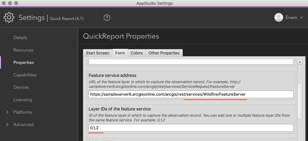
Just to make sure that you enter the feature layer field correctly in the setting, do you have the feature service and the layer name separated as shown below?
Thank you,
Erwin
- Mark as New
- Bookmark
- Subscribe
- Mute
- Subscribe to RSS Feed
- Permalink
Erwin, thank you for the quick response.
Yes we have made sure the parameters to the feature service and the layer ID are right:

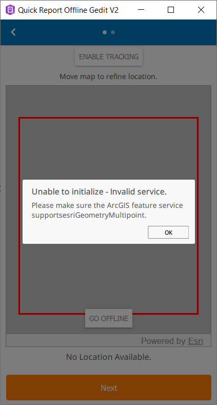
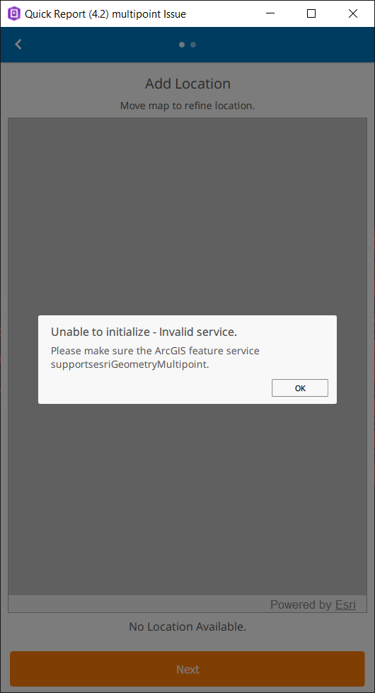
The app is able to read the service:

Its when I click on the multipoint layer I get the error.
- Mark as New
- Bookmark
- Subscribe
- Mute
- Subscribe to RSS Feed
- Permalink
I see, is there any way for you to share the feature layers to us privately? so that we can troubleshoot further. Please email it to [email protected]
- Mark as New
- Bookmark
- Subscribe
- Mute
- Subscribe to RSS Feed
- Permalink
Unfortunately, we would not be able to share the service with you.
However, I can give you the details of the feature class that can be published on your ArcGIS Server for testing.
Feature class geometry type: Multipoint
Assigned Global ID: true
Enabled Editor tracking: true
Enable Archiving: true
Database: Microsoft SQL
Please let me know if there is any other information required from my side.
- Mark as New
- Bookmark
- Subscribe
- Mute
- Subscribe to RSS Feed
- Permalink
Brent,
From that information you provided, everything looks fine. Maybe it is better if you can work with Esri Technical Support regarding this issue, they can help you troubleshoot this issue.
Erwin.
- Mark as New
- Bookmark
- Subscribe
- Mute
- Subscribe to RSS Feed
- Permalink
Erwin,
Thank you for the response, as suggested we would go ahead with ESRI technical support.
Thank you for your time.