- Home
- :
- All Communities
- :
- Products
- :
- ArcGIS AppStudio
- :
- ArcGIS AppStudio Questions
- :
- Re: AppStudio Workshop Spring 2020 Questions
- Subscribe to RSS Feed
- Mark Topic as New
- Mark Topic as Read
- Float this Topic for Current User
- Bookmark
- Subscribe
- Mute
- Printer Friendly Page
AppStudio Workshop Spring 2020 Questions
- Mark as New
- Bookmark
- Subscribe
- Mute
- Subscribe to RSS Feed
- Permalink
Use this discussion thread to ask questions that you would like answered during the AppStudio Workshop 2020. Use the "Add a Reply" button below to ask your question and we will either answer the question in this thread of discuss it at our next workshop session.
- Mark as New
- Bookmark
- Subscribe
- Mute
- Subscribe to RSS Feed
- Permalink
Thank you Tina for your guidance.
The following code change in panelPage.qml was able to display the popup from webmap.
//featuresView.layerName = popupManager.objectName featuresView.layerName = popupManager.popup.title var popupwebfields = popupManager.popup.popupDefinition.fields var popupModel = popupManager.displayedFields if (popupModel.count) { var feature1 = mapView.identifyProperties.features[currentPageNumber-1] var attributeJson1 = feature1.attributes.attributesJson attrListModel.clear() for(var key in attributeJson1) { // if(attributeJson1.hasOwnProperty(key)) // { // attrListModel.append({ // "label": key, // "fieldValue": attributeJson1[key]!== null?attributeJson1[key].toString():null // }) // } for(var cnt = 0; cnt < popupwebfields.length; cnt++){ var key1 = popupwebfields[cnt] if(key1.visible === true && key1.fieldName === key){ attrListModel.append({ "label": key1.label, "fieldValue": attributeJson1[key]!== null?attributeJson1[key].toString():null }) break } } } return attrListModel //return popupManager.displayedFields
- Mark as New
- Bookmark
- Subscribe
- Mute
- Subscribe to RSS Feed
- Permalink
Dear Mallemala Kishore
I would also really like the webmap popups to be honoured in my MapViewer app. You seem to have modified the code to get it to work.
Can you please provide a bit more details as to where in the PanelPage.qml you made these changes?
Did you also need to make changes to the IdentifyFeaturesView.qml?
Thank you
- Mark as New
- Bookmark
- Subscribe
- Mute
- Subscribe to RSS Feed
- Permalink
Hi Mervyn,
You have to change only in PanelPage.qml. navigate to:
Component {
id: identifyFeaturesViewsection and replace the function
function bindModel () {with following code:
function bindModel () {
featuresView.model = Qt.binding(function () {
try {
//Custome Code
console.log("attributes",
JSON.stringify(mapView.identifyProperties.features[currentPageNumber-1].geometry.json));
var spatialReference = ArcGISRuntimeEnvironment.createObject("SpatialReference", {wkid: 4326});
var projectedPoint = GeometryEngine.project(mapView.identifyProperties.features[currentPageNumber-1].geometry, spatialReference);
console.log("projectedPoint", JSON.stringify(projectedPoint.json));
featuresView.directionLat = projectedPoint.y;
featuresView.directionLong = projectedPoint.x;
// Custome Code Ends
var popupManager = mapView.identifyProperties.popupManagers[currentPageNumber-1]
//featuresView.layerName = popupManager.objectName
featuresView.layerName = popupManager.popup.title
var popupwebfields = popupManager.popup.popupDefinition.fields
var popupModel = popupManager.displayedFields
if (popupModel.count) {
var feature1 = mapView.identifyProperties.features[currentPageNumber-1]
var attributeJson1 = feature1.attributes.attributesJson
attrListModel.clear()
for(var key in attributeJson1)
{
// if(attributeJson1.hasOwnProperty(key))
// {
// attrListModel.append({
// "label": key,
// "fieldValue": attributeJson1[key]!== null?attributeJson1[key].toString():null
// })
// }
for(var cnt = 0; cnt < popupwebfields.length; cnt++){
var key1 = popupwebfields[cnt]
if(key1.visible === true && key1.fieldName === key){
attrListModel.append({
"label": key1.label,
"fieldValue": attributeJson1[key]!== null?attributeJson1[key].toString():null
})
break
}
}
}
return attrListModel
//return popupManager.displayedFields
} else {
// This case handles map notes
var feature = mapView.identifyProperties.features[currentPageNumber-1]
var attributeJson = feature.attributes.attributesJson
attrListModel.clear()
if (attributeJson.hasOwnProperty("TITLE")) {
if (attributeJson["TITLE"]) {
attrListModel.append({
"label": "TITLE", //qsTr("Title"),
"fieldValue": attributeJson["TITLE"].toString()
})
}
}
if (attributeJson.hasOwnProperty("DESCRIPTION")) {
if (attributeJson["DESCRIPTION"]) {
attrListModel.append({
"label": "DESCRIPTION", //qsTr("Description"),
"fieldValue": attributeJson["DESCRIPTION"].toString()
})
}
}
if (attributeJson.hasOwnProperty("IMAGE_LINK_URL")) {
if (attributeJson["IMAGE_LINK_URL"]) {
attrListModel.append({
"label": "IMAGE_LINK_URL",
"fieldValue": attributeJson["IMAGE_LINK_URL"].toString()
})
}
}
return attrListModel
}
} catch (err) {
featuresView.layerName = ""
return defaultListModel
}
})
}This is working fine for my requirements. you can fine tune the code as required.
- Mark as New
- Bookmark
- Subscribe
- Mute
- Subscribe to RSS Feed
- Permalink
Thank you so much! I really appreciate the assistance.
- Mark as New
- Bookmark
- Subscribe
- Mute
- Subscribe to RSS Feed
- Permalink
Hi Course Organizers
Please can you explain the usage of scaleFactor in the Style documentation. Applying the rules distort my widgets. I am not following the rules correctly.
AppStudio sample style guide · Esri/developer-support Wiki · GitHub
- Properties that take a pixel value should be multiplied by display scale factor to adjust for different DPI devices. The exception to this rule appears to be with our API- it seems that Runtime Core already scales the size of things like Simple Marker Symbols for you, so this step is not needed. A property can be declared at the top of the qml file to use throughout the sample. Be sure to have imported ArcGIS.AppFramework 1.0:
import ArcGIS.AppFramework 1.0 property double scaleFactor: AppFramework.displayScaleFactor- Items anchored on the side, top, or bottom should have margins set to 10 * scaleFactor
- If you need a panel of 'controls', preferred anchoring is top left corner. Use a column for the controls, and anchor a background grey box to it. In order to maintain the anchoring of 10, you need ot set the anchoring of the column to 20 and then the margin of the background to -10. eg:
Regards
John
- Mark as New
- Bookmark
- Subscribe
- Mute
- Subscribe to RSS Feed
- Permalink
John,
I think this will help you understand the concept of displayScaleFactor in QML, https://community.esri.com/thread/197716-how-to-use-the-displayscalefactor
Thank you,
Erwin
- Mark as New
- Bookmark
- Subscribe
- Mute
- Subscribe to RSS Feed
- Permalink
Dear ApddStudio Team
After configuring some of my webmaps to show in the MapViewer template, I created the executables for Android and Windows 10 desktop. I then installed them on the respective devices.
I have two questions.
1) When the MapViewer loads in Windows, there does not seem to be a menu option to close the application. Am I missing something? On Android it is easy to just click on teh back button to exit the application.
2) Is it possible to load a static image, like a logo, to the webmap header page? If so, would it be on the Panel.qml or MenuPage.qml control pages? Could you please provide a bit more detail if it is possible?
Thank you
- Mark as New
- Bookmark
- Subscribe
- Mute
- Subscribe to RSS Feed
- Permalink
Just to add to with my first question above regarding the difficulty of closing the MapViewer app on a Windows device, it seems to be intermittent. I am running the app on a computer with dual monitors and sometimes the app opens fullscreen without the thin white strip at the top, which does have the option to close the app, other times this strip/header is not present so it it more difficult to close using conventional ways.
I will see if I can reproduce it more reliably.
- Mark as New
- Bookmark
- Subscribe
- Mute
- Subscribe to RSS Feed
- Permalink
I was also able to add a logo to the header Toolbar and ColumnLayout on the GalleryPage and MapPage. They just appear a bit small.
This was the code I used. Any suggestions as to a better way of doing so or how to increase image size?
Thanks.
ColumnLayout {
id: toolBarColumn
width: parent.width
spacing: 0
Item {
Layout.fillWidth: true
Layout.preferredHeight: headerRow.height
RowLayout {
id: headerRow
height: app.headerHeight
spacing: 0
Controls.Icon {
imageSource: "../images/mtpa2.png"
Layout.leftMargin: app.widthOffset
Layout.alignment: Qt.AlignVCenter
}
- Mark as New
- Bookmark
- Subscribe
- Mute
- Subscribe to RSS Feed
- Permalink
Hi,
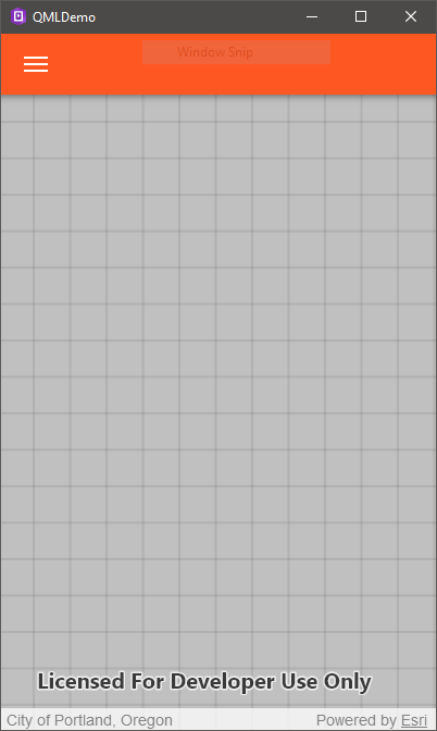
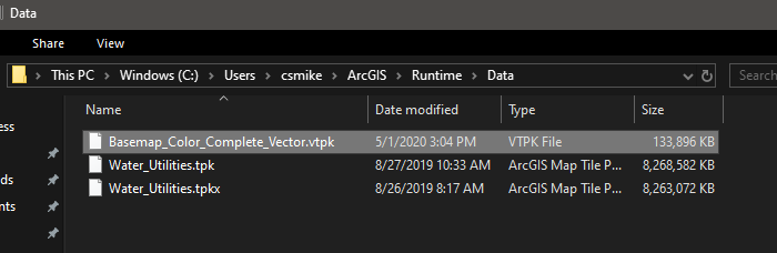
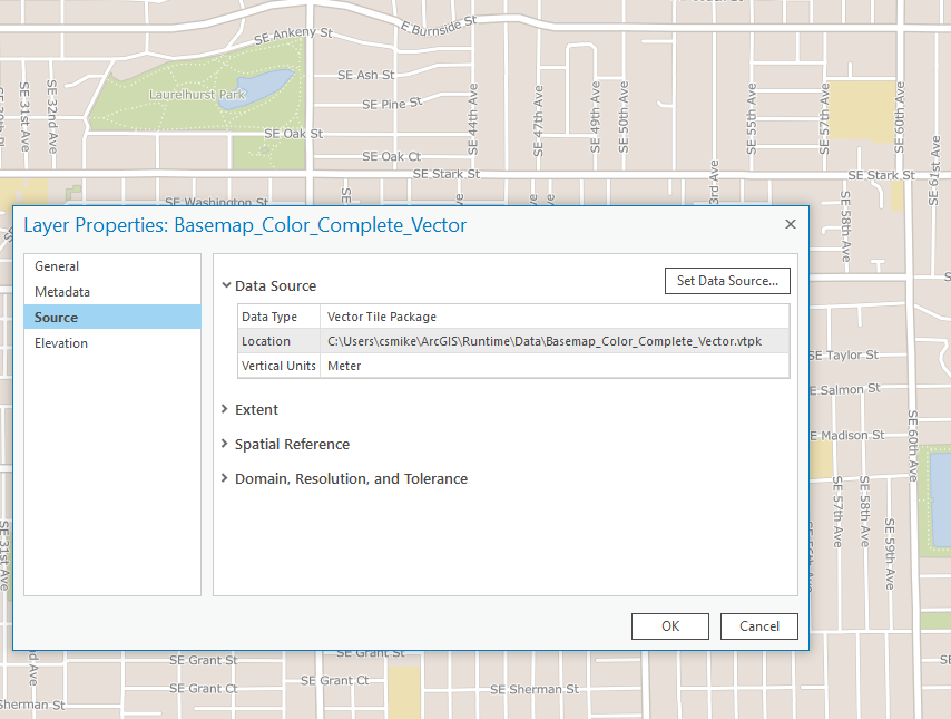
I've got a vector tile package that I'm trying to load into a MapView. The map control is definitely added to the page (building off Tuesday's lab), but I can't get the .vtpk to draw. Seems like something silly that I'm missing. I'm sure the vector tile package is valid (draws fine in pro, I've published it as a hosted service) and the initial viewpoint should be just within the data area. Appreciate any pointers.
Here is the code snipped I'm working with:
MapView {
id: mapView
anchors.fill: parent
Map {
id: map
Basemap {
ArcGISVectorTiledLayer {
id: vectorbasemap
url: AppFramework.userHomePath + "/ArcGIS/Runtime/Data/Basemap_Color_Complete_Vector.vtpk"
}
}
initialViewpoint: ViewpointCenter {
id: initialViewpoint
center: Point {
x: 13647642.0
y: 5703059.0
spatialReference: SpatialReference {wkid: 3857}
}
targetScale: 72224.0
}
}
}which results in this:
The data location should be fine, I think:
This is what the same tile package looks like in pro:
Thanks for the workshop, it's been great and helping to give me the push I needed. AppStudio, AppStudio Player and Qt/QML are (for some reason) more attractive to me than Xamarin... and that's coming from a .NET developer. 