- Home
- :
- All Communities
- :
- Products
- :
- ArcGIS AppStudio
- :
- ArcGIS AppStudio Questions
- :
- Re: AppStudio Workshop Spring 2020 Questions
- Subscribe to RSS Feed
- Mark Topic as New
- Mark Topic as Read
- Float this Topic for Current User
- Bookmark
- Subscribe
- Mute
- Printer Friendly Page
AppStudio Workshop Spring 2020 Questions
- Mark as New
- Bookmark
- Subscribe
- Mute
- Subscribe to RSS Feed
- Permalink
Use this discussion thread to ask questions that you would like answered during the AppStudio Workshop 2020. Use the "Add a Reply" button below to ask your question and we will either answer the question in this thread of discuss it at our next workshop session.
- Mark as New
- Bookmark
- Subscribe
- Mute
- Subscribe to RSS Feed
- Permalink
Thanks for a great first day of class! I have what I hope is a quick question, perhaps it will be covered later. Here https://developers.arcgis.com/qt/latest/qml/guide/geoprocessing.htm I see this: “As an ArcGIS Desktop user, you can share a geoprocessing package or publish a web service to enable an ArcGIS Runtime SDK app to consume a geoprocessing task.”
…but can we use ArcGIS Pro instead to publish a geoprocessing web service that can be consumed as a geoprocessing task…? I assume it is yes…. https://pro.arcgis.com/en/pro-app/help/analysis/geoprocessing/share-analysis/what-is-a-geoprocessing... ... it would not make much sense for AppStudio to still reply only on Desktop given Esri’s desire to move all things to Pro, right?
Thanks so much! Jen
- Mark as New
- Bookmark
- Subscribe
- Mute
- Subscribe to RSS Feed
- Permalink
Hi Jen,
Thanks for attending the workshop. We hope to see you again.
Yes, ArcGIS Pro can be used to publish the GP service. ArcGIS Pro aka ArcGIS Desktop can be use to create, publish and consume a GP service and it works only on windows. However, once published the service can be consumed in the AppStudio+ ArcGIS Runtime app which can run on multiple platforms (iOS, Android, Windows, MacOS, Linux). Again AppStudio cannot be used to create a GP service. Only can be used to consume it in a client native application. We have a sample app available on how to consume a GP service created from a ArcGIS Pro in a AppStudio application using ArcGIS Runtime.
Please let me know if this helps.
Thanks,
Nakul
- Mark as New
- Bookmark
- Subscribe
- Mute
- Subscribe to RSS Feed
- Permalink
Hi Nakul,
Perfect, thanks so much for this info and fast reply. But can you please check the URL to the "sample app"?
Thank you! Jen
- Mark as New
- Bookmark
- Subscribe
- Mute
- Subscribe to RSS Feed
- Permalink
Are you able to access this https://github.com/Esri/arcgis-appstudio-samples ? And then look for the Analyze ViewShed sample.
Nakul
- Mark as New
- Bookmark
- Subscribe
- Mute
- Subscribe to RSS Feed
- Permalink
Thank you for the great workshop! I have two questions may be simple but I don't know how to fix it. questions are:
1. Using the Mapviewer template, when we have multiple layers of data and when I launch the app in a device it shows all the layers initially but I want it to show only one layer when the app is opened. is there any way for this in the template?
2. I have used a web map in the Map viewer template. when my mobile device is offline the map is not shown, so is there any settings for this to show my map offline too.
Thank you so much,
Karimullah Sefat
- Mark as New
- Bookmark
- Subscribe
- Mute
- Subscribe to RSS Feed
- Permalink
Hi Karimullah,
I am glad you enjoyed the workshop!
Let me answer your question 2 first
2- WebMaps only work in the online mode. If you are interested in loading offline maps. You have two options.
First one is configure and consume Mobile Map packages (MMPK). You can learn more about it here
Second option is to prepare your WebMaps ready with preplanned workflow. Please check out the section -support for the offline map areas
1. Are you referring to different web maps cards (as shown in the image below) ? or the layers within a single web map? 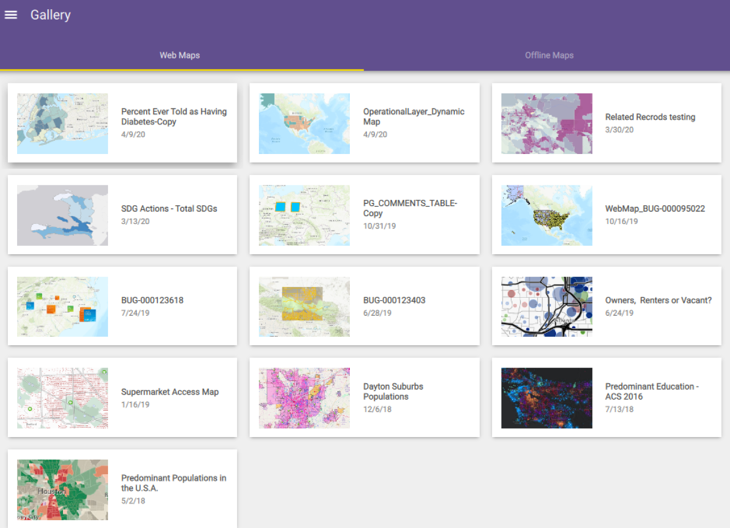
Thanks,
Nakul
- Mark as New
- Bookmark
- Subscribe
- Mute
- Subscribe to RSS Feed
- Permalink
Hi Nakul,
Thank you for the answers,
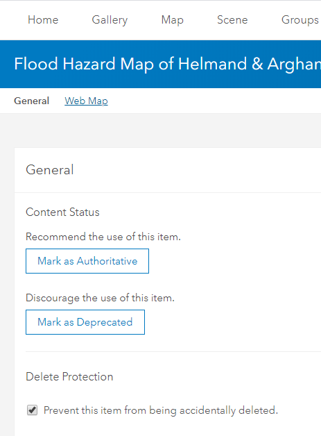
In question #2, I have tried the second option mentioned in your answer, but I cannot get the offline option in the settings of my web map (figure below). Just for clarity, I created my web map by directly adding the layers in Map Viewer and then launched it, I am not sure if there is an error in my web map.
regarding question #1, I mean the layers within a single web map. I have flood hazard area layers for different return periods and I want that it shows me one layer initially and based on the need the rest of layers will be enabled by users.
Thank you,
Sefat
- Mark as New
- Bookmark
- Subscribe
- Mute
- Subscribe to RSS Feed
- Permalink
Question 2- Did you look into this link which in the blog I linked above? Without that you cannot get offline areas in AppStudio Map Viewer template. If you more questions on that please post your question with the ArcGIS Online.
Question 1- Yes you set the visibility of layers dynamically as soon as the web map loads in the template application. But that requires you to write some code. The templates allows users/authors to customize it as per their needs. Currently, in Map Viewer there is layer list and you can turn on or off layer visibility manually though. If you are interested I can look for a sample or code snippet how to dynamically turn off layers.
Thank you.
Nakul
- Mark as New
- Bookmark
- Subscribe
- Mute
- Subscribe to RSS Feed
- Permalink
Thank you so much for your great answers,
That will help much more if I can get a sample or the code snippet for turning of layers visibility.
Thank you.
Sefat