Turn on suggestions
Auto-suggest helps you quickly narrow down your search results by suggesting possible matches as you type.
Cancel
- Home
- :
- All Communities
- :
- Developers
- :
- ArcGIS API Silverlight (Retired)
- :
- ArcGIS API Silverlight Questions
- :
- Some MapService Layers Query results won't display...
Options
- Subscribe to RSS Feed
- Mark Topic as New
- Mark Topic as Read
- Float this Topic for Current User
- Bookmark
- Subscribe
- Mute
- Printer Friendly Page
Some MapService Layers Query results won't display as graphics layers
Subscribe
03-28-2012
04:15 AM
- Mark as New
- Bookmark
- Subscribe
- Mute
- Subscribe to RSS Feed
- Permalink
I'm using the find example and when i query my storm map service everything works. WHen i query my water map services i get results in the datagrid but they won't show up as graphics layers when i select them.
Here is the returned Json for Storm (WORKING)
Here is the returned Json for Water (NOT WORKING)
Here is a storm layer attribute
Here is a water layer attributes, I think something is messed up here
What do you think is the problem here?
Here is the returned Json for Storm (WORKING)
{ "results" : [ { "layerId" : 0, "layerName" : "GIS.GISADMIN.StormNodes", "displayFieldName" : "NodeType", "foundFieldName" : "OBJECTID", "value" : "11", "attributes" : { "OBJECTID" : "11", "Element_ID" : "0", "SOURCE_DES" : "Sanitary Sewer Improvements Contract 10-S", "Coordinate" : "648444.115, 2060333.176", "Shape" : "Point" }, "geometryType" : "esriGeometryPoint", "geometry" : { "x" : -9146569.69071188, "y" : 5078354.76733345, "spatialReference" : { "wkid" : 102100 } } }, { "layerId" : 2, "layerName" : "GIS.GISADMIN.OutFalls", "displayFieldName" : "StreamName", "foundFieldName" : "OBJECTID", "value" : "11", "attributes" : { "OBJECTID" : "11", "StreamName" : "Black River", "OutFallName" : "Tacoma", "Shape" : "Point", "Type" : "Outfall", "Name" : "Null", "Notes" : "Null", "Notes_1" : "Null", "Oberservation_Date" : "Null", "Oberserver" : "Null" }, "geometryType" : "esriGeometryPoint", "geometry" : { "x" : -9140394.26845358, "y" : 5078269.86245744, "spatialReference" : { "wkid" : 102100 } } } ] }Here is the returned Json for Water (NOT WORKING)
{ "results" : [ { "layerId" : 0, "layerName" : "Hydrants", "displayFieldName" : "HYDRANTNUMBER", "foundFieldName" : "OBJECTID", "value" : "11", "attributes" : { "OBJECTID" : "11", "HydrantNumber" : "H0561", "Location" : "S.W. CORNER OF BROWNELL AVE.AND WEST ERIE AVE", "Hyd_Num" : "Null" }, "geometryType" : "esriGeometryPoint", "geometry" : { "x" : -9149034.62292915, "y" : 5081286.44737778, "spatialReference" : { "wkid" : 102100 } } }, { "layerId" : 1, "layerName" : "Valves", "displayFieldName" : "VALVENUMBER", "foundFieldName" : "OBJECTID", "value" : "11", "attributes" : { "OBJECTID" : "11", "ValveNumber" : "V4016", "Valve_Diameter" : "8" }, "geometryType" : "esriGeometryPoint", "geometry" : { "x" : -9153324.01843533, "y" : 5077188.05044879, "spatialReference" : { "wkid" : 102100 } } }, { "layerId" : 2, "layerName" : "LateralNodes", "displayFieldName" : "ENABLED", "foundFieldName" : "OBJECTID", "value" : "11", "attributes" : { "OBJECTID" : "11", "Enabled" : "True", "SHAPE" : "Point" }, "geometryType" : "esriGeometryPoint", "geometry" : { "x" : -9159684.58115913, "y" : 5072989.92068145, "spatialReference" : { "wkid" : 102100 } } } ] }Here is a storm layer attribute
Layer: GIS.GISADMIN.StormNodes (ID: 0) Display Field: NodeType Type: Feature Layer Geometry Type: esriGeometryPoint Description: Definition Expression: Copyright Text: Min. Scale: 10000 Max. Scale: 0 Default Visibility: True Extent: XMin: 2051575.44395877 YMin: 644699.275933608 XMax: 2071690.73607719 YMax: 657055.237114027 Spatial Reference: 3734 Has Attachments: False HTML Popup Type: esriServerHTMLPopupTypeAsHTMLText Drawing Info: Renderer: Unique Value Renderer: Field 1: NodeType Field 2: Field 3: Field Delimiter: , Default Symbol: Unsupported Symbol Default Label: Unique Value Infos: Value: Gutter Inlet Label: Gutter Inlet Description: Symbol: Picture Marker Symbol: Value: Inlet Basin Label: Inlet Basin Description: Symbol: Picture Marker Symbol: Value: Manhole Label: Manhole Description: Symbol: Picture Marker Symbol: Transparency: 0 Labeling Info: N/A Fields: OBJECTID (Type: esriFieldTypeOID, Alias: OBJECTID) Element_ID (Type: esriFieldTypeDouble, Alias: Element_ID) NodeType (Type: esriFieldTypeString, Alias: NodeType, Length: 32 ) NodeNumber (Type: esriFieldTypeString, Alias: NodeNumber, Length: 32 ) Coordinate (Type: esriFieldTypeString, Alias: Coordinate, Length: 30 ) Shape (Type: esriFieldTypeGeometry, Alias: Shape) Type ID Field: N/A Supported Interfaces: REST Supported Operations: Query
Here is a water layer attributes, I think something is messed up here
Layer: Hydrants (ID: 0) Display Field: HYDRANTNUMBER Type: Feature Layer Geometry Type: esriGeometryPoint Description: Definition Expression: Copyright Text: Min. Scale: 10000 Max. Scale: 0 Default Visibility: True Extent: XMin: 2028056.97998909 YMin: 628506.51000617 XMax: 2077442.1400012 YMax: 662339.880002109 Spatial Reference: 3734 Has Attachments: False HTML Popup Type: esriServerHTMLPopupTypeNone Drawing Info: Renderer: Unique Value Renderer: Field 1: Enabled Field 2: Field 3: Field Delimiter: , Default Symbol: Unsupported Symbol Default Label: Unique Value Infos: Value: 0 Label: False Description: Symbol: Picture Marker Symbol: Value: 1 Label: True Description: Symbol: Picture Marker Symbol: Transparency: 0 Labeling Info: Label Placement: esriServerPointLabelPlacementBelowCenter Label Expression: [HYDRANTNUMBER] Use Coded Values: True Symbol: Simple Text Symbol: Type: esriTS Color:255, 0, 0, 255 Background Color: null Border Line Color: null Vertical Alignment: bottom Horizontal Alignment: center Right To Left: False Angle: 0 XOffset: 0 YOffset: 0 Font Family: Arial Font Size: 8 Font Style: normal Font Weight: bold Font Decoration: none Min. Scale: 0 Max. Scale: 0 Fields: OBJECTID (Type: esriFieldTypeOID, Alias: OBJECTID) HydrantNumber (Type: esriFieldTypeString, Alias: HydrantNumber, Length: 16 ) YearInstalled (Type: esriFieldTypeInteger, Alias: YearInstalled) Manufacturer (Type: esriFieldTypeString, Alias: Manufacturer, Length: 32 ) Hyd_Num (Type: esriFieldTypeInteger, Alias: Hyd_Num) Type ID Field: N/A Supported Interfaces: REST Supported Operations: Query
What do you think is the problem here?
Solved! Go to Solution.
1 Solution
Accepted Solutions
03-30-2012
04:47 PM
- Mark as New
- Bookmark
- Subscribe
- Mute
- Subscribe to RSS Feed
- Permalink
I think I found out the issue.
It's because your shape field is called SHAPE (uppercase) and the Find sample is looking for an attribute called "Shape".
If you replace "SHAPE" by "Shape" that will work for your second service (but no more for the first one).
The test can be more generic:
should work in both cases.
It's because your shape field is called SHAPE (uppercase) and the Find sample is looking for an attribute called "Shape".
switch (graphic.Attributes["Shape"].ToString()) .....
If you replace "SHAPE" by "Shape" that will work for your second service (but no more for the first one).
The test can be more generic:
if (graphic.Geometry is Polygon) graphic.Symbol = LayoutRoot.Resources["DefaultFillSymbol"] as ESRI.ArcGIS.Client.Symbols.Symbol; else if (graphic.Geometry is Polyline) graphic.Symbol = LayoutRoot.Resources["DefaultLineSymbol"] as ESRI.ArcGIS.Client.Symbols.Symbol; else if (graphic.Geometry is MapPoint) graphic.Symbol = LayoutRoot.Resources["DefaultMarkerSymbol"] as ESRI.ArcGIS.Client.Symbols.Symbol;
should work in both cases.
15 Replies
03-29-2012
12:21 AM
- Mark as New
- Bookmark
- Subscribe
- Mute
- Subscribe to RSS Feed
- Permalink
In your non working case, it looks like the field used for the rendering (i.e. 'Enabled') is not published by the service.
Check that your service is not hiding that field.
If you have no access to the service, the client workaround might to define your own renderer at the client side, for example a SimpleRenderer using the same symbol for all features.
Check that your service is not hiding that field.
If you have no access to the service, the client workaround might to define your own renderer at the client side, for example a SimpleRenderer using the same symbol for all features.
03-29-2012
04:22 AM
- Mark as New
- Bookmark
- Subscribe
- Mute
- Subscribe to RSS Feed
- Permalink
In your non working case, it looks like the field used for the rendering (i.e. 'Enabled') is not published by the service.
Check that your service is not hiding that field.
I'm pretty sure the service isn't hiding it, whenever I add it as a ArcGISDynamicMapServiceLayer it shows up just fine with all the published symbology.
03-29-2012
04:59 AM
- Mark as New
- Bookmark
- Subscribe
- Mute
- Subscribe to RSS Feed
- Permalink
Fields:
OBJECTID (Type: esriFieldTypeOID, Alias: OBJECTID)
HydrantNumber (Type: esriFieldTypeString, Alias: HydrantNumber, Length: 16 )
YearInstalled (Type: esriFieldTypeInteger, Alias: YearInstalled)
Manufacturer (Type: esriFieldTypeString, Alias: Manufacturer, Length: 32 )
Hyd_Num (Type: esriFieldTypeInteger, Alias: Hyd_Num)
Type ID Field: N/A
'Enabled' doesn't seem to be in the list of published fields.
ArcGISDynamicMapServiceLayer shows up fine because the rendering is done at the server side and doesn't need any published fields.
03-29-2012
05:34 AM
- Mark as New
- Bookmark
- Subscribe
- Mute
- Subscribe to RSS Feed
- Permalink
Sorry to be miss leading, but the post only allowed for 1000 characters in this forum so i had to remove some things. Here is what the hydrants page looks like.
This used to work with the water features before I made the symbols based on enabled. Therefore I thought that does have something to do with it. Then I did published the features again without any custom symbology and it didn't work still, so I'm just lost now.
Layer: Hydrants (ID: 0)
Display Field: HYDRANTNUMBER

Type: Feature Layer

Geometry Type: esriGeometryPoint

Description:

Definition Expression:

Copyright Text:

Min. Scale: 10000

Max. Scale: 0

Default Visibility: True

Extent:

    XMin: 2028056.97998909
    YMin: 628506.51000617
    XMax: 2077442.1400012
    YMax: 662339.880002109
    Spatial Reference: 3734

Has Attachments: False

HTML Popup Type: esriServerHTMLPopupTypeNone

Drawing Info:

    Renderer:
        Unique Value Renderer:

        Field 1: Enabled
        Field 2:
        Field 3:
        Field Delimiter: ,
        Default Symbol:
            Unsupported Symbol
        Default Label:
        Unique Value Infos:
            Value: 0
            Label: False
            Description:
            Symbol:
                Picture Marker Symbol:

            Value: 1
            Label: True
            Description:
            Symbol:
                Picture Marker Symbol:

    Transparency: 0
    Labeling Info:
        Label Placement: esriServerPointLabelPlacementBelowCenter
        Label Expression: [HYDRANTNUMBER]
        Use Coded Values: True
        Symbol:
            Simple Text Symbol:
            Type: esriTS
            Color:255, 0, 0, 255
            Background Color: null
            Border Line Color: null
            Vertical Alignment: bottom
            Horizontal Alignment: center
            Right To Left: False
            Angle: 0
            XOffset: 0
            YOffset: 0
            Font Family: Arial
            Font Size: 8
            Font Style: normal
            Font Weight: bold
            Font Decoration: none
        Min. Scale: 0
        Max. Scale: 0

Fields:

    OBJECTID (Type: esriFieldTypeOID, Alias: OBJECTID)
    HydrantNumber (Type: esriFieldTypeString, Alias: HydrantNumber, Length: 16 )
    YearInstalled (Type: esriFieldTypeInteger, Alias: YearInstalled)
    Manufacturer (Type: esriFieldTypeString, Alias: Manufacturer, Length: 32 )
    Model (Type: esriFieldTypeString, Alias: Model, Length: 32 )
    Ownership (Type: esriFieldTypeString, Alias: Ownership, Length: 32 )
    DrawingSet_ID (Type: esriFieldTypeInteger, Alias: DrawingSet_ID)
    DrawingSheet (Type: esriFieldTypeString, Alias: DrawingSheet, Length: 8 )
    SHAPE (Type: esriFieldTypeGeometry, Alias: SHAPE)
    Enabled (Type: esriFieldTypeSmallInteger, Alias: Enabled, Domain: Coded Values: [0: False], [1: True] )
    SOURCE_DESCRIPTION (Type: esriFieldTypeString, Alias: SOURCE_DESCRIPTION, Length: 64 )
    FOLDER (Type: esriFieldTypeString, Alias: FOLDER, Length: 128 )
    Location (Type: esriFieldTypeString, Alias: Location, Length: 255 )
    Hyd_Num (Type: esriFieldTypeInteger, Alias: Hyd_Num)

Type ID Field: N/A

Supported Interfaces:   REST

Supported Operations:   Query
This used to work with the water features before I made the symbols based on enabled. Therefore I thought that does have something to do with it. Then I did published the features again without any custom symbology and it didn't work still, so I'm just lost now.
03-29-2012
05:48 AM
- Mark as New
- Bookmark
- Subscribe
- Mute
- Subscribe to RSS Feed
- Permalink
Sorry to be miss leading, but the post only allowed for 1000 characters in this forum so i had to remove some things.
OK looks good.
Try to define a renderer at the client side to know if it's a rendering issue.
You could also look at the requests sent to the server with fiddler (or any HTTP sniffer), that might give a clue.
03-29-2012
05:57 AM
- Mark as New
- Bookmark
- Subscribe
- Mute
- Subscribe to RSS Feed
- Permalink
OK looks good.
You could also look at the requests sent to the server with fiddler (or any HTTP sniffer), that might give a clue.
contains true
f json
layers 0,1,2,3
returnGeometry true
searchFields OBJECTID
searchText 111
sr 102100


Cache-Control private
Content-Encoding gzip
Content-Length 895
Content-Type text/plain;charset=utf-8
Date Thu, 29 Mar 2012 13:53:03 GMT
Etag -204973084
Server Microsoft-IIS/7.5
X-Powered-By ASP.NET
Request Headersview source
Accept text/html,application/xhtml+xml,application/xml;q=0.9,*/*;q=0.8
Accept-Encoding gzip, deflate
Accept-Language en-us,en;q=0.5
Connection keep-alive
Host XXXXXXXX
User-Agent Mozilla/5.0 (Windows NT 6.1; WOW64; rv:10.0.2) Gecko/20100101 Firefox/10.0.2
I have confirmed that its not the symbology, i published the water and storm again with default symbology and again storm worked and water didn't. I know the water is made up of a geomatic network and the storm is not. Can that have something to do with it?
03-29-2012
06:11 AM
- Mark as New
- Bookmark
- Subscribe
- Mute
- Subscribe to RSS Feed
- Permalink
Content-Length 895
Looks small for features (just enough to define your 14 fields).
Are you sure some features are returned from the server? Might be a query issue.
03-29-2012
06:30 AM
- Mark as New
- Bookmark
- Subscribe
- Mute
- Subscribe to RSS Feed
- Permalink
Looks small for features (just enough to define your 14 fields).
Are you sure some features are returned from the server? Might be a query issue.
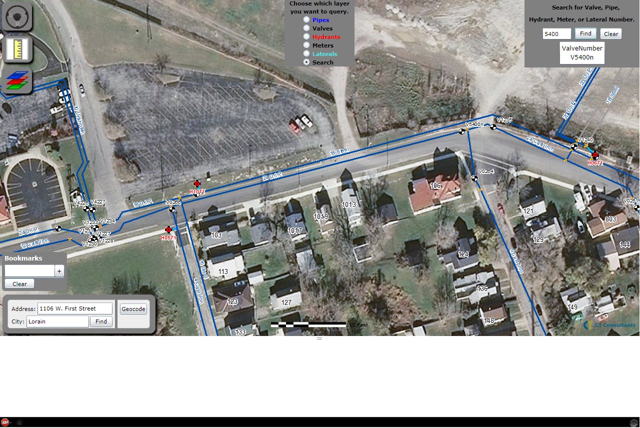
Here is the query request
http://XXXXXX/ArcGIS/rest/services/Water_Utilities_Map/MapServer/find?searchText=5400&contains=true&returnGeometry=true&sr=102100&searchFields=HydrantNumber%2cValveNumber%2cMeter_Number%2cLateral_Number%2cPipe_Number&layers=0%2c1%2c2%2c3%2c4%2c5%2c6%2c7%2c8&f=pjson&
Here is the response
{
  "results" : [
    {
      "layerId" : 1,
      "layerName" : "Valves",
      "displayFieldName" : "VALVENUMBER",
      "foundFieldName" : "ValveNumber",
      "value" : "V5400n",
      "attributes" : {
        "OBJECTID" : "4116",
        "ValveNumber" : "V5400n",
        "ValveType" : "Null",
        "YearInstalled" : "Null",
        "Manufacturer" : "Null",
        "Model" : "Null",
        "Ownership" : "Lorain",
        "DrawingSet_ID" : "2",
        "DwgSheet" : "1",
        "StartNode_ID" : "Null",
        "SHAPE" : "Point",
        "Enabled" : "True",
        "SOURCE_DESCRIPTION" : "Null",
        "FOLDER" : "Null",
        "Location" : "Null",
        "Turns" : "Null",
        "DirectionOpen" : "Null",
        "Valve_Diameter" : "Null"
      },
      "geometryType" : "esriGeometryPoint",
      "geometry" :
      {
        "x" : -9148438.16978488,
        "y" : 5081889.88472851,
        "spatialReference" : {
          "wkid" : 102100
        }
      }
    }
  ]
}
03-29-2012
06:38 AM
- Mark as New
- Bookmark
- Subscribe
- Mute
- Subscribe to RSS Feed
- Permalink
I do spatial queries on the features and it works fine.
Here is a spatial query working on water and adding graphics layers after i select an item in the listbox.
[ATTACH=CONFIG]13102[/ATTACH]
But when i do a find on the map service I get the results but no graphics are made once i select the item in the listbox.
[ATTACH=CONFIG]13103[/ATTACH]
Which sample would show me the easiest way to define a renderer at the client side to know if it's a rendering issue?