- Home
- :
- All Communities
- :
- Developers
- :
- ArcGIS API Silverlight (Retired)
- :
- ArcGIS API Silverlight Questions
- :
- Re: FeatureDataForm doesn`t show Domains anymore
- Subscribe to RSS Feed
- Mark Topic as New
- Mark Topic as Read
- Float this Topic for Current User
- Bookmark
- Subscribe
- Mute
- Printer Friendly Page
- Mark as New
- Bookmark
- Subscribe
- Mute
- Subscribe to RSS Feed
- Permalink
Hi,
recently I`ve taken over the development support of a larger silverlight mapping application in our company. Unfortunately there`s currently no one here who`s familiar with the application and I`ve to fix several Bugs after we migrated from ArcGIS Server 10 to 10.2.2.
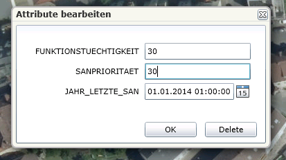
One problem belongs to a FeatureDataForm
<esri:FeatureDataForm Grid.Row="1" Grid.Column="0" x:Name="myFeatureDataForm" CommitButtonContent="OK" HorizontalAlignment="Left" ScrollViewer.VerticalScrollBarVisibility="Visible" ScrollViewer.HorizontalScrollBarVisibility="Visible" EditEnded="myFeatureDataForm_EditEnded"
IsReadOnly="False" LabelPosition="Left" Margin="5,5,5,5">
</esri:FeatureDataForm>
I initialize the form as follows:
FeatureLayer fl = getFeatureLayer(al.TabellenLayerID);
myFeatureDataForm.FeatureLayer = fl;
myFeatureDataForm.GraphicSource = fl.Graphics.First();
It references a table layer:
<esri:FeatureLayer ID="abschnittSanierungsbedarf" Url="/arcgis/rest/services/private/fis_deiche_event_layers_featureservice/FeatureServer/23"
ProxyUrl="../apps/fisdeiche/proxy.ashx"
DisableClientCaching="True"
AutoSave="False"
OutFields="FUNKTIONSTUECHTIGKEIT, SANPRIORITAET, JAHR_LETZTE_SAN"
Mode="OnDemand"
MaximumResolution="16"
/>
I get back domains from the server, see the following state during debugging:
?myFeatureDataForm.FeatureLayer.LayerInfo.Fields[5].Domain
{ESRI.ArcGIS.Client.FeatureService.CodedValueDomain}
[ESRI.ArcGIS.Client.FeatureService.CodedValueDomain]: {ESRI.ArcGIS.Client.FeatureService.CodedValueDomain}
Name: "FISD_SANIERUNG_FUNKTION"
But I don`t get drop downs with coded values in my panel.
The REST endpoint of this layer loos as follows:
Layer: GEWIS.GEW_HWD_SANFUNKBEDARF (ID: 23)
Name: GEWIS.GEW_HWD_SANFUNKBEDARF
Display Field: HWD_NR_TEXT
Type: Table
Geometry Type: N/A
Description:
Definition Expression: N/A
Copyright Text:
Default Visibility: false
MaxRecordCount: 10000
Supported Query Formats: JSON, AMF
Supports Advanced Queries: true
Supports Statistics: true
Use Standardized Queries: true
Extent:
Drawing Info:
N/A
HasZ: false
HasM: false
Has Attachments: false
HTML Popup Type: esriServerHTMLPopupTypeNone
Type ID Field:
Fields:
OBJECTID ( type: esriFieldTypeOID , alias: OBJECTID , editable: false , nullable: false )
HWD_NR ( type: esriFieldTypeDouble , alias: HWD_NR , editable: true , nullable: false )
BASISSTATIONIERUNG_VON ( type: esriFieldTypeInteger , alias: BASISSTATIONIERUNG_VON ,
editable: true , nullable: false )
BASISSTATIONIERUNG_BIS ( type: esriFieldTypeInteger , alias: BASISSTATIONIERUNG_BIS ,
editable: true , nullable: false )
ABSCHNITTLAENGE ( type: esriFieldTypeInteger , alias: ABSCHNITTLAENGE , editable: true ,
nullable: true )
FUNKTIONSTUECHTIGKEIT ( type: esriFieldTypeSmallInteger , alias: FUNKTIONSTUECHTIGKEIT ,
editable: true , nullable: true , Coded Values: [0: k.A.] , [10: n.s.bed.] , [20: saniert] , ...2 more...
)
SANPRIORITAET ( type: esriFieldTypeSmallInteger , alias: SANPRIORITAET , editable: true ,
nullable: true , Coded Values: [10: sehr hoch] , [20: hoch] , [30: mittel] , ...3 more... )
JAHR_LETZTE_SAN ( type: esriFieldTypeDate , alias: JAHR_LETZTE_SAN , editable: true , nullable:
true , length: 36 )
HWD_NR_TEXT ( type: esriFieldTypeString , alias: HWD_NR_TEXT , editable: true , nullable: true ,
length: 50 )
Templates:
Name: GEWIS.GEW_HWD_SANFUNKBEDARF
Description:
Prototype:
HWD_NR_TEXT: null
HWD_NR: 0
BASISSTATIONIERUNG_VON: 0
BASISSTATIONIERUNG_BIS: 0
ABSCHNITTLAENGE: null
FUNKTIONSTUECHTIGKEIT: null
SANPRIORITAET: null
JAHR_LETZTE_SAN: null
Drawing Tool: esriFeatureEditToolNone
Capabilities: Create, Delete,Query,Update,Uploads,Editing
Sync Can Return Changes: false
Is Data Versioned: false
Supports Rollback On Failure: true
Supported Operations: Query Apply Edits
Do you have any suggestions for me?
Thank you for help!
Solved! Go to Solution.
Accepted Solutions
- Mark as New
- Bookmark
- Subscribe
- Mute
- Subscribe to RSS Feed
- Permalink
Hi, sorry for my late answer. Yes I was able to solve it. Your layer will probably have an associated domain, please make sure your layer symbols are classified by this domain property. Then add a feature template to layer based on the domain calssification. Now if you publish the service you should have a "Types" section in your REST end point and your client problem should be solved.
- Mark as New
- Bookmark
- Subscribe
- Mute
- Subscribe to RSS Feed
- Permalink
We are seeing a similar issue running ArcGIS API 3.1. Were you able to resolve this?
- Mark as New
- Bookmark
- Subscribe
- Mute
- Subscribe to RSS Feed
- Permalink
Hi, sorry for my late answer. Yes I was able to solve it. Your layer will probably have an associated domain, please make sure your layer symbols are classified by this domain property. Then add a feature template to layer based on the domain calssification. Now if you publish the service you should have a "Types" section in your REST end point and your client problem should be solved.
- Mark as New
- Bookmark
- Subscribe
- Mute
- Subscribe to RSS Feed
- Permalink
Thanks for the reply -
We ended up modifying the FeatureDataForm control source code, rolling back the changes that where made between the version that was working for us and newer version. Rebuilt the dll and referenced our version instead. Haven't hear of any issues with that form since.