- Home
- :
- All Communities
- :
- Developers
- :
- JavaScript Maps SDK
- :
- JavaScript Maps SDK Questions
- :
- Re: Use Webservices with Arcgis API
- Subscribe to RSS Feed
- Mark Topic as New
- Mark Topic as Read
- Float this Topic for Current User
- Bookmark
- Subscribe
- Mute
- Printer Friendly Page
- Mark as New
- Bookmark
- Subscribe
- Mute
- Subscribe to RSS Feed
- Permalink
Hi
Any one can help to pick my mistakes in given code. In web console data is showing but it's not displaying on map.
<!DOCTYPE html>
<html>
<head>
<meta charset="utf-8" />
<meta
name="viewport"
content="initial-scale=1,maximum-scale=1,user-scalable=no"
/>
<title>GeoJSONLayer - 4.12</title>
<style>
html,
body,
#viewDiv {
padding: 0;
margin: 0;
height: 100%;
width: 100%;
}
</style>
<link
rel="stylesheet"
href="https://js.arcgis.com/4.12/esri/themes/light/main.css"
/>
<script src="https://js.arcgis.com/4.12/"></script>
<script>
require([
"esri/Map",
"esri/views/MapView",
"esri/request",
"esri/Graphic",
"esri/geometry/Point",
"esri/layers/FeatureLayer",
], function(Map, MapView, esriRequest, Graphic,Point, FeatureLayer) {
const url ="http://localhost:5000"
const map = new Map({
basemap: "satellite",
});
const view = new MapView({
container: "viewDiv",
center: [67.068037, 24.872328],
zoom: 12,
map: map
});
const fields = [
{
name: "ObjectID",
alias: "ObjectID",
type: "oid"
},
{
name: "Name",
alias: "Name",
type: "string"
},
{
name: "FAT",
alias: "FAT",
type: "string"
},
{
name: "Type",
alias: "Type",
type: "string"
},
{
name: "DC",
alias: "DC",
type: "string"
},
{
name: "ID",
alias: "ID",
type: "string"
},
{
name: "POP",
alias: "POP",
type: "string"
}
];
const pTemplate = {
title: "{title}",
content: [
{
type: "fields",
fieldInfos: [
{
fieldName: "Name",
label: "Name",
visible: true
},
{
fieldName: "FAT",
label: "FAT",
visible: true
},
{
fieldName: "Type",
label: "Type",
visible: true
},
{
fieldName: "DC",
label: "DC",
visible: true
},
{
fieldName: "ID",
label: "ID",
visible: true
},
{
fieldName: "POP",
label: "POP",
visible: true,
format: {
digitSeparator: true,
places: 0
}
}
]
}
]
};
const dataRenderer = {
type: "simple",
symbol : {
type: "simple-marker",
color: "blue",
size: 3,
outline: { // autocasts as new SimpleLineSymbol()
width: 0.5,
color: [0, 0, 0, 0.2]
}
},
}
var options = {
query: {
f: "json"
},
responseType: "json"
};
esriRequest(url, options).then(webservice)
function webservice(response){
var graphicsArray = response.data.map(function(result){
//console.log(result)
var resultPnts = result.SHAPE.points.map(function(point){
return new Point({
x:point.x,
y:point.y,
spatialReference : result.SHAPE.srid
});
})
var atts = {
"ObjectID": result.OBJECTID,
"Splitter": result.Splitter,
"Comment": result.Comment,
"Name": result.Name,
"ID": result.ID,
"Placement": result.Placement,
"POP": result.POP
};
var graArr = resultPnts.map(function(pnt){
var markerSymbol = {
type: "simple-marker", // autocasts as new SimpleMarkerSymbol()
color: [226, 119, 40]
};
return new Graphic({
geometry:pnt,
symbol: markerSymbol,
attributes: atts
})
})
return graArr
})
//console.log(graphicsArray)
const layer = new FeatureLayer({
geometryType: "point",
source: [graphicsArray],
fields: fields,
objectIdField: "ObjectID",
renderer: dataRenderer,
popupTemplate: pTemplate
});
map.add(layer);
}
});
</script>
</head>
<body>
<div id="viewDiv"></div>
</body>
</html>
Solved! Go to Solution.
- Mark as New
- Bookmark
- Subscribe
- Mute
- Subscribe to RSS Feed
- Permalink
Robert,
There is no return in my console.log....
Can i use variable outSpatialReference in point object instead of result.SHAPE.srid..??
function webservice(response){
const outSpatialReference = new SpatialReference({
wkid: 32642
});
var graphicsArray = response.data.map(function(result){
//console.log(result)
var resultPnts = result.SHAPE.points.map(function(point){
return new Point({
x:point.x,
y:point.y,
spatialReference : result.SHAPE.srid
});
})
var atts = {
"ObjectID": result.OBJECTID,
"Splitter": result.Splitter,
"Comment": result.Comment,
"Name": result.Name,
"ID": result.ID,
"Placement": result.Placement,
"POP": result.POP
};
var graArr = resultPnts.map(function(pnt){
var projectedPoint = projection.project(pnt,outSpatialReference);
var markerSymbol = {
type: "simple-marker", // autocasts as new SimpleMarkerSymbol()
color: [226, 119, 40]
};
var graphic = new Graphic({
geometry:projectedPoint,
symbol: markerSymbol,
attributes: atts
})
console.log(graphic)
})
return graArr
})- Mark as New
- Bookmark
- Subscribe
- Mute
- Subscribe to RSS Feed
- Permalink
Kawish,
You want to project the points to the view.spatialReference (which will be 102100). Right now you are you are asking it to project to same WKDI as the data is already in...
Corrected code:
const outSpatialReference = new SpatialReference({
wkid: view.spatialReference
});Also Have you called
projection.load()earlier in your code?
- Mark as New
- Bookmark
- Subscribe
- Mute
- Subscribe to RSS Feed
- Permalink
Robert,
Full code is mentioned below. I received same error in my console
<!DOCTYPE html>
<html>
<head>
<meta charset="utf-8" />
<meta
name="viewport"
content="initial-scale=1,maximum-scale=1,user-scalable=no"
/>
<title>JSON</title>
<style>
html,
body,
#viewDiv {
padding: 0;
margin: 0;
height: 100%;
width: 100%;
}
</style>
<link
rel="stylesheet"
href="https://js.arcgis.com/4.12/esri/themes/light/main.css"
/>
<script src="https://js.arcgis.com/4.12/"></script>
<script>
require([
"esri/Map",
"esri/views/MapView",
"esri/request",
"esri/Graphic",
"esri/geometry/Point",
"esri/layers/FeatureLayer",
"esri/geometry/projection",
"esri/geometry/SpatialReference"
], function(Map, MapView, esriRequest, Graphic,Point, FeatureLayer, projection, SpatialReference) {
projection.load()
let url ="http://localhost:5000"
let fields = [
{
name: "ObjectID",
alias: "ObjectID",
type: "oid"
},
{
name: "Name",
alias: "Name",
type: "string"
},
{
name: "FAT",
alias: "FAT",
type: "string"
},
{
name: "Type",
alias: "Type",
type: "string"
},
{
name: "DC",
alias: "DC",
type: "string"
},
{
name: "ID",
alias: "ID",
type: "string"
},
{
name: "POP",
alias: "POP",
type: "string"
}
];
let pTemplate = {
title: "{title}",
content: [
{
type: "fields",
fieldInfos: [
{
fieldName: "Name",
label: "Name",
visible: true
},
{
fieldName: "FAT",
label: "FAT",
visible: true
},
{
fieldName: "Type",
label: "Type",
visible: true
},
{
fieldName: "DC",
label: "DC",
visible: true
},
{
fieldName: "ID",
label: "ID",
visible: true
},
{
fieldName: "POP",
label: "POP",
visible: true,
format: {
digitSeparator: true,
places: 0
}
}
]
}
]
};
let dataRenderer = {
type: "simple",
symbol : {
type: "simple-marker",
color: "blue",
size: 3,
outline: { // autocasts as new SimpleLineSymbol()
width: 0.5,
color: [0, 0, 0, 0.2]
}
},
}
let map = new Map({
basemap: "satellite",
});
let view = new MapView({
container: "viewDiv",
center: [67.068037, 24.872328],
zoom: 12,
map: map
});
let options = {
query: {
f: "json"
},
responseType: "json"
};
let fetchData = () => esriRequest(url, options).then(response => response.data)
let webservice = res => {
let graphicsArray = res.map(function(result){
let resultPnts = result.SHAPE.points.map(function(point){
return new Point({
x:point.x,
y:point.y,
spatialReference : result.SHAPE.srid
});
})
let atts = {
"ObjectID": result.OBJECTID,
"Splitter": result.Splitter,
"Comment": result.Comment,
"Name": result.Name,
"ID": result.ID,
"Placement": result.Placement,
"POP": result.POP
};
let graArr = resultPnts.map(function(pnt){
let projectedPoint = projection.project(pnt,view.spatialReference);
let markerSymbol = {
type: "simple-marker", // autocasts as new SimpleMarkerSymbol()
color: [226, 119, 40]
};
return new Graphic({
geometry:projectedPoint,
symbol: markerSymbol,
attributes: atts
})
//console.log(graphic)
})
return graArr
})
console.log(graphicsArray)
let layer = new FeatureLayer({
geometryType: "point",
source: [graphicsArray],
fields: fields,
objectIdField: "ObjectID",
renderer: dataRenderer,
popupTemplate: pTemplate
});
map.add(layer)
}
view.when(() =>{
fetchData()
.then(webservice)
})
});
</script>
</head>
<body>
<div id="viewDiv"></div>
</body>
</html>
This is response of my data that i received in console..
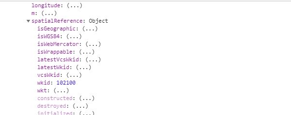
I want to discuss one more thing. When i use geojson service(http://localhost:5000/geojson ) instead of json service(http://localhost:5000) the above code is working well. Why its not working on json service.
Result of geojson service.

- Mark as New
- Bookmark
- Subscribe
- Mute
- Subscribe to RSS Feed
- Permalink
Kawish,
Looks like you problem most likely is your feature layer source.
You are wrapping the array in square brackets which means an array inside and array.
(line 3 square brackets removed).
let layer = new FeatureLayer({
geometryType: "point",
source: graphicsArray,
fields: fields,
objectIdField: "ObjectID",
renderer: dataRenderer,
popupTemplate: pTemplate
});As for your other question I am not sure. based on the web console it seems the geojson endpoint is returning wkid 4326 instead.
- Mark as New
- Bookmark
- Subscribe
- Mute
- Subscribe to RSS Feed
- Permalink
Thank you Robert,
error occurs because of an array inside and array. I create an empty array with name myData and push graphic object into myData then call its instance in FeatureLayer. Its working well.
let myData = [];
let g = new Graphic({
geometry:projectedPoint,
symbol: markerSymbol,
attributes: atts
})
myData.push(g)
let layer = new FeatureLayer({
geometryType: "point",
source: myData,
fields: fields,
objectIdField: "ObjectID",
renderer: dataRenderer,
popupTemplate: pTemplate
});- Mark as New
- Bookmark
- Subscribe
- Mute
- Subscribe to RSS Feed
- Permalink
Don't forget to mark this question as answered by clicking on the "Mark Correct" link on the reply that answered your question.
- « Previous
-
- 1
- 2
- Next »
- « Previous
-
- 1
- 2
- Next »