- Home
- :
- All Communities
- :
- Developers
- :
- JavaScript Maps SDK
- :
- JavaScript Maps SDK Questions
- :
- Proper Use of geometryEngine.geodesicBuffer?
- Subscribe to RSS Feed
- Mark Topic as New
- Mark Topic as Read
- Float this Topic for Current User
- Bookmark
- Subscribe
- Mute
- Printer Friendly Page
- Mark as New
- Bookmark
- Subscribe
- Mute
- Subscribe to RSS Feed
- Permalink
Been learning how to use the ArcGIS Javascript API v4.9. But despite the countless examples online, I keep into bumping into seemingly "small" things that just don't work. For example, creating a buffer around a point and then adding that buffer to a graphics layer. I've used the code here which works for me, and have stripped it down to the minimum in hopes of adapting it to what I'm working on. But now I'm getting this error:
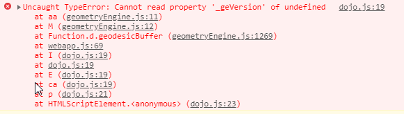
What is the "_geVersion" - a reference to geometry engine version? Why is that undefined? Any pointers are appreciated.My point is added to the map just fine. The buffer is what I'm trying to get working. Here is my code:
Solved! Go to Solution.
Accepted Solutions
- Mark as New
- Bookmark
- Subscribe
- Mute
- Subscribe to RSS Feed
- Permalink
Arne,
The issue is that GeometryEngine does not autoCast the geometry property and you are only providing an object and not an actual geometry class like Point class.
- Mark as New
- Bookmark
- Subscribe
- Mute
- Subscribe to RSS Feed
- Permalink
Arne,
The issue is that GeometryEngine does not autoCast the geometry property and you are only providing an object and not an actual geometry class like Point class.
- Mark as New
- Bookmark
- Subscribe
- Mute
- Subscribe to RSS Feed
- Permalink
Nice! I knew I was missing something simple...Thanks, Robert!
Tweaked as per below, and not it works: