- Home
- :
- All Communities
- :
- Developers
- :
- JavaScript Maps SDK
- :
- JavaScript Maps SDK Questions
- :
- Maximum Image Height/Width issue
- Subscribe to RSS Feed
- Mark Topic as New
- Mark Topic as Read
- Float this Topic for Current User
- Bookmark
- Subscribe
- Mute
- Printer Friendly Page
Maximum Image Height/Width issue
- Mark as New
- Bookmark
- Subscribe
- Mute
- Subscribe to RSS Feed
- Permalink
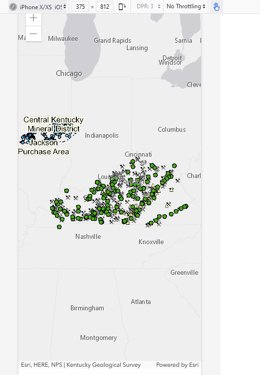
This isn't a question, but something that I just found while working with the Javascript API 4.14. I have a map application that when I added certain layers from our ArcGIS Server 10.61 as a MapImageLayer, some layers would render offset when viewed in Safari or an iPhone X/Xs (see attached images from an emulator in Chrome). I think most other browsers/operating systems worked fine. After messing around with this for awhile and comparing services that worked with the ones that did not, I found that the ones that did not had the Maximum Image Height and Width set in ArcGIS Server at 2048 whereas the ones that did work were set at the higher 4096. So, simply upping the Maximum Image Height and Width of my 2048 services to 4096 in the ArcGIS Server Manager fixed the issue. I don't know if this is a bug with the Javascript API for these devices/browsers - I will say that these layers rendered fine with my Javascript API 3.x applications in Safari and iPhone X/Xs. Thought I would mention this here in case anyone else ran across the same issue. I'd love to know why this happens though.
Attached are 2 images - one is the before - you will see the layer offset from KY in the iPhoneX emulator - this was before I changed the Max Height/Width settings in ArcGIS Server Manager. The other is after I upped the setting to 4096.