- Home
- :
- All Communities
- :
- Developers
- :
- JavaScript Maps SDK
- :
- JavaScript Maps SDK Questions
- :
- Re: How do you get renderer from a feature layer?
- Subscribe to RSS Feed
- Mark Topic as New
- Mark Topic as Read
- Float this Topic for Current User
- Bookmark
- Subscribe
- Mute
- Printer Friendly Page
How do you get renderer from a feature layer?
- Mark as New
- Bookmark
- Subscribe
- Mute
- Subscribe to RSS Feed
- Permalink
- Report Inappropriate Content
How do you get the renderer from a feature layer?
I want to get the current rendered from a feature layer, and then set the RotationInfo on it so I can rotate my graphics that are in that feature service.
Solved! Go to Solution.
Accepted Solutions
- Mark as New
- Bookmark
- Subscribe
- Mute
- Subscribe to RSS Feed
- Permalink
- Report Inappropriate Content
Morgan,
Here is a simple sample.
<!DOCTYPE html>
<html>
  <head>
    <meta http-equiv="Content-Type" content="text/html; charset=utf-8">
    <meta name="viewport" content="initial-scale=1, maximum-scale=1,user-scalable=no">
    <title>Feature Layer Only Map</title>
    <link rel="stylesheet" href="http://js.arcgis.com/3.13/esri/css/esri.css">
    <style>
      html, body, #map {
        height: 100%;
        width: 100%;
        margin: 0;
        padding: 0;
      }
    </style>
    <script src="http://js.arcgis.com/3.13/"></script>
    <script>
      require([
        "dojo/dom-construct",
        "esri/map",
        "esri/layers/FeatureLayer",
        "esri/geometry/Extent",
        "esri/InfoTemplate",
        "dojo/domReady!"
      ], function(
          domConstruct,
          Map,
          FeatureLayer,
          Extent,
          InfoTemplate
        ) {
          var bounds = new Extent({
            "xmin":-16045622,
            "ymin":-811556,
            "xmax":7297718,
            "ymax":11142818,
            "spatialReference":{"wkid":102100}
          });

          var map = new Map("map", {
            extent: bounds
          });

          var url = "http://sampleserver6.arcgisonline.com/arcgis/rest/services/WorldTimeZones/MapServer/2";

          var template = new InfoTemplate("World Regions", "Region: ${REGION}");

          var fl = new FeatureLayer(url, {
            id: "world-regions",
            infoTemplate: template
          });
          fl.on('load', function(evt){
            console.info(evt.target.renderer);
          });

          map.addLayer(fl);
        }
      );
    </script>
  </head>
  <body>
    <div id="map"></div>
  </body>
</html>
- Mark as New
- Bookmark
- Subscribe
- Mute
- Subscribe to RSS Feed
- Permalink
- Report Inappropriate Content
The renderer is a property of the featureLayer so:
var theRenderer = theLayer.renderer;
- Mark as New
- Bookmark
- Subscribe
- Mute
- Subscribe to RSS Feed
- Permalink
- Report Inappropriate Content
I've tried that, it is null every time. Or am I looking at it at the wrong time?
- Mark as New
- Bookmark
- Subscribe
- Mute
- Subscribe to RSS Feed
- Permalink
- Report Inappropriate Content
When are you trying to get the renderer? You're probably trying to access it before it's ready. Try setting that after the FeatureLayer's load event fires.
- Mark as New
- Bookmark
- Subscribe
- Mute
- Subscribe to RSS Feed
- Permalink
- Report Inappropriate Content
Morgan,
Here is a simple sample.
<!DOCTYPE html>
<html>
  <head>
    <meta http-equiv="Content-Type" content="text/html; charset=utf-8">
    <meta name="viewport" content="initial-scale=1, maximum-scale=1,user-scalable=no">
    <title>Feature Layer Only Map</title>
    <link rel="stylesheet" href="http://js.arcgis.com/3.13/esri/css/esri.css">
    <style>
      html, body, #map {
        height: 100%;
        width: 100%;
        margin: 0;
        padding: 0;
      }
    </style>
    <script src="http://js.arcgis.com/3.13/"></script>
    <script>
      require([
        "dojo/dom-construct",
        "esri/map",
        "esri/layers/FeatureLayer",
        "esri/geometry/Extent",
        "esri/InfoTemplate",
        "dojo/domReady!"
      ], function(
          domConstruct,
          Map,
          FeatureLayer,
          Extent,
          InfoTemplate
        ) {
          var bounds = new Extent({
            "xmin":-16045622,
            "ymin":-811556,
            "xmax":7297718,
            "ymax":11142818,
            "spatialReference":{"wkid":102100}
          });

          var map = new Map("map", {
            extent: bounds
          });

          var url = "http://sampleserver6.arcgisonline.com/arcgis/rest/services/WorldTimeZones/MapServer/2";

          var template = new InfoTemplate("World Regions", "Region: ${REGION}");

          var fl = new FeatureLayer(url, {
            id: "world-regions",
            infoTemplate: template
          });
          fl.on('load', function(evt){
            console.info(evt.target.renderer);
          });

          map.addLayer(fl);
        }
      );
    </script>
  </head>
  <body>
    <div id="map"></div>
  </body>
</html>
- Mark as New
- Bookmark
- Subscribe
- Mute
- Subscribe to RSS Feed
- Permalink
- Report Inappropriate Content
Robert, that worked perfectly.
Thanks.
- Mark as New
- Bookmark
- Subscribe
- Mute
- Subscribe to RSS Feed
- Permalink
- Report Inappropriate Content
Robert,
does this solution works only with simple symbology?
I tried this with my current code and it returned the same result i have here:
renderer from an existing service fails to return the full symbology
with the symbology as you can see in the pictures not fully operational when its "complicated".
any ideas?
- Mark as New
- Bookmark
- Subscribe
- Mute
- Subscribe to RSS Feed
- Permalink
- Report Inappropriate Content
No it should work with any renderer.
- Mark as New
- Bookmark
- Subscribe
- Mute
- Subscribe to RSS Feed
- Permalink
- Report Inappropriate Content
im trying to do the same with a uniqeValue renderer from a public service, and the code seems to get me the renderer and the attribute field, but on rendering i get a bad result.
this is the code:
var serviceUrl = "https://ags.iplan.gov.il/arcgisiplan/rest/services/PlanningPublic/Xplan_2039/MapServer/1";
var layer = new FeatureLayer(serviceUrl);
if (featureLayer.graphics) {
layer.on('load', function(evt){
console.info(evt.target.renderer);
featureLayer.setRenderer(evt.target.renderer)
});
it gets me:
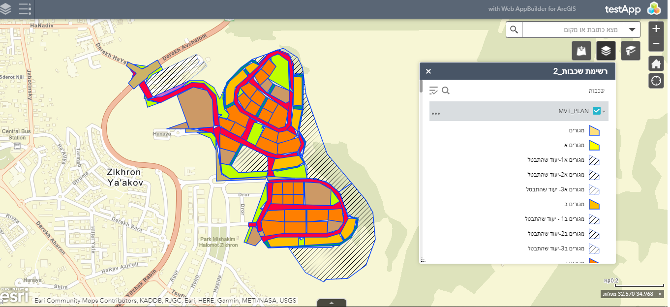
instead of: im trying to get why the original service im taking the renderer from has a different symbology than mine,
from service:

from the code:

- Mark as New
- Bookmark
- Subscribe
- Mute
- Subscribe to RSS Feed
- Permalink
- Report Inappropriate Content
Segev,
There is some hatching symbology that is not supported on ArcGIS server services and normally you are warned of this when you publish the service.