- Home
- :
- All Communities
- :
- Developers
- :
- JavaScript Maps SDK
- :
- JavaScript Maps SDK Questions
- :
- Best way (if possible) to load png/tiff with sampl...
- Subscribe to RSS Feed
- Mark Topic as New
- Mark Topic as Read
- Float this Topic for Current User
- Bookmark
- Subscribe
- Mute
- Printer Friendly Page
Best way (if possible) to load png/tiff with sampling capabilities
- Mark as New
- Bookmark
- Subscribe
- Mute
- Subscribe to RSS Feed
- Permalink
I have a dataset that is either in geotiff or georeferenced png format, same data. Currently I use the png format with MapImageLayer and load the data atop the background map (see below). It works, but I'd really like to enhance it if possible, in two ways.
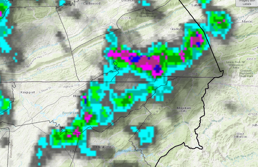
1. Most importantly, I like to have the capability to sample the data. The data is precipitation and the color scale is defined to a set range, thus if I could sample the RGB, then that could be converted to a cursor readout of precipitation range. This would require using canvas I think, and I'm not sure if that's doable with MapImageLayer. The second option would be to somehow load the raw geotiff for sampling. This would be easy if it was an online map service, however I need to sample the raw geotiff on the host server, thus a local file relative to the application. Therefore, what if any route should I take to accomplish sampling and a cursor readout? Or am I just out of luck?
2. The png format looks pretty good overall, however when zooming the image is blurry, which makes sense. Is there a better way to handle this? Will increasing the resolution of the image help at all?
Thanks!