Turn on suggestions
Auto-suggest helps you quickly narrow down your search results by suggesting possible matches as you type.
Cancel
- Home
- :
- All Communities
- :
- Developers
- :
- ArcGIS API for Flex (Retired)
- :
- ArcGIS API for Flex Questions
- :
- Use Parameter of Choice List for GP Service
Options
- Subscribe to RSS Feed
- Mark Topic as New
- Mark Topic as Read
- Float this Topic for Current User
- Bookmark
- Subscribe
- Mute
- Printer Friendly Page
Use Parameter of Choice List for GP Service
Subscribe
5632
10
05-26-2011 03:58 AM
05-26-2011
03:58 AM
- Mark as New
- Bookmark
- Subscribe
- Mute
- Subscribe to RSS Feed
- Permalink
Hey everybody,
i'm trying to implement a flex web application, which uses a geoprocessing service.
This GP Service needs a FeatureLayer/FeatureDataSet as input, before it can run.
I tried different ways to deliver the parameter, but it doesn't work.
Attached you'll find my code. I hope that somebody can find the mistake.
Probably the mistake is in this line:
Is it possible to use a file out of the local file system of the webserver?
Additionally i have uploaded 4 Layers in the MapDocument together with the Toolbox/GP Service, so as you can see in the screenshot i have a choice list.
How can i choose one layer of the choice list and forward this to the GP Service ?
And most important question: What i am doing wrong? 🙂
Best regards
Stefan
i'm trying to implement a flex web application, which uses a geoprocessing service.
This GP Service needs a FeatureLayer/FeatureDataSet as input, before it can run.
I tried different ways to deliver the parameter, but it doesn't work.
Attached you'll find my code. I hope that somebody can find the mistake.
Probably the mistake is in this line:
var params:Object = "http://wk2658/ArcGIS/rest/services/scotturb/FeatureServer/0":featureSet;
Is it possible to use a file out of the local file system of the webserver?
Additionally i have uploaded 4 Layers in the MapDocument together with the Toolbox/GP Service, so as you can see in the screenshot i have a choice list.
How can i choose one layer of the choice list and forward this to the GP Service ?
And most important question: What i am doing wrong? 🙂
Best regards
Stefan
10 Replies
by
Anonymous User
Not applicable
05-26-2011
11:41 PM
- Mark as New
- Bookmark
- Subscribe
- Mute
- Subscribe to RSS Feed
- Permalink
Original User: ibespalov
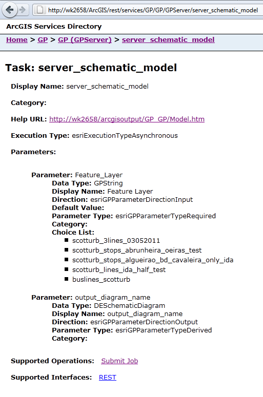
screen1.png contains all information you need to submit jobs
your parameter name is "Feature_Layer" and its value is one of presented in list of choice and its type is GPString
Do you now anything about ArcGIS API for Flex Samples (6 GP tasks samples)
You can find very helpful information about ArcGIS Server REST API (with samples) http://yourservername/ArcGIS/SDK/REST/index.html?gpserver.html
Good luck.
screen1.png contains all information you need to submit jobs
your parameter name is "Feature_Layer" and its value is one of presented in list of choice and its type is GPString
var paramName:String = "Feature_Layer";
var paramValue:String = "scotturb_3lines_03052011";

var params:Object = { paramName: paramValue };
var params:Object = "http://wk2658/ArcGIS/rest/services/scotturb/FeatureServer/0":featureSet;
:confused:
Who teached you to do it so?
Do you now anything about ArcGIS API for Flex Samples (6 GP tasks samples)
You can find very helpful information about ArcGIS Server REST API (with samples) http://yourservername/ArcGIS/SDK/REST/index.html?gpserver.html
Good luck.
05-27-2011
03:25 AM
- Mark as New
- Bookmark
- Subscribe
- Mute
- Subscribe to RSS Feed
- Permalink
Dear Ivan,
thank you a lot for your answer!
Nobody told me to do it like that, i tried to learn it for myself the last days and weeks.
I had a look at all the samples, watched some Tutorial-videos and read the affected API pages, but you saw the result 🙂
Even if it not looks like this, i spent already 1-2 Weeks on this problem.
So i was very happy to read your post and excited to try it out, but sadly it's still not working.
When i just enter the ValueName in the submitJob REST Service Directory (see 19.png) it works perfectly.
But when i click on the button in my widget, nothing happens.
I Added an Example-Alert to see if the function is called and the end of it is reached, this was successfull.
Is the order of the code correct? "fx:Script", then "fx:Declarations" and then the viewer:WidgetTemplate ? ( Full code attached: schematics_widget.txt).
You told me that the type is "GPString" like i can see it in the screen1.png, but you wrote just "var paramName:String" ? Why? After i tried to change String in GPString there was an error, so i think your code was correct.
:confused:
by
Anonymous User
Not applicable
05-27-2011
04:27 AM
- Mark as New
- Bookmark
- Subscribe
- Mute
- Subscribe to RSS Feed
- Permalink
Original User: ibespalov
This is not my source code. This is part of DataExtractWidget.mxml source code in last Flex Viewer changed by me.
Some times ago I did small project (used GP service) based on flex viewer code - it works fine.
You must read more ESRI help and explore API reference to implement your Geoprocessor result handler.
Try to use Fiddler (for IE) or Firebug (for FF) to see actions on the background of you application (sometime it helps).
...
private function gp_jobCompleteHandler(event:GeoprocessorEvent):void
{
    if (event.jobInfo.jobStatus == JobInfo.STATUS_SUCCEEDED)
    {
        // your output parameter name find in screen1.png !!!NOT Display name!!!
        gp.getResultData(gp.submitJobLastResult.jobId, "output_diagram_name");
    }
    else
    {
        // do something
    }
}

private function gp_getResultDataCompleteHandler(event:GeoprocessorEvent):void
{
    if (event.parameterValue)
    {
        // get your output result here
        dataUrl = String(event.parameterValue.value.url);

        if (!dataUrl)
        {
            Alert.show(emptyResultsLabel, wTemplate.widgetTitle);
            return;
        }

        Alert.show(saveDataFileLabel, wTemplate.widgetTitle, Alert.YES | Alert.NO, null, alert_ClickHandler);
    }
    else
    {
        Alert.show(emptyResultsLabel, wTemplate.widgetTitle);
    }
}

private function gp_faultHandler(event:FaultEvent):void
{
    // do something
}

private function alert_ClickHandler(event:CloseEvent):void
{
    if (event.detail == Alert.YES)
    {
        // do something
    }
}

]]>
</fx:Script>

<fx:Declarations>
    <esri:Geoprocessor id="gp"
            url="http://wk2658/ArcGIS/rest/services/GP/GP/GPServer/server_schematic_model"
            showBusyCursor="true"
            fault="gp_faultHandler(event)"
            getResultDataComplete="gp_getResultDataCompleteHandler(event)"
            jobComplete="gp_jobCompleteHandler(event)"/>
</fx:Declarations>
This is not my source code. This is part of DataExtractWidget.mxml source code in last Flex Viewer changed by me.
Some times ago I did small project (used GP service) based on flex viewer code - it works fine.
You must read more ESRI help and explore API reference to implement your Geoprocessor result handler.
Try to use Fiddler (for IE) or Firebug (for FF) to see actions on the background of you application (sometime it helps).
05-27-2011
05:43 AM
- Mark as New
- Bookmark
- Subscribe
- Mute
- Subscribe to RSS Feed
- Permalink
Hey Ivan!
Thanks again!
I think most of the code is very usefull for a real application, but in my case i would like to keep it as simple as possible. Just submit the Job in the most simple Code as possible. But of course i'm very thankful of this and i tried it and edited it but the error was the same as shown below.
But the Hint with Firebug was a very good idea!
I found out that the outgoing request looks like
So i can see that the Parameters are correct.
But the Response of the server is not correct. It says:
I'll try to figure out why.
If somebody has an idea in the meanwhile: I'm amenable to advices
Thanks again!
I think most of the code is very usefull for a real application, but in my case i would like to keep it as simple as possible. Just submit the Job in the most simple Code as possible. But of course i'm very thankful of this and i tried it and edited it but the error was the same as shown below.
But the Hint with Firebug was a very good idea!
I found out that the outgoing request looks like
http://wk2658/ArcGIS/rest/services/GP/GP/GPServer/server_schematic_model/submitJob?paramName=scotturb%5Flines%5Fida%5Fhalf%5Ftest&f=json
So i can see that the Parameters are correct.
But the Response of the server is not correct. It says:
{"error":{"code":500,"message":"GPTask 'server_schematic_model' does not exist or is inaccessible.","details":[]}}I'll try to figure out why.
If somebody has an idea in the meanwhile: I'm amenable to advices
by
Anonymous User
Not applicable
05-27-2011
06:27 AM
- Mark as New
- Bookmark
- Subscribe
- Mute
- Subscribe to RSS Feed
- Permalink
Original User: ibespalov
No, params are not correct!
Something wrong.
No, params are not correct!
Something wrong.
.../wk2658/ArcGIS/rest/services/GP/GP/GPServer/server_schematic_model/submitJob?paramName=scotturb%5Flines%5Fida%5Fhalf%5Ftest&f=json
must be something like:
.../wk2658/ArcGIS/rest/services/GP/GP/GPServer/server_schematic_model/submitJob?Feature_Layer=scotturb%5Flines%5Fida%5Fhalf%5Ftest&f=json
05-27-2011
06:34 AM
- Mark as New
- Bookmark
- Subscribe
- Mute
- Subscribe to RSS Feed
- Permalink
YES! You're right!
When i enter this link in my Browser it works!
Thank you very very much for you help!
When i enter this link in my Browser it works!
Thank you very very much for you help!
by
Anonymous User
Not applicable
05-27-2011
06:46 AM
- Mark as New
- Bookmark
- Subscribe
- Mute
- Subscribe to RSS Feed
- Permalink
05-27-2011
07:09 AM
- Mark as New
- Bookmark
- Subscribe
- Mute
- Subscribe to RSS Feed
- Permalink
But very strange that the URL was not created correctly. Difficult to find this error. Because the code looks correct.
But when i manually replace the parameters it works:
Otherwise the first Variable in the braces {} is not replaced by the Variable.
This is the reason why there was "paramName" instead of "Feature_Layer" in the Request.
When i switch paramName and paramValue the "FeatureLayer" is replaced corretly, but paramValue not any more.
Strange, but i think this is not a big problem any more.
 var paramName:String = "Feature_Layer";
 var paramValue:String = "scotturb_lines_ida_half_test";
 var params:Object = { paramName : paramValue };
But when i manually replace the parameters it works:
var params:Object = { "Feature_Layer" : "scotturb_lines_ida_half_test" };
Otherwise the first Variable in the braces {} is not replaced by the Variable.
This is the reason why there was "paramName" instead of "Feature_Layer" in the Request.
When i switch paramName and paramValue the "FeatureLayer" is replaced corretly, but paramValue not any more.
Strange, but i think this is not a big problem any more.
06-24-2011
03:40 AM
- Mark as New
- Bookmark
- Subscribe
- Mute
- Subscribe to RSS Feed
- Permalink
Hi,
just in addition to my last problem a little question:
I've already shown you my function, which uses a parameter out of the coice list:
And it works.
But when i want to use a shapefile, which is not in the choice list (screen1.png from Ivan), for example with a full absolute path like "C:\arcgisserver\....\testfile" it doesnt work. But i want to learn more about geoprocessing services and would like to know why this doesn't work.
Can somebody explain it to me? What should i change (or do differently) to make it working?
Why can't he access the file?
The error message when i want to use it looks like:
just in addition to my last problem a little question:
I've already shown you my function, which uses a parameter out of the coice list:
private function generateDiagram():void
   {
    var paramName:String = "Feature_Layer";
    var paramValue:String = "scotturb_lines_ida_half_test";
    var params:Object = { paramName : paramValue };
    gp2.submitJob(params);
   }
And it works.
But when i want to use a shapefile, which is not in the choice list (screen1.png from Ivan), for example with a full absolute path like "C:\arcgisserver\....\testfile" it doesnt work. But i want to learn more about geoprocessing services and would like to know why this doesn't work.
Can somebody explain it to me? What should i change (or do differently) to make it working?
Why can't he access the file?
The error message when i want to use it looks like:
"description":"The value does not exist.
ERROR 000732: Input locations: Dataset C:/arcgisserver/arcgisinput/testfile does not exist or is not supported"