- Home
- :
- All Communities
- :
- Developers
- :
- ArcGIS API for Flex (Retired)
- :
- ArcGIS API for Flex Questions
- :
- Re: Date and Time Data Extract Output Name
- Subscribe to RSS Feed
- Mark Topic as New
- Mark Topic as Read
- Float this Topic for Current User
- Bookmark
- Subscribe
- Mute
- Printer Friendly Page
Date and Time Data Extract Output Name
- Mark as New
- Bookmark
- Subscribe
- Mute
- Subscribe to RSS Feed
- Permalink
I would like to ask how to change the name of the resulting data extract into the current date and time??? thanks master..
outputFileName = (configXML.outputfilename[0] || "yyyy-MMM-dd-HHmmss") + ".zip";
outputFileName = outputFileName.replace(/(\\|\/|:|\?|"|<|>|\|)/g, "");- Mark as New
- Bookmark
- Subscribe
- Mute
- Subscribe to RSS Feed
- Permalink
Mr. Robert
i've tried to source code, but the error.
outputFileName = (configXML.outputfilename[0] || formatDate.format(new Date)) + formatDDL.selectedItem.data.substring(format.lastIndexOf(".") + 1, formatDDL.selectedItem.data.length) + ".zip";
- Mark as New
- Bookmark
- Subscribe
- Mute
- Subscribe to RSS Feed
- Permalink
Ahmad,
So did you add:
<mx:DateFormatter id="formatDate" formatString="YYYY-MMM-DD-LNNSS" />- Mark as New
- Bookmark
- Subscribe
- Mute
- Subscribe to RSS Feed
- Permalink
Mr. Robert,
i've add,
<mx:DateFormatter id="formatDate" formatString="YYYY-MMM-DD-LNNSS" />but,

- Mark as New
- Bookmark
- Subscribe
- Mute
- Subscribe to RSS Feed
- Permalink
Ahmad,
OK I see the issue. Try this:
outputFileName = (configXML.outputfilename[0] || formatDate.format(new Date)) + formatDDL.selectedItem.data.substring(formatDDL.selectedItem.data.lastIndexOf(".") + 1, formatDDL.selectedItem.data.length) + ".zip";- Mark as New
- Bookmark
- Subscribe
- Mute
- Subscribe to RSS Feed
- Permalink
Mr. Robert,
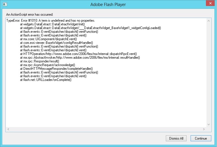
I problem, after compile, its widget error.
- Mark as New
- Bookmark
- Subscribe
- Mute
- Subscribe to RSS Feed
- Permalink
Ahmad,
Did you put the mx:DateFormatter in the <fx:Declarations> section?
When you debug what does the error window say?
- Mark as New
- Bookmark
- Subscribe
- Mute
- Subscribe to RSS Feed
- Permalink
Mr. Robert,
Yes, i put mx:DateFormatter in the <fx:Declarations>...
but i do not get error messages when compiling.
<?xml version="1.0" encoding="utf-8"?>
<viewer:BaseWidget xmlns:fx="http://ns.adobe.com/mxml/2009"
xmlns:s="library://ns.adobe.com/flex/spark"
xmlns:mx="library://ns.adobe.com/flex/mx"
xmlns:viewer="com.esri.viewer.*"
xmlns:esri="http://www.esri.com/2008/ags"
widgetConfigLoaded="init()">
<fx:Script>
<![CDATA[
import com.esri.ags.FeatureSet;
import com.esri.ags.Graphic;
import com.esri.ags.events.DrawEvent;
import com.esri.ags.events.GeometryServiceEvent;
import com.esri.ags.events.GeoprocessorEvent;
import com.esri.ags.geometry.Extent;
import com.esri.ags.geometry.Geometry;
import com.esri.ags.geometry.MapPoint;
import com.esri.ags.geometry.Polygon;
import com.esri.ags.layers.GraphicsLayer;
import com.esri.ags.symbols.Symbol;
import com.esri.ags.tasks.GeometryServiceSingleton;
import com.esri.ags.tasks.supportClasses.GPMessage;
import com.esri.ags.tasks.supportClasses.JobInfo;
import com.esri.ags.tools.DrawTool;
import com.esri.ags.tools.NavigationTool;
import com.esri.ags.utils.GeometryUtil;
import com.esri.ags.utils.GraphicUtil;
import com.esri.viewer.AppEvent;
import com.esri.viewer.ViewerContainer;
import com.esri.viewer.utils.ErrorMessageUtil;
import com.esri.viewer.utils.GenericJSONTask;
import mx.collections.ArrayCollection;
import mx.controls.Alert;
import mx.events.CloseEvent;
import mx.rpc.AsyncResponder;
import mx.rpc.Fault;
import mx.rpc.events.FaultEvent;
private var dataUrl:String = "";
private var file:FileReference;
private var outputFileName:String;
private var finishDrawing:Boolean;
private var graphicsLayer:GraphicsLayer;
private var graphicContextMenu:ContextMenu;
private var gpService:GenericJSONTask;
private var selectedDrawingIcon:Image;
private var drawSymbol:Symbol;
[Bindable]
private var exposeLayers:Boolean = true; //later set to FALSE!!
private var formatChoiceList:ArrayCollection;
private var rasterFormatChoiceList:ArrayCollection;
[Bindable]
private var rasterFormatChoiceListVisible:Boolean;
private var spatialReferenceChoiceList:ArrayCollection;
[Bindable]
private var spatialReferenceChoiceListVisible:Boolean;
[Bindable]
private var gpURL:String;
[Bindable]
private var layers:ArrayCollection;
private var excludeLayers:Array = [];
[Bindable]
private var useCurrentExtentAsAIO:Boolean = false;
private var useProxy:Boolean;
//labels
[Bindable]
private var descLabel:String;
[Bindable]
private var step1Label:String;
[Bindable]
private var polygonLabel:String;
[Bindable]
private var freehandPolygonLabel:String;
[Bindable]
private var rectangleLabel:String;
[Bindable]
private var circleLabel:String;
[Bindable]
private var ellipseLabel:String;
[Bindable]
private var clearLabel:String;
[Bindable]
private var dataCurrentExtentLabel:String;
[Bindable]
private var step2Label:String;
[Bindable]
private var step3Label:String;
[Bindable]
private var step4Label:String;
[Bindable]
private var step5Label:String;
[Bindable]
private var extractButtonLabel:String;
private var step1ErrorLabel:String;
private var step2ErrorLabel:String;
private var emptyResultsLabel:String;
private var saveDataFileLabel:String;
private function init():void
{
graphicsLayer = new GraphicsLayer();
map.addLayer(graphicsLayer);
if (configXML)
{
if (GeometryServiceSingleton.instance.url) // using GeometryServiceSingleton
{
geometryService.url = GeometryServiceSingleton.instance.url;
geometryService.token = GeometryServiceSingleton.instance.token;
geometryService.proxyURL = GeometryServiceSingleton.instance.proxyURL;
}
// TODO: check for non-existance
gpURL = String(configXML.dataextractionservice);
if (String(configXML.aioselectionmethod) == "extent")
{
useCurrentExtentAsAIO = true;
}
else
{
useCurrentExtentAsAIO = false;
}
//useproxy
if (configXML.useproxy.length() > 0)
{
useProxy = configXML.useproxy == "true";
}
gpService = new GenericJSONTask();
gpService.url = gpURL;
if (useProxy && configData.proxyUrl)
{
gpService.proxyURL = configData.proxyUrl;
gp.proxyURL = configData.proxyUrl;
}
var urlVars:URLVariables = new URLVariables();
urlVars.f = "json";
//Call gpService to get service properties
gpService.execute(urlVars, new AsyncResponder(gpService_resultHandler, gpService_faultHandler));
// exclude these layers
var excludeLayersXML:XMLList = configXML.excludelayer as XMLList;
for (var i:int = 0; i < excludeLayersXML.length(); i++)
{
excludeLayers.push(excludeLayersXML.toString());
}
outputFileName = (configXML.outputfilename[0] || formatDate.format(new Date)) + formatDDL.selectedItem.data.substring(formatDDL.selectedItem.data.lastIndexOf(".") + 1, formatDDL.selectedItem.data.length) + ".zip";
outputFileName = outputFileName.replace(/(\\|\/|:|\?|"|<|>|\|)/g, ""); //strip illegal characters
graphicsLayer.name = configXML.layername || widgetTitle;
//labels
descLabel = configXML.labels.desclabel[0] || getDefaultString("descLabel");
step1Label = configXML.labels.step1label[0] || getDefaultString("step1Label");
polygonLabel = configXML.labels.polygonlabel[0] || getDefaultString("drawPolygonLabel");
freehandPolygonLabel = configXML.labels.freehandpolygonlabel[0] || getDefaultString("drawFreehandPolygonLabel");
rectangleLabel = configXML.labels.rectanglelabel[0] || getDefaultString("drawRectangleLabel");
circleLabel = configXML.labels.circlelabel[0] || getDefaultString("drawCircleLabel");
ellipseLabel = configXML.labels.ellipselabel[0] || getDefaultString("drawEllipseLabel");
clearLabel = configXML.labels.clearlabel[0] || getDefaultString("clearLabel");
dataCurrentExtentLabel = configXML.labels.datacurrentextentlabel[0] || getDefaultString("dataCurrentExtentLabel");
step2Label = configXML.labels.step2label[0] || getDefaultString("step2Label");
step3Label = configXML.labels.step3label[0] || getDefaultString("step3Label");
step4Label = configXML.labels.step4label[0] || getDefaultString("step4Label");
step5Label = configXML.labels.step5label[0] || getDefaultString("step5Label");
extractButtonLabel = configXML.labels.extractbuttonlabel[0] || getDefaultString("extractButtonLabel");
step1ErrorLabel = configXML.labels.step1errorlabel[0] || getDefaultString("step1ErrorLabel");
step2ErrorLabel = configXML.labels.step2errorlabel[0] || getDefaultString("step2ErrorLabel");
emptyResultsLabel = configXML.labels.emptyresultslabel[0] || getDefaultString("emptyResultsLabel");
saveDataFileLabel = configXML.labels.savedatafilelabel[0] || getDefaultString("saveDataFileLabel");
initGraphicContextMenu();
}
AppEvent.addListener(AppEvent.DATA_PUBLISH, viewerContainer_dataPublishHandler);
}
private function initGraphicContextMenu():void
{
graphicContextMenu = new ContextMenu();
graphicContextMenu.hideBuiltInItems();
var menuItem:ContextMenuItem = new ContextMenuItem(clearLabel);
menuItem.addEventListener(ContextMenuEvent.MENU_ITEM_SELECT, menuItem_contextMenuDeleteHandler);
graphicContextMenu.customItems.push(menuItem);
}
protected function menuItem_contextMenuDeleteHandler(event:ContextMenuEvent):void
{
var graphic:Graphic = event.contextMenuOwner as Graphic;
var graphicsLayer:GraphicsLayer = graphic.graphicsLayer;
graphicsLayer.remove(graphic);
}
private function makeHTMLSafe(content:String):String
{
content = content.replace(/>/g, ">");
content = content.replace(/</g, "<");
return content;
}
private function callGPService():void
{
var geometries:Array = getInputGeometries();
if (geometries)
{
if (needToSimplifyPolygons(geometries))
{
geometryService.simplify(geometries);
}
else
{
createGPParamsAndExtract(geometries);
}
}
else
{
showError(step1ErrorLabel);
}
}
private function getInputGeometries():Array
{
var geometries:Array;
if (useCurrentExtentAsAIO)
{
geometries = [ getMapExtentEnvelope()];
}
else if (graphicsLayer.numGraphics > 0)
{
var graphics:Array = (graphicsLayer.graphicProvider as ArrayCollection).toArray();
geometries = GraphicUtil.getGeometries(graphics);
}
return geometries;
}
private function createGPParamsAndExtract(geometries:Array):void
{
var clipFS:FeatureSet = createClipFeatureSet(geometries);
if (clipFS)
{
var params:Object;
params = createGPParams(clipFS);
if (params)
{
setMapNavigation(null, null);
swfMessage.visible = true;
gp.processSpatialReference = map.spatialReference;
gp.outSpatialReference = map.spatialReference;
gp.submitJob(params);
}
}
}
private function needToSimplifyPolygons(geometries:Array):Boolean
{
var hasSelfIntersectingPolygons:Boolean = false;
for each (var geometry:Geometry in geometries)
{
if (geometry.type == Geometry.POLYGON)
{
if (GeometryUtil.polygonSelfIntersecting(geometry as Polygon))
{
hasSelfIntersectingPolygons = true;
break;
}
}
}
return hasSelfIntersectingPolygons;
}
private function createGPParams(clipFS:FeatureSet):Object
{
var gpParams:Object;
if (exposeLayers)
{
var layersToClip:Array = [];
for (var i:int = 0; i < layers.length; i++)
{
if (layers.getItemAt(i).selected)
{
layersToClip.push(layers.getItemAt(i).label);
}
}
if (layersToClip.length > 0)
{
gpParams =
{
"Area_of_Interest": clipFS,
"Feature_Format": formatDDL.selectedItem.data,
"Layers_to_Clip": layersToClip
};
// add if necessary
if (rasterFormatDDL.visible)
{
gpParams["Raster_Format"] = rasterFormatDDL.selectedItem.data;
}
if (spatialReferenceDDL.visible)
{
gpParams["Spatial_Reference"] = spatialReferenceDDL.selectedItem.data;
}
}
else
{
showError(step2ErrorLabel);
}
}
else
{
gpParams =
{
"Area_of_Interest": clipFS,
"Feature_Format": formatDDL.selectedItem.data
};
// add if necessary
if (rasterFormatChoiceListVisible)
{
gpParams["Raster_Format"] = rasterFormatDDL.selectedItem.data;
}
if (spatialReferenceChoiceListVisible)
{
gpParams["Spatial_Reference"] = spatialReferenceDDL.selectedItem.data;
}
}
return gpParams;
}
private function createClipFeatureSet(geometries:Array):FeatureSet
{
var clipFS:FeatureSet;
var features:Array = [];
for each (var geometry:Geometry in geometries)
{
features.push({ geometry: geometry });
}
clipFS = new FeatureSet();
clipFS.spatialReference = map.spatialReference;
clipFS.features = features;
return clipFS;
}
private function getMapExtentEnvelope():Polygon
{
//create the extent as a polygon
var mapExtentEnvelope:Polygon = new Polygon(null, map.spatialReference);
mapExtentEnvelope.rings =
[[
new MapPoint(map.extent.xmin, map.extent.ymin),
new MapPoint(map.extent.xmax, map.extent.ymin),
new MapPoint(map.extent.xmax, map.extent.ymax),
new MapPoint(map.extent.xmin, map.extent.ymax),
new MapPoint(map.extent.xmin, map.extent.ymin)
]];
return mapExtentEnvelope;
}
//
// Draw functions
//
private function activateDrawTool(event:MouseEvent):void
{
addSharedData("Deactivate_DrawTool", null); // to be able to deactivate drawTool on other widgets
// apply glow
selectedDrawingIcon = Image(event.currentTarget);
clearSelectionFilter();
selectedDrawingIcon.filters = [ glowFilter ];
finishDrawing = false;
dataUrl = "";
var status:String;
var value:String = selectedDrawingIcon.name;
switch (value)
{
case DrawTool.POLYGON:
{
status = polygonLabel;
break;
}
case DrawTool.FREEHAND_POLYGON:
{
status = freehandPolygonLabel;
break;
}
case DrawTool.EXTENT:
{
status = rectangleLabel;
break;
}
case DrawTool.CIRCLE:
{
status = circleLabel;
break;
}
case DrawTool.ELLIPSE:
{
status = ellipseLabel;
break;
}
}
drawSymbol = new SimpleFillSymbol(SimpleFillSymbol.STYLE_SOLID, 0x3FAFDC, 0.5, new SimpleLineSymbol(SimpleLineSymbol.STYLE_SOLID, 0x3FAFDC, 1, 2));
setMapAction(value, status, drawSymbol, map_drawEndHandler);
}
private function clearSelectionFilter():void
{
for (var i:int = 0; i < aioBox.numChildren; i++)
{
if (aioBox.getChildAt(i).filters && aioBox.getChildAt(i).filters.length > 0)
{
if (!(selectedDrawingIcon && aioBox.getChildAt(i) === selectedDrawingIcon))
{
aioBox.getChildAt(i).filters = [];
}
}
}
}
private function onTurnOnNav():void
{
setMapNavigation(NavigationTool.PAN, "Pan Map");
}
private function clear():void
{
onTurnOnNav();
graphicsLayer.clear();
}
private function viewerContainer_dataPublishHandler(event:AppEvent):void
{
var data:Object = event.data;
if (data.key == "Deactivate_DrawTool")
{
setMapAction(null, null, null, null);
if (selectedDrawingIcon)
{
selectedDrawingIcon.filters = [];
selectedDrawingIcon = null;
}
}
}
private function wTemplate_closedHandler(event:Event):void
{
graphicsLayer.visible = false;
setMapAction(null, null, null, null); // deactivate drawTool
if (selectedDrawingIcon)
{
selectedDrawingIcon.filters = [];
selectedDrawingIcon = null;
}
}
private function wTemplate_openHandler(event:Event):void
{
if (graphicsLayer)
{
graphicsLayer.visible = true;
}
}
private function wTemplate_minimizedHandler(event:Event):void
{
graphicsLayer.visible = false;
}
private function icon_rollOverHandler(event:MouseEvent):void
{
clearSelectionFilter();
event.target.filters = [ glowFilter ];
}
private function icon_rollOutHandler(event:MouseEvent):void
{
clearSelectionFilter();
}
private function map_drawEndHandler(event:DrawEvent):void
{
// deactivate the draw tool
finishDrawing = true;
selectedDrawingIcon = null;
clearSelectionFilter();
onTurnOnNav();
var graphic:Graphic = event.graphic;
graphic.contextMenu = graphicContextMenu;
if (graphic.geometry is Extent)
{
// convert extent to a polygon
const extent:Extent = Extent(graphic.geometry);
var extentPolygon:Polygon = new Polygon(null, map.spatialReference);
extentPolygon.rings = [[
new MapPoint(extent.xmin, extent.ymin),
new MapPoint(extent.xmax, extent.ymin),
new MapPoint(extent.xmax, extent.ymax),
new MapPoint(extent.xmin, extent.ymax),
new MapPoint(extent.xmin, extent.ymin)
]];
graphic.geometry = extentPolygon;
}
graphic.symbol = drawSymbol;
// add graphic to the graphics layer
graphicsLayer.add(graphic);
}
private function gp_jobCompleteHandler(event:GeoprocessorEvent):void
{
swfMessage.visible = false;
if (event.jobInfo.jobStatus == JobInfo.STATUS_SUCCEEDED)
{
gp.getResultData(gp.submitJobLastResult.jobId,
"Output_Zip_File"); // parameterName
}
else
{
var msg:String = getDefaultString("problemLabel") + "\n\n\n" + event.jobInfo.jobStatus;
if (event.jobInfo.messages)
{
msg += "\n\n\n" + GPMessage(event.jobInfo.messages[event.jobInfo.messages.length - 1]).description;
}
showError(msg);
}
}
private function gp_getResultDataCompleteHandler(event:GeoprocessorEvent):void
{
if (event.parameterValue)
{
dataUrl = String(event.parameterValue.value.url);
if (!dataUrl)
{
showError(emptyResultsLabel);
return;
}
Alert.show(saveDataFileLabel, wTemplate.widgetTitle, Alert.YES | Alert.NO, null, alert_ClickHandler);
}
else
{
showError(emptyResultsLabel);
}
}
// Event handler function for displaying the selected Alert button.
private function alert_ClickHandler(event:CloseEvent):void
{
if (event.detail == Alert.YES)
{
downloadFile(dataUrl);
}
}
private function downloadFile(url:String):void
{
var downloadURL:URLRequest = new URLRequest();
downloadURL.url = url;
file = new FileReference();
// TODO: can we be smarter with the name of the zip file? For example, for single layers, using a modified layer name?
file.download(downloadURL, outputFileName);
}
private function gp_faultHandler(event:FaultEvent):void
{
swfMessage.visible = false;
var msg:String = getDefaultString("problemLabel") + "\n\n\n" + event.fault.faultString;
showError(msg);
}
private function gpService_resultHandler(serviceProperties:Object, token:Object = null):void
{
var params:Array = serviceProperties.parameters;
rasterFormatChoiceListVisible = false;
spatialReferenceChoiceListVisible = false;
for (var i:int = 0; i < params.length; i++)
{
if (params.name == "Layers_to_Clip")
{
layers = new ArrayCollection();
exposeLayers = true;
for each (var layer:Object in params.choiceList)
{
if (excludeLayers.indexOf(layer) == -1)
{
var obj:Object = { label: layer, selected: false };
layers.addItem(obj);
}
}
}
if (params.name == "Feature_Format")
{
formatChoiceList = new ArrayCollection();
for each (var format:String in params.choiceList)
{
const fileLabel:String = format.substring(0, format.indexOf("-") - 1);
const fileExtension:String = format.substring(format.lastIndexOf("."), format.length);
formatChoiceList.addItem({ data: format, label: fileLabel + " (" + fileExtension + ")" });
}
}
if (params.name == "Raster_Format")
{
rasterFormatChoiceListVisible = true;
rasterFormatChoiceList = new ArrayCollection();
for each (var rasterFormat:String in params.choiceList)
{
const fileLabel1:String = rasterFormat.substring(0, rasterFormat.indexOf("-") - 1);
const fileExtension1:String = rasterFormat.substring(rasterFormat.lastIndexOf("."), rasterFormat.length);
rasterFormatChoiceList.addItem({ data: rasterFormat, label: fileLabel1 + " (" + fileExtension1 + ")" });
}
}
if (params.name == "Spatial_Reference")
{
spatialReferenceChoiceListVisible = true;
spatialReferenceChoiceList = new ArrayCollection();
for each (var spatialReferenceString:String in params.choiceList)
{
spatialReferenceChoiceList.addItem({ data: spatialReferenceString, label: spatialReferenceString });
}
}
}
checkBoxDG.dataProvider = layers;
formatDDL.dataProvider = formatChoiceList;
rasterFormatDDL.dataProvider = rasterFormatChoiceList;
spatialReferenceDDL.dataProvider = spatialReferenceChoiceList;
}
private function gpService_faultHandler(fault:Fault, token:Object = null):void
{
var msg:String = "Unable to connect to GP Service:\n"
+ gp.url + "\n\n"
+ "Most likely cause:\n"
+ ErrorMessageUtil.getKnownErrorCauseMessage(fault.faultCode) + "\n\n"
+ "Details:\n"
+ makeHTMLSafe(fault.toString());
showError(msg);
widgetVBox.enabled = false;
}
private function geometryService_faultHandler(event:FaultEvent):void
{
showError(event.fault.toString());
}
private function geometryService_simplifyHandler(event:GeometryServiceEvent):void
{
createGPParamsAndExtract(event.result as Array);
}
]]>
</fx:Script>
<fx:Declarations>
<esri:SimpleFillSymbol id="sfs"
alpha="0.8"
color="#FFFFFF">
<esri:SimpleLineSymbol width="2"
color="#00FF00"
style="solid"/>
</esri:SimpleFillSymbol>
<mx:DateFormatter id="formatDate" formatString="YYYY-MMM-DD-HHNNSS"/>
<esri:GeometryService id="geometryService"
fault="geometryService_faultHandler(event)"
simplifyComplete="geometryService_simplifyHandler(event)"
url="http://tasks.arcgisonline.com/ArcGIS/rest/services/Geometry/GeometryServer"/>
<!-- GP -->
<esri:Geoprocessor id="gp"
concurrency="last"
fault="gp_faultHandler(event)"
getResultDataComplete="gp_getResultDataCompleteHandler(event)"
jobComplete="gp_jobCompleteHandler(event)"
url="{gpURL}"/>
<!-- Effects and Filters-->
<s:GlowFilter id="glowFilter"
alpha="1"
color="{getStyle('focusColor')}"
inner="true"
strength="2"/>
</fx:Declarations>
<viewer:WidgetTemplate id="wTemplate"
width="320" height="300"
closed="wTemplate_closedHandler(event)"
minHeight="300"
minWidth="320"
minimized="wTemplate_minimizedHandler(event)"
open="wTemplate_openHandler(event)">
<s:Scroller width="100%" height="100%"
horizontalScrollPolicy="off">
<s:VGroup id="widgetVBox"
width="100%" height="100%"
gap="4"
verticalAlign="middle">
<s:Label width="100%" text="{descLabel}"/>
<mx:Spacer/>
<s:HGroup id="aioBox"
width="100%" height="40"
gap="0"
horizontalAlign="left"
includeInLayout="{!useCurrentExtentAsAIO}"
visible="{!useCurrentExtentAsAIO}">
<s:VGroup height="100%">
<s:Label text="{step1Label}"/>
<mx:Spacer height="100%"/>
<s:HGroup width="100%" height="100%"
horizontalAlign="right"
paddingBottom="3">
<s:Label click="clear()"
text="{clearLabel}"
textDecoration="underline"
buttonMode="true"
useHandCursor="true"/>
</s:HGroup>
</s:VGroup>
<mx:Image name="{DrawTool.EXTENT}"
width="40" height="40"
buttonMode="true"
click="activateDrawTool(event)"
rollOut="icon_rollOutHandler(event)"
rollOver="icon_rollOverHandler(event)"
source="assets/images/i_draw_rect.png"
toolTip="{rectangleLabel}"
useHandCursor="true"/>
<mx:Image name="{DrawTool.CIRCLE}"
width="40" height="40"
buttonMode="true"
click="activateDrawTool(event)"
rollOut="icon_rollOutHandler(event)"
rollOver="icon_rollOverHandler(event)"
source="assets/images/i_draw_circle.png"
toolTip="{circleLabel}"
useHandCursor="true"/>
<mx:Image name="{DrawTool.ELLIPSE}"
width="40" height="40"
buttonMode="true"
click="activateDrawTool(event)"
rollOut="icon_rollOutHandler(event)"
rollOver="icon_rollOverHandler(event)"
source="assets/images/i_draw_ellipse.png"
toolTip="{ellipseLabel}"
useHandCursor="true"/>
<mx:Image name="{DrawTool.POLYGON}"
width="40" height="40"
buttonMode="true"
click="activateDrawTool(event)"
rollOut="icon_rollOutHandler(event)"
rollOver="icon_rollOverHandler(event)"
source="assets/images/i_draw_poly.png"
toolTip="{polygonLabel}"
useHandCursor="true"/>
<mx:Image name="{DrawTool.FREEHAND_POLYGON}"
width="40" height="40"
buttonMode="true"
click="activateDrawTool(event)"
rollOut="icon_rollOutHandler(event)"
rollOver="icon_rollOverHandler(event)"
source="assets/images/i_draw_freepoly.png"
toolTip="{freehandPolygonLabel}"
useHandCursor="true"/>
</s:HGroup>
<s:Label width="100%"
includeInLayout="{useCurrentExtentAsAIO}"
text="{dataCurrentExtentLabel}"
visible="{useCurrentExtentAsAIO}"/>
<s:Line width="100%">
<s:stroke>
<s:SolidColorStroke color="0xEEEEEE" weight="2"/>
</s:stroke>
</s:Line>
<s:VGroup width="{wTemplate.width - 40}" height="{widgetVBox.height - aioBox.height - 110}"
gap="4"
includeInLayout="{exposeLayers}"
visible="{exposeLayers}">
<s:Label paddingTop="4" text="{step2Label}"/>
<s:Scroller width="100%" height="100%">
<s:DataGroup id="checkBoxDG" dataProvider="{layers}">
<s:layout>
<s:VerticalLayout gap="2"
horizontalAlign="left"
useVirtualLayout="true"/>
</s:layout>
<s:itemRenderer>
<fx:Component>
<s:DataRenderer>
<s:CheckBox label="{data.label}" selected="@{data.selected}">
</s:CheckBox>
</s:DataRenderer>
</fx:Component>
</s:itemRenderer>
</s:DataGroup>
</s:Scroller>
</s:VGroup>
<s:Line width="100%"
includeInLayout="{exposeLayers}"
visible="{exposeLayers}">
<s:stroke>
<s:SolidColorStroke color="0xEEEEEE" weight="2"/>
</s:stroke>
</s:Line>
<s:VGroup width="100%" height="100%">
<s:Label paddingTop="4" text="{step3Label}"/>
<s:DropDownList id="formatDDL"
width="100%"
requireSelection="true"/>
<s:Label includeInLayout="{rasterFormatChoiceListVisible}"
paddingTop="4"
text="{step4Label}"
visible="{rasterFormatChoiceListVisible}"/>
<s:DropDownList id="rasterFormatDDL"
width="100%"
includeInLayout="{rasterFormatChoiceListVisible}"
requireSelection="true"
visible="{rasterFormatChoiceListVisible}"/>
<s:Label includeInLayout="{spatialReferenceChoiceListVisible}"
paddingTop="4"
text="{step5Label}"
visible="{spatialReferenceChoiceListVisible}"/>
<s:DropDownList id="spatialReferenceDDL"
width="100%"
includeInLayout="{spatialReferenceChoiceListVisible}"
requireSelection="true"
visible="{spatialReferenceChoiceListVisible}"/>
<s:HGroup width="100%" verticalAlign="middle">
<s:Button id="extract"
click="callGPService()"
horizontalCenter="0"
label="{extractButtonLabel}"/>
<mx:Image id="swfMessage"
source="assets/images/loader.swf"
visible="false"/>
</s:HGroup>
</s:VGroup>
</s:VGroup>
</s:Scroller>
</viewer:WidgetTemplate>
</viewer:BaseWidget>
when I use mozilla display an error message
- Mark as New
- Bookmark
- Subscribe
- Mute
- Subscribe to RSS Feed
- Permalink
line 663 you have the date format wrong.... you have HHNNSS for time... shouldn't that be HHMMSS
M not N
- Mark as New
- Bookmark
- Subscribe
- Mute
- Subscribe to RSS Feed
- Permalink
Thanks Mr. Patterson has responded,
but I also have problems to add the file extension in the name of the downloaded.
outputFileName = (configXML.outputfilename[0] || formatDate.format(new Date)) + formatDDL.selectedItem.data.substring(formatDDL.selectedItem.data.lastIndexOf(".") + 1, formatDDL.selectedItem.data.length) + ".zip";- Mark as New
- Bookmark
- Subscribe
- Mute
- Subscribe to RSS Feed
- Permalink
that was just one error I found skimming the document... I suggest you go through it slowly and check to see if there are any other errors or go back to the stage where it worked then sequentially add more 'bits' until it fails. It appears that you did a whole load of things all at once and the error is buried in the sequence of your activities. Incrementally build and test before you move forward is prudent
And on that note what is outFilename supposed to look like? Why don't you hard code it for now ie c:\temp\test.zip to see if everything works up to that point. If it doesn't, the error lies in the concatenation of the filename or one of the elements therein. Does this java(?) stuff not have the ability to print? I will let you read through it to see if the parts of the concatenation are correct and provide a sample of what the output filename is supposed to look like... perhaps you shouldn't use a ".zip" extension but "zip" without the period... maybe you have 2 periods in the output.