Turn on suggestions
Auto-suggest helps you quickly narrow down your search results by suggesting possible matches as you type.
Cancel
- Home
- :
- All Communities
- :
- Developers
- :
- ArcGIS API for Flex (Retired)
- :
- ArcGIS API for Flex Questions
- :
- Re: Could not resolve <s:controlBarContent> to a c...
Options
- Subscribe to RSS Feed
- Mark Topic as New
- Mark Topic as Read
- Float this Topic for Current User
- Bookmark
- Subscribe
- Mute
- Printer Friendly Page
Could not resolve <s:controlBarContent> to a component implementation ...Urgent Help
Subscribe
4130
8
06-01-2011 07:58 AM
by
Anonymous User
Not applicable
06-01-2011
07:58 AM
- Mark as New
- Bookmark
- Subscribe
- Mute
- Subscribe to RSS Feed
- Permalink
Original User: sravabonagiri
Hi Flex Gurus,
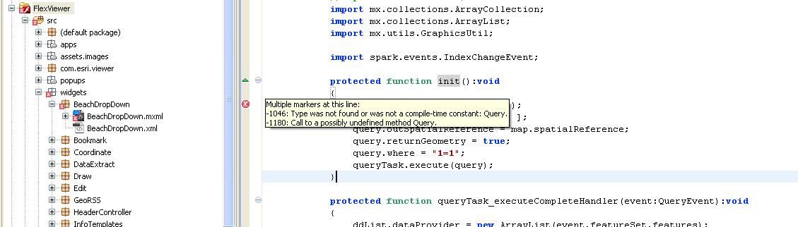
I need a small favor. I am working on a dropdown control and zoom to feature (point) for a beach application. I was able to implement the attached code alright for a standalone application. But, When I am adding the code as a custom widget to my existing code....I am getting the following error. That is, Could not resolve <s:controlBarContent> to a component implementation. I attached the code as well as error image here. Could you please help me fix the issue. Please let me know if you need further information. Many thanks for your help.
Thanks,
Sam
Hi Flex Gurus,
I need a small favor. I am working on a dropdown control and zoom to feature (point) for a beach application. I was able to implement the attached code alright for a standalone application. But, When I am adding the code as a custom widget to my existing code....I am getting the following error. That is, Could not resolve <s:controlBarContent> to a component implementation. I attached the code as well as error image here. Could you please help me fix the issue. Please let me know if you need further information. Many thanks for your help.
Thanks,
Sam
8 Replies
by
Anonymous User
Not applicable
06-01-2011
08:26 AM
- Mark as New
- Bookmark
- Subscribe
- Mute
- Subscribe to RSS Feed
- Permalink
Original User: rscheitlin
Sam,
Here is what you have so far fixed:
Sam,
Here is what you have so far fixed:
<?xml version="1.0" encoding="utf-8"?>
<!--
////////////////////////////////////////////////////////////////////////////////
//
// Copyright (c) 2010 ESRI
//
// All rights reserved under the copyright laws of the United States.
// You may freely redistribute and use this software, with or
// without modification, provided you include the original copyright
// and use restrictions.  See use restrictions in the file:
// <install location>/License.txt
//
////////////////////////////////////////////////////////////////////////////////
-->
<viewer:BaseWidget xmlns:fx="http://ns.adobe.com/mxml/2009"
       xmlns:s="library://ns.adobe.com/flex/spark"
       xmlns:mx="library://ns.adobe.com/flex/mx"
       xmlns:esri="http://www.esri.com/2008/ags"
       xmlns:custom="components.*"
       xmlns:viewer="com.esri.viewer.*"
       widgetConfigLoaded="init()">

 <fx:Declarations>
  <esri:QueryTask id="queryTask"
      executeComplete="queryTask_executeCompleteHandler(event)"
      showBusyCursor="true"
      url="http://167.193.56.180/ArcGIS/rest/services/Georgia_Beach/MapServer/0"
      useAMF="false"/>
 </fx:Declarations>

 <fx:Script>
  <![CDATA[
   import com.esri.ags.Graphic;
   import com.esri.ags.events.MapEvent;
   import com.esri.ags.events.QueryEvent;
   import com.esri.ags.geometry.Extent;
   import com.esri.ags.geometry.Geometry;
   import com.esri.ags.geometry.MapPoint;
   import com.esri.ags.tasks.supportClasses.Query;
   import com.esri.ags.utils.GraphicUtil;

   import mx.collections.ArrayCollection;
   import mx.collections.ArrayList;

   import spark.events.IndexChangeEvent;

   protected function init():void
   {
    var query:Query = new Query();
    query.outFields = [ "NAME_1" ];
    query.outSpatialReference = map.spatialReference;
    query.returnGeometry = true;
    query.where = "1=1";
    queryTask.execute(query);
   }

   protected function queryTask_executeCompleteHandler(event:QueryEvent):void
   {
    ddList.dataProvider = new ArrayList(event.featureSet.features);
   }

   protected function ddListLabelFunction(item:Graphic):String
   {
    return item.attributes["NAME_1"];
   }

   protected function ddList_changeHandler(event:IndexChangeEvent):void
   {
    var pt:MapPoint = MapPoint(Graphic(ddList.selectedItem).geometry);
    var beachExtent:Extent = new Extent(pt.x - 100, pt.y -100, pt.x + 100, pt.y + 100);
    map.extent = beachExtent

    // make sure the whole extent is visible
    if (!map.extent.contains(beachExtent))
    {
     map.level--;
    }
   }
  ]]>
 </fx:Script>

 <viewer:WidgetTemplate id="DropDown" width="300" height="200" >
  <viewer:layout>
   <s:HorizontalLayout horizontalAlign="center" verticalAlign="middle"/>
  </viewer:layout>
   <s:DropDownList id="ddList"
       width="200"
       change="ddList_changeHandler(event)"
       labelFunction="ddListLabelFunction"
       prompt="Choose a beach..."/>
 </viewer:WidgetTemplate>
</viewer:BaseWidget>
by
Anonymous User
Not applicable
06-01-2011
10:42 AM
- Mark as New
- Bookmark
- Subscribe
- Mute
- Subscribe to RSS Feed
- Permalink
Original User: rscheitlin
Sam,
What ESRI Flex API version are you using?
Sam,
What ESRI Flex API version are you using?
06-01-2011
11:18 AM
- Mark as New
- Bookmark
- Subscribe
- Mute
- Subscribe to RSS Feed
- Permalink
Robert,
I am using agslib-2.3.1-2011-04-26.
I am using agslib-2.3.1-2011-04-26.
by
Anonymous User
Not applicable
06-01-2011
11:23 AM
- Mark as New
- Bookmark
- Subscribe
- Mute
- Subscribe to RSS Feed
- Permalink
Original User: rscheitlin
Sam,
The issue I am having is that because the code already has:
There is no reason for that error if you are using agslib-2.3.1-2011-04-26...:confused:
Sam,
The issue I am having is that because the code already has:
import com.esri.ags.tasks.supportClasses.Query;
There is no reason for that error if you are using agslib-2.3.1-2011-04-26...:confused:
06-01-2011
11:37 AM
- Mark as New
- Bookmark
- Subscribe
- Mute
- Subscribe to RSS Feed
- Permalink
Ok. Thanks for your continued support. I am new to Flex development. Previously, I was working with Silverlight API. I hear some compatibility issues with Flash Builder 4.5. Should I go back to Flash Builder 4.0?
Thanks,
Sam
Thanks,
Sam
by
Anonymous User
Not applicable
06-01-2011
11:40 AM
- Mark as New
- Bookmark
- Subscribe
- Mute
- Subscribe to RSS Feed
- Permalink
Original User: rscheitlin
Sam,
No that is not the issue because I build the exact code I sent you using Flash Builder 4.5 and the 4.5 SDK as well. See what happens when you fully qualify the query in the init function.
Sam,
No that is not the issue because I build the exact code I sent you using Flash Builder 4.5 and the 4.5 SDK as well. See what happens when you fully qualify the query in the init function.
protected function init():void
   {
    var query:com.esri.ags.tasks.supportClasses.Query = new com.esri.ags.tasks.supportClasses.Query();
    query.outFields = [ "NAME_1" ];
    query.outSpatialReference = map.spatialReference;
    query.returnGeometry = true;
    query.where = "1=1";
    queryTask.execute(query);
   }
06-01-2011
11:47 AM
- Mark as New
- Bookmark
- Subscribe
- Mute
- Subscribe to RSS Feed
- Permalink
Excellent. It did the trick. Thanks for persisting with me. Thanks a ton.