- Home
- :
- All Communities
- :
- Products
- :
- 3D
- :
- 3D Questions
- :
- Re: Wrong altitudal range in DEM
- Subscribe to RSS Feed
- Mark Topic as New
- Mark Topic as Read
- Float this Topic for Current User
- Bookmark
- Subscribe
- Mute
- Printer Friendly Page
Wrong altitudal range in DEM
- Mark as New
- Bookmark
- Subscribe
- Mute
- Subscribe to RSS Feed
- Permalink
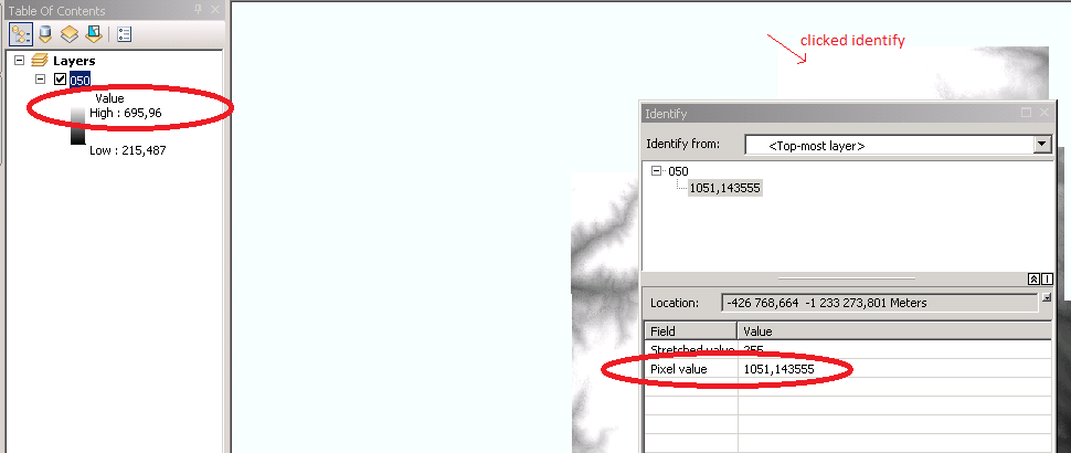
Hello friends,
i have DEM created from lidar data....
and when i clicked on white zone "identify" - pixel value is 1051,143555
BUT
range says that max value is only 695,96.
Is there any solution for this? Thank you so much.
- Mark as New
- Bookmark
- Subscribe
- Mute
- Subscribe to RSS Feed
- Permalink
it looks like you are using a stretched symbology perhaps and are the units supposed to be in feet or meters and I suspect you are using a comma as the decimal separator
- Mark as New
- Bookmark
- Subscribe
- Mute
- Subscribe to RSS Feed
- Permalink
yes i am using stretched symbology, but units are in meters.....i found this...........can i just overwrite that "679" with "1069,31"?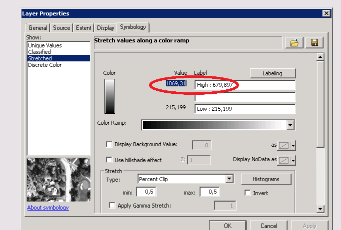
- Mark as New
- Bookmark
- Subscribe
- Mute
- Subscribe to RSS Feed
- Permalink
Hi SV,
It might be a comma because in Czech a comma is used instead of a decimal point. In your raw data is a comma or a decimal point? It might be ArcGIS set to your language that is causing the decimal comma to be shown instead of the decimal point.
Decimal mark - Wikipedia, the free encyclopedia
I know this does not help your original question, just trying to make sure that's not the issue.
Arthur Crawford
- Mark as New
- Bookmark
- Subscribe
- Mute
- Subscribe to RSS Feed
- Permalink
Hi, mr. Crawford,
I just found out that the problem is that in the range of altitudes (215-695) did not take into account the value where stretched value is 255 