Turn on suggestions
Auto-suggest helps you quickly narrow down your search results by suggesting possible matches as you type.
Cancel
- Home
- :
- All Communities
- :
- Products
- :
- 3D
- :
- 3D Questions
- :
- rectify image in 3D
Options
- Subscribe to RSS Feed
- Mark Topic as New
- Mark Topic as Read
- Float this Topic for Current User
- Bookmark
- Subscribe
- Mute
- Printer Friendly Page
rectify image in 3D
Subscribe
2657
4
02-17-2011 11:35 PM
02-17-2011
11:35 PM
- Mark as New
- Bookmark
- Subscribe
- Mute
- Subscribe to RSS Feed
- Permalink
Hi.
I have been working with geophysical data for over two years now and my dream has always been to be able to rectify images of seismic lines vertically. Until now I haven't found a way to do this, but few months ago I saw this http://blogs.esri.com/Dev/photos/desktop94/picture11167.aspx and now I am very excited to know how to do this, because this is exactly what my dream is about.
Can anyone please tell me how to do this.
Regards.
Steinthor Traustason
Geographer
Mannvit engeneering
Iceland
4 Replies
03-29-2011
07:39 AM
- Mark as New
- Bookmark
- Subscribe
- Mute
- Subscribe to RSS Feed
- Permalink
Hi Steinthor,
I hope it's not too late, but I was looking at exactly the same functionality to insert seismic lines and geological cross-sections. In fact, it's not that complicated, just a bit messy to play with.
The way I've found to insert vertical images is by defining a 3D marker symbol to a point. First off, you have to define an anchor point for your image you want to place vertically. Each vertical image you insert is a different shapefile. Otherwise each point will get the same image.
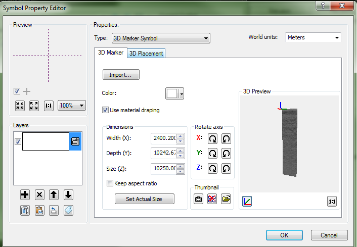
Once you have your anchor point, go in Edit Symbol and select 3D Marker Symbol. Import the image you wish to place (i recommend using rather low-res .png, otherwise it will be quite slow, especially with seismic surveys). Then edit the settings for the X Y Z and click Use Material Draping (see 3dmarker.png). Width (X) generally is the length of the line, while Z is your vertical depth (pretty useful to uncheck Keep Aspect Ratio if you wish to convert from time to meters).
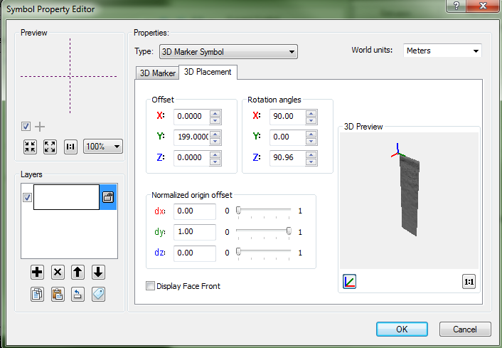
In the 3D Placement Tab, you can edit (3dmarker2.png) where the image will anchor and its orientation. You have to play a bit with all these options as there are several ways to obtain the same result. One thing's sure, you have to uncheck "Display Face Front".
Hope it helps.
Christian Beaulieu
VIASAT GeoTechnologies
Montréal
I hope it's not too late, but I was looking at exactly the same functionality to insert seismic lines and geological cross-sections. In fact, it's not that complicated, just a bit messy to play with.
The way I've found to insert vertical images is by defining a 3D marker symbol to a point. First off, you have to define an anchor point for your image you want to place vertically. Each vertical image you insert is a different shapefile. Otherwise each point will get the same image.
Once you have your anchor point, go in Edit Symbol and select 3D Marker Symbol. Import the image you wish to place (i recommend using rather low-res .png, otherwise it will be quite slow, especially with seismic surveys). Then edit the settings for the X Y Z and click Use Material Draping (see 3dmarker.png). Width (X) generally is the length of the line, while Z is your vertical depth (pretty useful to uncheck Keep Aspect Ratio if you wish to convert from time to meters).
In the 3D Placement Tab, you can edit (3dmarker2.png) where the image will anchor and its orientation. You have to play a bit with all these options as there are several ways to obtain the same result. One thing's sure, you have to uncheck "Display Face Front".
Hope it helps.
Christian Beaulieu
VIASAT GeoTechnologies
Montréal
03-31-2011
12:15 PM
- Mark as New
- Bookmark
- Subscribe
- Mute
- Subscribe to RSS Feed
- Permalink
...be able to rectify images of seismic lines vertically
This sort of work can be easily done in geological/mining software such as GEMS, Surpack by Gemcom. Not sure if Target for ArcGIS by Geosoft allows you to digitize vertically from a section but i suspect so. (Be prepared for an astronomical price tag, especially for Gemcom software.) GEMS also allows you to geo-reference and digitize on inclined sections.
I would love to have this functionality in ArcGIS and hoping someone will write an add-on for this soon. All the ingredients are there...
04-01-2011
05:44 AM
- Mark as New
- Bookmark
- Subscribe
- Mute
- Subscribe to RSS Feed
- Permalink
Can't agree more with you on this Jakub, editing in 3D with ArcScene is really painful. So little is missing to make it viable. Smoothing 3D polylines and a "polylines to surface tool" would also be very useful...
01-04-2012
06:05 AM
- Mark as New
- Bookmark
- Subscribe
- Mute
- Subscribe to RSS Feed
- Permalink
Hi Christian,
The way you've found is amazing. Just the way I've been looking for years. Done lot of work verry efficiently and fast.
Thanks..
inan
I hope it's not too late, but I was looking at exactly the same functionality to insert seismic lines and geological cross-sections. In fact, it's not that complicated, just a bit messy to play with......................
The way you've found is amazing. Just the way I've been looking for years. Done lot of work verry efficiently and fast.
Thanks..
inan
cbeaulieu29;89393 wrote:
Hi Steinthor,
I hope it's not too late, but I was looking at exactly the same functionality to insert seismic lines and geological cross-sections. In fact, it's not that complicated, just a bit messy to play with......................