- Home
- :
- All Communities
- :
- Products
- :
- 3D
- :
- 3D Mapping Questions
- :
- Coordinate Transforms Suitable for Cesium Tiles in...
- Subscribe to RSS Feed
- Mark Topic as New
- Mark Topic as Read
- Float this Topic for Current User
- Bookmark
- Subscribe
- Mute
- Printer Friendly Page
Coordinate Transforms Suitable for Cesium Tiles in Local Scene
- Mark as New
- Bookmark
- Subscribe
- Mute
- Subscribe to RSS Feed
- Permalink
Background:
Cesium Tiles (and by extension 3TZ) is now supported in ArcGIS Pro. The format is, as specified in the documents lodged with the OGC, inherently in a Cartesian geocentric coordinate reference system that may be, but is not limited to WGS84 Ensemble (4978), any of the six specific realisations of WGS84, or GDA2020 (7842). Cesium Tiles v1.0 does not support any sort of CRS definition tag in the header, and whilst Cesium Tiles v1.1 does, nothing ever seems to actually utilise it, so for all intents and purposes Cesium Tiles can be considered as lacking a CRS definition in its headers.
In Australia, we've been using this format defined in that last one: GDA2020 Cartesian geocentric. All our other formats (GDB, etc) are in local projected coordinates (typically GDA2020 MGA5X, AHD). The different formats are ultimately used in different software packages (ArcGIS Pro, Terria, etc) by different users hence us supporting such different coordinate reference systems. Our workflows involve QA checks on these formats both to other datasets and against one another.
Unfortunately a lot of software, ArcGIS Pro included, mistakenly assumes all Cesium Tiles datasets are in WGS84 rather than simply asking which Cartesian system it uses, which causes no end of UI issues.
Question:
I cannot get Cesium Tiles to display without issue in a local scene in ArcGIS Pro.
- Cesium Tiles layers are read in (erroneously) as "WGS84/WGS84" as the horizontal/vertical CRS pair.
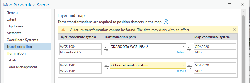
- Under the Transformations tab of the Map Properties: Scene dialog box, ArcGIS displays a warning stating "A datum transformation cannot be found. The data may draw with an offset." See screenshot below (the relevant row is the second one). Unfortunately, the dropdown box of available transformation pathways remains empty. I'm seeing an offset for sure, but it is difficult to tell if this is a dataset error or a software error.
How can I go about confidently setting this transform pathway? All the pieces seem to be defined somewhere within ArcGIS's Projection Engine but ArcGIS seems reluctant to let me use them.
Ultimately, the pathway required is GDA2020 Cartesian Geocentric (7842/7842) -> GDA2020 MGA5X AHD (785X/5711). And it needs to be set in such a way that I can apply it to these layers erroneously considered to be in WGS84 Ensemble Cartesian Geocentric. I've tried messing about with the Create Custom Transformations tools, but to little avail.
Edit: It might not be the pathway stated above. When I look at the layer properties, ArcGIS Pro seems to interpret them as 4326/115700 which I know is impossible as geographic coordinates are not supported by the file format itself. It is unclear whether this is a display error or the first part of the transformation is automatic, changing the starting point of the required transformation.
Thanks in advance.