Select to view content in your preferred language

Flood Impact Analysis solution

17533
31
02-06-2019 03:01 PM
Gert_van_Maren
Esri Contributor
14 31 17.5K

What is the Flood Impact Analysis solution?

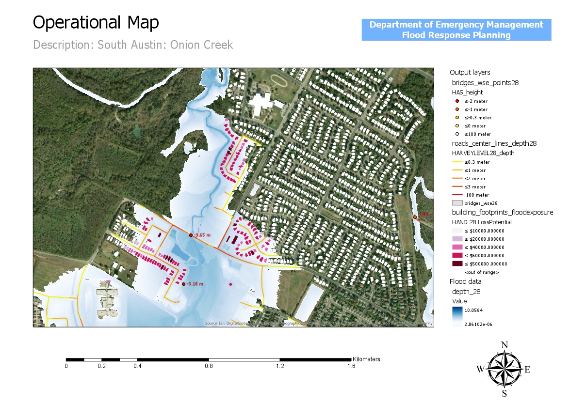
The Flood Impact Analysis solution can be used to develop flooding scenarios and visualize the impact on the existing landscape. It leverages flood depth data to analyze the impact of flood events on critical assets such as buildings, bridges, low water crossings and roads.  It also can be used to create compelling 3D visualizations that make it easier to understand and communicate the real impact of flooding events.
Benefits

The flood impact analysis solution template leverages flood depth data to analyze the impact of flood events on critical assets such as buildings, bridges, low water crossings and roads. You can: 

  • Define flood impact areas at each flood stage
  • Determine what assets will be impacted and by how much
  • Communicate the results of the analysis to community stakeholders
  • create compelling 3D visualizations that make it easier to understand and communicate the real impact of flooding events. 

Example: Operations Dashboard for ArcGIS 

Get started with the Flood Impact Analysis solution

  1. Deploy the Flood Impact Analysis Pro project.
  2. Open the FloodImpactAnalysis.aprx in ArcGIS Pro

System requirements

The following software is required:

  • ArcGIS Pro 2.4 or higher (Advanced)
  • ArcGIS 3D Analyst extension
  • ArcGIS Spatial Analyst extension

Feedback

It would be helpful for us to know:

  • how these workflows and apps will benefit your organization
  • how the workflows and apps can be improved
  • any bugs or other issues.

For comments, questions, bug reports, new requirements: email gvanmaren@esri.com

31 Comments
Luiz_AmadeuCoutinho
Frequent Contributor

Amazing 

PaulDoherty2
Frequent Contributor

I have not downloaded this and tested yet but it looks extremely useful and something we plan to work into our work around Flood Preparedness.

Here are some resources for the USA you *might* be able to use as inputs, at least as a starting point if no better local data already exists:

Gert Van Maren‌ if you have already listed these in the Solution or elsewhere, please let me know and I'll take down this comment. 

Gert_van_Maren
Esri Contributor

Thanks Paul,

I will add these data sources to the "Data Requirements" and "Source 3D basemap data" tasks which are part of the flood solution workflow.

County_of_Grande_PrairieBusine
Occasional Explorer

Very cool.  My problem with previous flooding analyses is that they are based off of ground elevation and proximity to a water source. Does this solution include surface type of terrain (i.e, bedrock, cement, dirt, etc) so that localized flash flooding from heavy rains can be modelled?

Gert_van_Maren
Esri Contributor

Hi, this solution allows you to visualize and analyze flooding data in 3D. It does NOT do any flood modeling. You can bring in the results from flood modeling e.g. FEMA, NOAA, ArcHydro, consultants. Input required:

  • depth raster
  • DTM that was used to create the depth raster
  • water surface elevation raster (optional)
  • features you wish to calculate flood impact for.

Let me know if this makes sense.

Regards Gert van Maren

Williams_Gregory
Emerging Contributor

I have been trying the Flood Impact tool for a few days now, but it appears I do not have all the required raster layers.  What I do have is a DEM and DSM raster layers created from recent LiDAR data (LAS files).  And I have a polygon feature of FEMA's flood zone AE.  What I don't have is a depth raster feature.  Is a DTM layer necessary?  Just for my clarification, the depth raster's z values represents the depth from the water surface to river bottom or coastal land surface during flooding. And the perimeter of the raster feature indicates how far the flood waters inundates the land. Correct?  Sorry I'm not hydrologist and I just want to make sure I understand what each layer represents.

Thanks,

Greg Williams

Gert_van_Maren
Esri Contributor

Hi Greg,

You do need a depth raster that reflects the depth of flooding for each pixel as input. And yes, the depth raster's z values represents the depth from the water surface to river bottom or coastal land surface during flooding. And the perimeter of the raster indicates how far the flood waters inundates the land.

DEM is the same as a DTM in this case.

I also recommend downloading the official released version: https://solutions.arcgis.com/emergency-management/help/flood-impact-analysis/ 

Gert

Williams_Gregory
Emerging Contributor

Thanks for the quick response!

TrevorBarrington1
New Member

Gert Van Maren Is a depth raster the product of creating a HAND (height above normal drainage) raster?

I have a HAND raster of an entire county and when getting to "step 3. Create flood depth geodatabase" in the "Prepare flood depth raters" task I only get one output layer from the single input HAND raster regardless of the riskType I choose. Am I somehow supposed to break out the single HAND raster of the entire county into different raster by a chosen depth first? If so, can you point me in the direction on how to do that? If not, what am I supposed to do at this step (or before this step)? Thank you.

Gert_van_Maren
Esri Contributor

Hi Trevor,

The solution does not do any flood modelling. It allows you to calculate the impact of various flooding events on different assets (such as buildings, bridges, roads).

A HAND raster is basically a normalized DTM. It is not a depth raster which you get after flood modeling. A depth raster  is a raster that describes the depth of flooding at each raster cell. You need 1 or more (1 for each flooding event) depth rasters to run the flood impact analysis.

Once you have depth rasters, make sure you use the latest release of the solution:

Flood Impact Analysis | ArcGIS Solutions for Local Government 

Let me know if this make sense.

Gert

TrevorBarrington1
New Member

Gert,


In order to create a depth raster can I use the HAND raster with the con tool in ArcPro to generate the various flood event depths? I came across this post and just wanting to confirm this is how to create the depth rasters - https://community.esri.com/thread/242301-how-to-idenfity-flood-areas.


Thanks,

Trevor

Gert_van_Maren
Esri Contributor

Hi,

I haven't done this myself but if I understand it correctly, the con tool will give you the HAND raster area that is flooded at a certain chosen flood event depth. This still is not a depth raster. You would need to subtract the result raster from the chosen flood event depth value to get a depth raster. Maximum depth is where HAND == 0. Depth 0 is where HAND == chosen flood event depth.

But please keep in mind that ->

"using a single flood depth for all streams in your study area might not be realistic as each stream segment or reaches within a stream segment could flood with a different depth. The accuracy of your results will also depend on how the surface raster is hydro-conditioned, how the surface raster aligns with stream data, and flood depth data that you are using, among other factors."

Gert

DidemBıçkıcı1
Occasional Contributor

Hi! Thank you for this useful task and blog post.  I've tried the task flow with the sample dataset and also for our own area. I do have a DEM data, I've created the road network and the water surface from the basemap and followed the tasks. 

There are two questions that I would like to ask:

*How do I create depth rasters for different levels (3m-4m-5m like the sample dataset) so I can analyze which buildings and roads are affected differently from different scenarios?

*Trying the workflow only with one depth raster that I've created through the tasks included, I've a result as you can see on the image attached. But the problem here is th buildings on the slope are shown like the ones more affected from the flood according to "floodlevel 2 depth"?

Would be grateful if you can help.

Kind Regards

Didem

Gert_van_Maren
Esri Contributor

Hi Didem,

The solution does not create depth rasters. These are required as input and are typically created through hydrologic modeling.

Once you have proper flood depth rasters, you can use the solution to analyze impact on assets.

Regards Gert

DidemBıçkıcı1
Occasional Contributor

Hi Gert, 

How can I create the depth rasters and surface elevation rasters for this solution using ArcGIS Pro. We've tried with map algebra>raster calculator, but couldn't solve the issue.

Regards, Didem

Gert_van_Maren
Esri Contributor

Hi Didem,

You need as input:

  • depth raster and dtm
    • the solution allows you to create a water surface elevation raster from depth raster and dtm

OR...

  • water surface elevation and dtm
    • simply subtract the dtm from the water surface elevation raster to get the depth raster

So this solution does not create a depth raster and water surface elevation raster. It can only derive 1 or the other if you have the dtm as well.

It is possible to calculate a depth raster using the ArcHydro tools. See this link for more info.

Arc Hydro for ArcGIS Pro 

Does that makes sense?

Gert

Chinee
by
Emerging Contributor

This is nice! 

Can't wait to try this with our local data. 

Gert_van_Maren
Esri Contributor

Hi Chinee,


Let me know if you run into any issues.


Cheers Gert

MattWilkie1
Frequent Contributor

Since depth raster is a required input but this solution does not have means or instructions to create depth rasters it would be good to insert the comment from Gert at https://community.esri.com/t5/3d-blog/flood-impact-analysis-solution/bc-p/899401/highlight/true#M42 into the main post at top.

Namely: "See ArcHydro if you need to create depth rasters."

This info should also be added to the documentation overview page and the Solutions package.


Gertvan_Maren1
Regular Contributor

Thanks Matt,

I will add more clarification for the next release.

Gert


CesarPiovanetti1
New Contributor

@Gert_van_Maren 

Hello sir! I am using the tool but I am getting an error when creating the GDB using the Create flood depth geodatabase tool using the Task workflow or the tool from the provided Toolbox. Any assistance will be appreciated.

CesarPiovanetti1_0-1631386774797.png

CesarPiovanetti1_1-1631386832439.png


ErnestoCarreras2
Occasional Contributor

I am experiencing the same issue described above when trying to create the flood depth geodatabase.

@Gert_van_Maren 

Gertvan_Maren1
Regular Contributor

Hi,

For me to reproduce the issue, I need some test data. Would it be possible to share some depth data? I just need 2 depth rasters that cover a small area.

My email is: gvanmaren"at"esri.com.

Gert


Gertvan_Maren1
Regular Contributor

Hi Ernesto,

Your depth data is multi-band RGB. You need a single band raster to run the tool:

- Create a single band raster from multi-band

https://support.esri.com/en/technical-article/000013385

Also you will need to set all zero area to Null using SetNull GP tool.

Let me know if this worked for you.

Regards Gert


ErnestoCarreras2
Occasional Contributor

Thanks for pointing that out. That was the issue. 

Mokwena9
Occasional Contributor

@Gert_van_Maren can you kindly provide the workflow or model/tools that can be used to create the depth rasters using archydro?

Gertvan_Maren1
Regular Contributor

Hi,

I am not that familiar with the ArcHydro workflow. I suggest reaching out to the ArcHydro team directly: https://www.esri.com/en-us/industries/water-resources/arc-hydro

Regards Gert

XavierBustos_C_
New Explorer

Good day Mr. Gert ..

I´ve dowloaded and tried to execute the solution. However each time i run a task,  throws me the error: 

...with error message: AttributeError: module 'time' has no attribute 'clock'

Project Home Directory is: C:\Flood_impact_Analysis
Executing set_up_logging...
Logging set up. Log location: C:\Flood_impact_Analysis\Logs
Error on line 87
Error in file name: C:\Flood_impact_Analysis\scripts\common_lib.py
with error message: AttributeError: module 'time' has no attribute 'clock'
Failed script Remove Negative Values From Raster...
Failed to execute (RemoveNegativeValuesFromRaster).

I´m using ArcGIS Pro 3.0. 

I googled the error and it says that probably is a problem with the Python version 3.8.
They suggested to replace time.clock() by time.perf_counter()

I edited the common_lib.py and did it, but without a success.

Could you please give me some suggestion to tackle the issue

Thanks in advanced.

Gertvan_Maren1
Regular Contributor

Hi,

Please make sure you download the latest version here:

https://doc.arcgis.com/en/arcgis-solutions/latest/reference/introduction-to-flood-impact-analysis.ht...

This version does not have any reference to ‘clock’ in there.

Gert

SCaldwell
New Contributor

Is there a workflow to create depth rasters?

Gert_van_Maren
Esri Contributor
Hi,
Depth rasters are needed as input to the flood impact analysis solution. At the moment you can not create depth rasters in the solution.
Regards Gert