- Home
- :
- All Communities
- :
- User Groups
- :
- Coordinate Reference Systems
- :
- Blog
- :
- When should I use the Define Projection tool and t...
When should I use the Define Projection tool and the Project tool?
- Subscribe to RSS Feed
- Mark as New
- Mark as Read
- Bookmark
- Subscribe
- Printer Friendly Page
There are two tools in ArcGIS Desktop associated with using coordinate reference systems that often cause confusion. I believe these confusions are mainly sourced from the semantics surrounding projections and the tools in question.
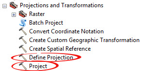
The tools are the Define Projection and Project tools.

In a nut shell...
Define Projection: This tool overwrites the coordinate system information in a dataset
This means only use the Define Projection tool on a dataset that has no coordinate system applied or to a dataset you know for certain has the wrong projection.
Project: This tool projects a dataset from one coordinate system to another through transformation or conversion
Use the Project tool when you want to convert a dataset from one coordinate system to another. For example when converting from ED_50_UTM_31N to ED_50_UTM_30N or when transforming between ED_50_UTM_31N and WGS84_UTM_31N
For more information check out these resources...
Have a look at a related course to learn more on managing and working with coordinate reference systems with ArcGIS:
You must be a registered user to add a comment. If you've already registered, sign in. Otherwise, register and sign in.