- Home
- :
- All Communities
- :
- Products
- :
- ArcMap (Retired)
- :
- ArcMap Questions
- :
- 000210: Cannot create output <value>.
- Subscribe to RSS Feed
- Mark Topic as New
- Mark Topic as Read
- Float this Topic for Current User
- Bookmark
- Subscribe
- Mute
- Printer Friendly Page
000210: Cannot create output <value>.
- Mark as New
- Bookmark
- Subscribe
- Mute
- Subscribe to RSS Feed
- Permalink
Problem:
000210: Cannot create output <value>.
Description
The output cannot be created. Potential reasons include data locking, an incorrect path, and limited access rights.
Solution
Confirm that the data is not locked by another user or application and that you have full rights to the workspace being used. Check to make sure that the path to the data is correct (check for typos in the folder path). Try creating the output in a new location.
This problem occurs when trying to run gp tools on shapefile data with m and z values enabled.
The solution I have is posted here:
Andres Castillo@ Jeff Coulson on Jan 10, 2020 3:14 PM
Troubleshooting steps:
Try either of the two workarounds mentioned in this post:
https://community.esri.com/thread/52480
1
Shorten the filename proposed by the function (14 characters) to something much shorter, then it works!
2
directly named the table inside the output table box and I was able to successfully execute the tool
(see Brian Law's post on June 17, 2019 at 04:46 PM
Did not work for me.
export and buffer fail in agp, unless save as .shp with m and z values enabled under a windows directory directly, as opposed to the project’s default gdb.
buffer works for original .shp with m and z values enabled in ArcMap saving within the default file gdb output path.
ArcMap is able to handle this buffer tool with m and z values enabled on the .shp, but not AGP 2.4.2.
export fails in ArcMap for the original .shp with m and z values enabled when converted to file gdb and leaving m and z values on. Same for AGP.
Verified read/write privileges to the network directory the user was trying to write to by simply creating, then deleting a blank text document within the directory.
We also attempted to replicate the workflow on the user’s local machine.
Changed output file gdb location and that did not work either.
No one else is using this project or the data so the layer is not locked.
The path is also correct.
Solution:
Fc to fc tool from ArcMap:
FcNoProject:
Leave environment settings as is with m and z values enabled.
creates an empty gdb fc
When Add to AGP, then run buffer tool, fails.
When export to .shp
Creates the .shp as expected
When Add to AGP, then run buffer tool, fails.
fcNoMNoProject:
Disable M value from environment settings.
creates an empty gdb fc
When export to .shp
Creates the .shp as expected
When Add to AGP, then run buffer tool, fails.
fcNoMNoZNoProject:
Disable M and Z values from environment settings.
Creates the gdb feature class as expected.
But when try to add it to AGP, still mentions:
‘Add data Failed to add data: fcNoMNoZNoProject Invalid spatial reference. [fcNoMNoZNoProject]
When export to .shp
Creates the .shp as expected
When Add to AGP, then run buffer tool, succeeds.
We can replicate this workflow in AGP with the same behavior:
The guaranteed way that it works is to export the original .shp to .shp with m and z values disabled.
Creates the .shp as expected
Run buffer tool, succeeds.
In ArcMap, noticed unknown units in both layer properties, and bottom-right of ArcMap (show screenshots)
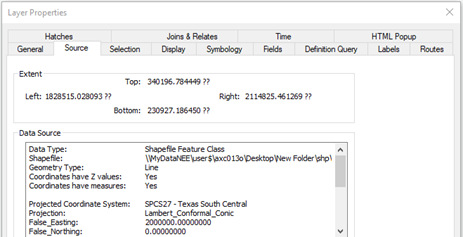
Notice the question marks, denoting unknown units.
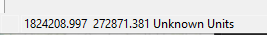
This is the display at the bottom-right of ArcMap.
This ArcGIS idea mentions information regarding the discrepancies between ArcMap 10.4.1 and AGP 2.4.2, as it relates to the shapefile’s coordinate system properties and map display UI Display.
Project tool from ArcMap:
fcProject:
Leave environment settings as is.
creates an empty gdb fc
fcProjectNoM:
Disable M value from environment settings.
creates an empty gdb fc
fcProjectNoMNoZ:
Disable M and Z values from environment settings.
Output coordinate system > Projected coordinate system > State Plane > NAD 1927 (US FEET) > NAD_1927_StatePlane_Texas_South_Central_FIPS_4204
Creates the gdb feature class as expected.
But when try to add it to AGP, still mentions:
‘Add data Failed to add data: fcNoProject Invalid spatial reference. [fcNoProject]
fcProjectNoMNoZGeoTrans:
Disable M and Z values from environment settings.
Creates the feature class as expected.
But when try to add it to AGP, still mentions:
‘Add data Failed to add data: fcProjectNoMNoZGeoTrans Invalid spatial reference. [fcProjectNoMNoZGeoTrans]
We are not able to replicate this ‘projection’ workflow in AGP 2.4.2 because the Project tool does not allow manipulating m and z values in the environment settings.
This ArcGIS idea mentions information regarding the discrepancies between ArcMap 10.4.1 and AGP 2.4.2, as it relates to the Project tool's environment settings:
https://community.esri.com/ideas/17844-project-gp-tool-in-arcgis-pro-242-environment-settings
Summary:
If the input is a shapefile with m and z values enabled, that might interfere with the ability of the gp tools to properly fetch the data.
Note that the gp tool tries to convert to file gdb fc for the output.
Manually remove the gdb output directory, and instead save to a regular windows folder directory to save the output as .shp, without having to DISABLED m and z values.
Another way is to export the .shp to a new .shp without m and z values ENABLED in the environment settings.
You are now able to use this new .shp with any gp tool (fc to fc, export, buffer, etc).
Notes:
It is also practical to stay within the same Desktop Application while working with the data.
For example, if the new .shp that has no m or z values was created from ArcMap, stay in ArcMap.
I say this because I’ve also notice some errors when I start working with data in one application, and then switch to another.
Shapefile are more widespread amongst many gis technologies, other than Esri.
File gdb is more encrypted and compressed, and only Esri technology, so less likely to corrupt when being handed off amongst different people working with the data.
Info regarding Projected and Geographic Coordinate Systems (PCS and GCS, respectfully):
All pcs have gcs, but not vice versa (think parent-child)
pcs is in real-world measurement units (i.e. ft, m)
gcs is in decimal degrees.