- Home
- :
- All Communities
- :
- Products
- :
- ArcGIS Survey123
- :
- ArcGIS Survey123 Blog
- :
- Paper Airplane Day Release (2.8)
Paper Airplane Day Release (2.8)
- Subscribe to RSS Feed
- Mark as New
- Mark as Read
- Bookmark
- Subscribe
- Printer Friendly Page
- Report Inappropriate Content
Do you know the difference between a dart and a glider? Well you should, because you will want to make good use of all those paper forms you no longer need. Get ready for National Paper Airplane Day, which is coming up on May 26!
What goes through your mind while folding a piece of paper to make an airplane? What do you feel when it escapes your fingers gliding away? Paper airplanes are truly amazing. Take a moment to enjoy them, if possible with good company.
We split our 2.8 update in two. Just a few days ago we released the Survey123 field app with a critical fix for all of you using the app with public surveys. We also included a couple of additional bug fixes. For more details refer to thehttps://community.esri.com/groups/survey123/blog/2018/05/16/minor-update-to-the-survey123-field-app-... blog post. Today, we are making available an update to our Survey123 website. It comes with some bug fixes, but also brings a few interesting new features. Here are the highlights:
Survey123 Web Designer Enhancements
Survey123 Web Designer lets you visually build your own surveys, right from your web browser. In this update, we have added features particularly useful for those of you who plan to publish surveys for exclusive use from web browsers (Web Forms).
New Single Choice Grid questions: Survey123 web designer now includes a new type of question called Single Choice Grid. This question type lets you to arrange a set of single choice questions in a table. The only condition is that all single choice questions in the table use of the same choice list.
There are multiple scenarios where Single Choice Grids are useful. A classic one is checklists, like the one presented below for a Fire Safety inspection.
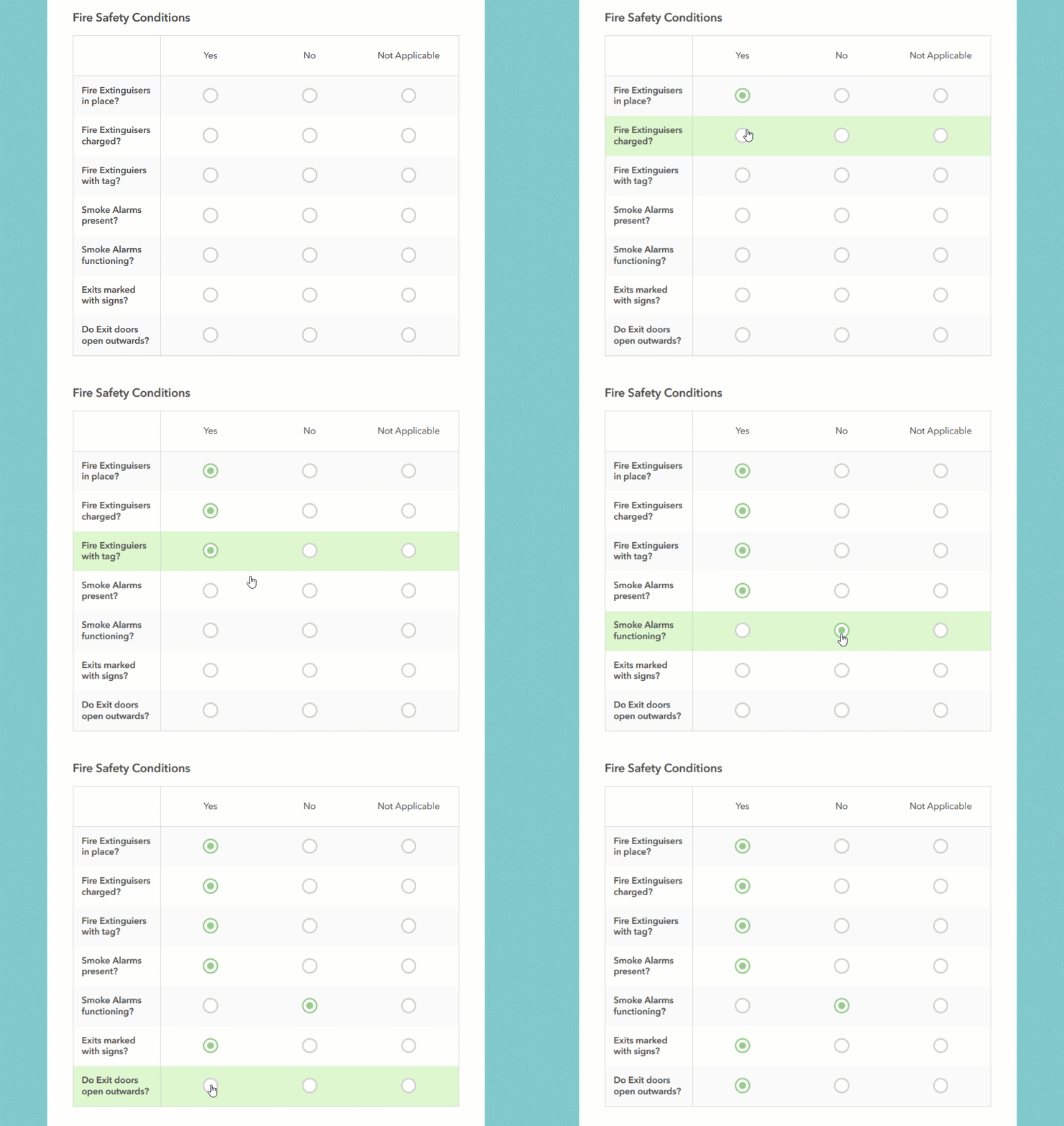
Single Choice Grids will help you compact questions within your forms allowing users to enter data more easily. As you add Single Choice Grid questions into your form, keep in mind the following:
- Horizontal real estate is going to be limited, so keep the number of choices in your lists and labels short.
- You cannot set rules against the Single Choice Grid or any of the individual questions in it.
- If you choose to flag the grid as required, then all rows (questions) within the grid must contain an answer.
- Single Choice Grids are only supported in Web Forms (in our Survey123 Web App). The Survey123 Field app does not currently handle this type of question. [Updated Sep 26, 2019] As of version 3.6, the field app also supports single choice grids.
Custom Thank You Notes: Thank You notes are presented right after a survey is submitted from a Web Form (from the Survey123 Web App). It is good practice to control the text presented in this dialog. This is of course the right place to thank respondents for taking time to complete your survey, but also a great place to acknowledge sponsors of your project or direct respondents to your website, next actions etc.
Starting with this update, we added a rich text editor widget so you can better control the look and feel of your Thank You notes. You can add links, images, define the size and color of text and more.
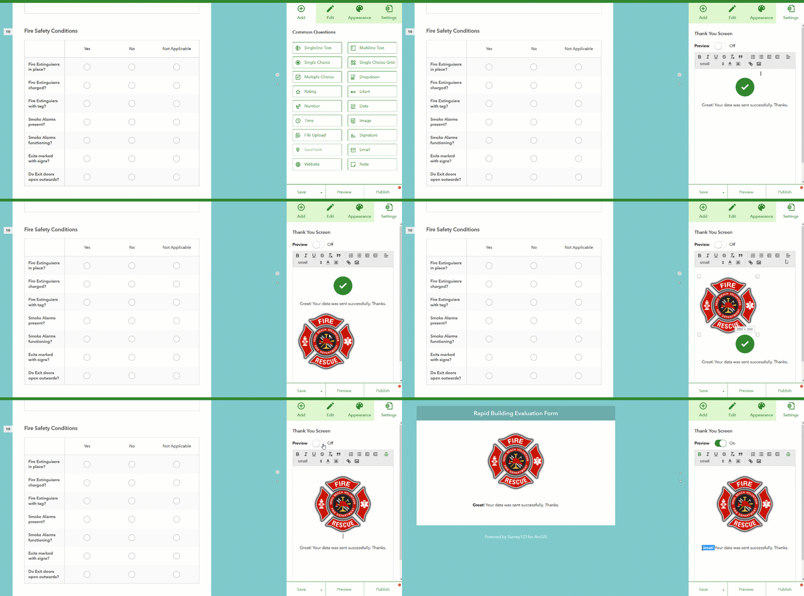
From within Web Designer you will be able to preview your Thank You note and also control if a link should be included to allow respondents to submit the survey again.
Geosearch for Geopoint questions at design time: Through the new geosearch widget included in geopoint questions, you can now more easily set the initial extent and zoom level of your map. This is particularly relevant for online surveys where people will submit data through a Web Form. When your survey is open from a web browser, you cannot assume that the map will be centered automatically at the user's location, because often location services are disabled in browsers for privacy reasons. With this new geosearch widget there is really no excuse for you to leave an initial map extent that is not relevant to your project!
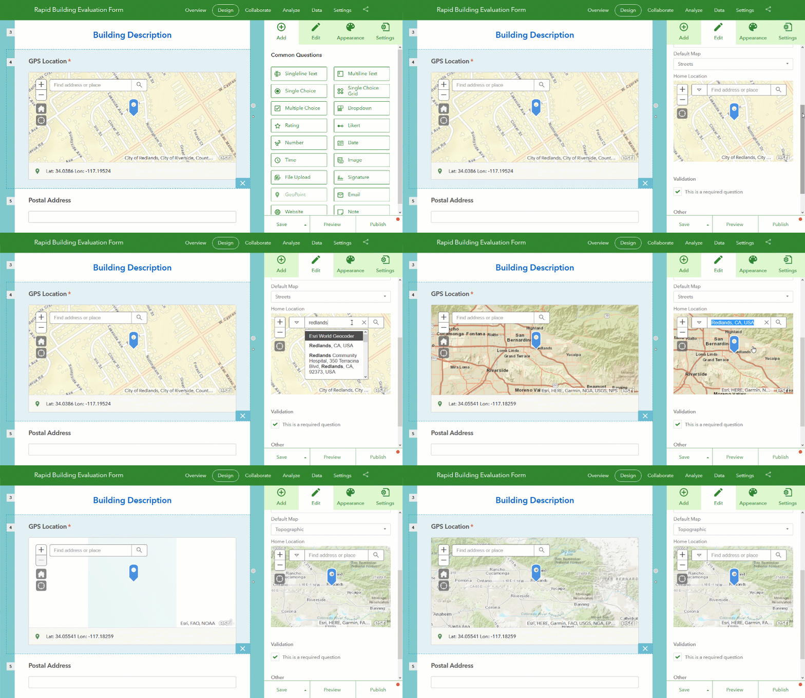
Note: The geosearch widget uses the default locator configured in your ArcGIS Online organization.
Survey Collaborate Tab
Through the Collaborate tab in the Survey123 website, you control who can submit data to your surveys, and who can view their results.
Restrict Viewer Access: Through the Viewer category in the Collaborate tab, you define which Groups within your ArcGIS organization can visualize the results of your survey. We have added a new option that lets you control if access to the survey results is restricted to survey entries submitted by the logged-in user, or all results in the survey.
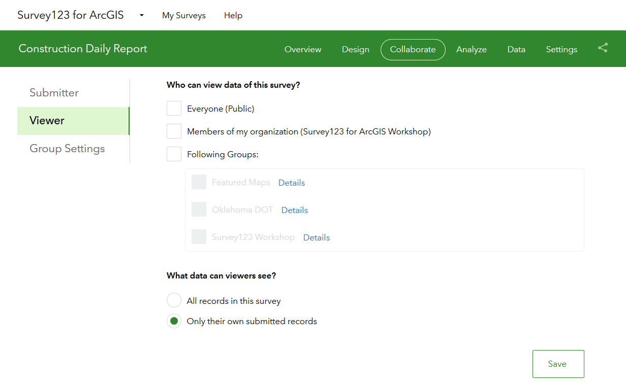
As the owner of a survey, this option gives you tighter control over what data can people see in your surveys. Here is a scenario where this new option will be handy: Pretend that you have published a survey for a group of Building Inspectors. Through Collaborate/Submitter you have already granted them access to your survey, so all Building Inspectors are happily submitting their work to you. Next, you would also like Building Inspectors to have access to their own submitted data through the Survey123 website. Through Collaborate/Viewer you will next grant the Inspectors Group with access to the results of the survey, but since you do not want inspectors to see someone else's work, you will grant visibility to 'Only their own submitted records'. At that moment, inspectors can log into the Survey123 website and access their own records. For example, they can use the Data tab in the Survey123 website to export all their inspection data into Excel, generate high quality printable reports of their inspection records or even look at trends across their own inspections through the Analyze tab. Administrators of the ArcGIS organization and owners of the survey will always have access to all records.
Shortened survey URL links (ArcGIS Online only): If working against ArcGIS Online, the next time you share a survey URL with someone or include it into a website or e-mail, you will note that the Survey123 website will shorten them for you. The animation below shows the difference between the shortened and original URLs.

We feel like shortened URLs are easier for most people, but if you are a nostalgic, purist or you simply want the original URL, all you need to do is to copy the shortened URL into a web browser and navigate to it. You will see that the shortened URL is simply a shortcut that gets redirected to the source (and long) URL of your survey.
Survey Analyze and Data Tabs
Photo Galleries in the Analyze report: Up until now, Image and Signature questions in your survey were not included in the Analyze report. Starting with this update, photo galleries will be used to display data submitted into Image and Signature questions.
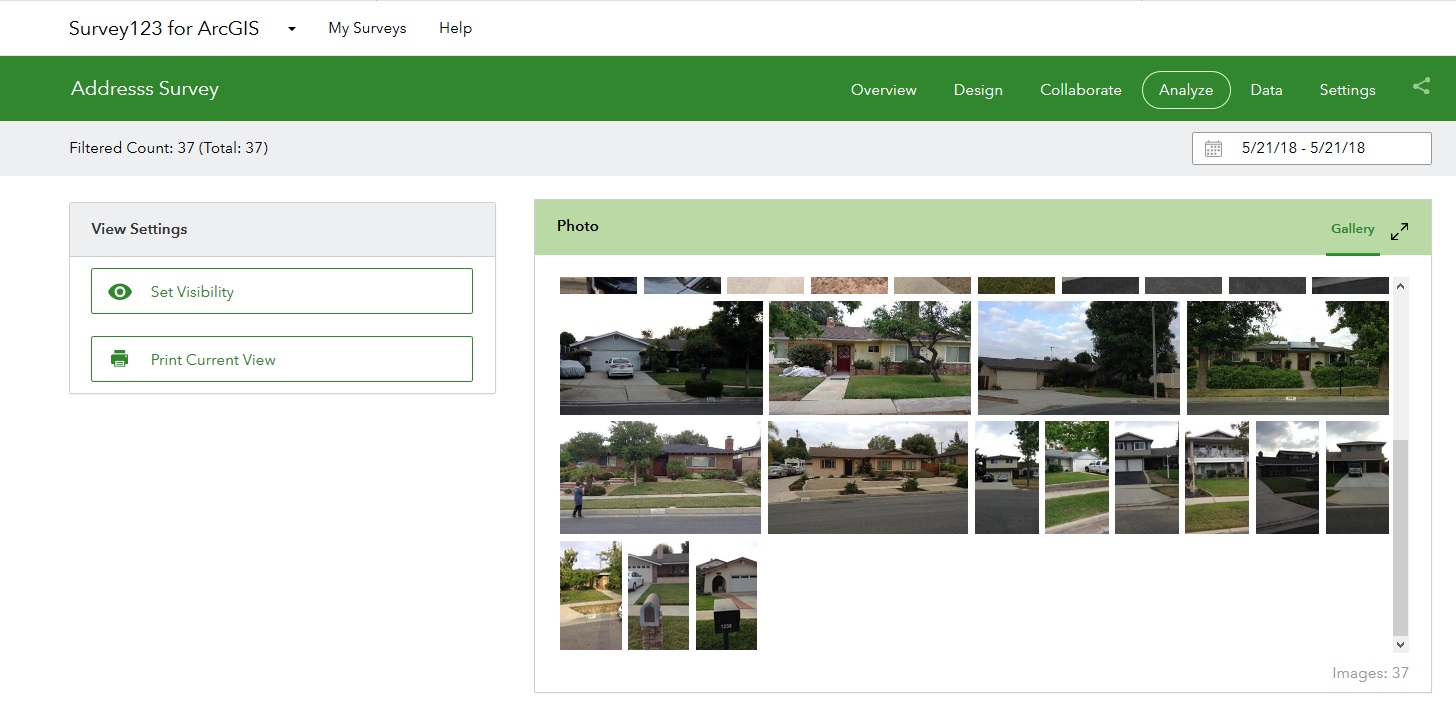
The new galleries will let you more quickly scan large collections of photos submitted to your survey and if needed, by clicking on them, get more details on the photo itself.
Sort surveys by date in the Data tab table: The Data tab shows your survey results as a map and a table. Some of you suggested that data in the table should show the newest surveys on top by default. We think this is a good idea too, so rows are now sorted by the Edit Date column, in descending order. If you would like to sort using a different column, all you need to do is to click on the column header and set your sorting preference.
Barcode question support in Individual Response reports (Data tab): The individual response report shown when you select a record from the survey table now supports Barcode questions as well, which are treated similarly to Text questions.
Survey Gallery
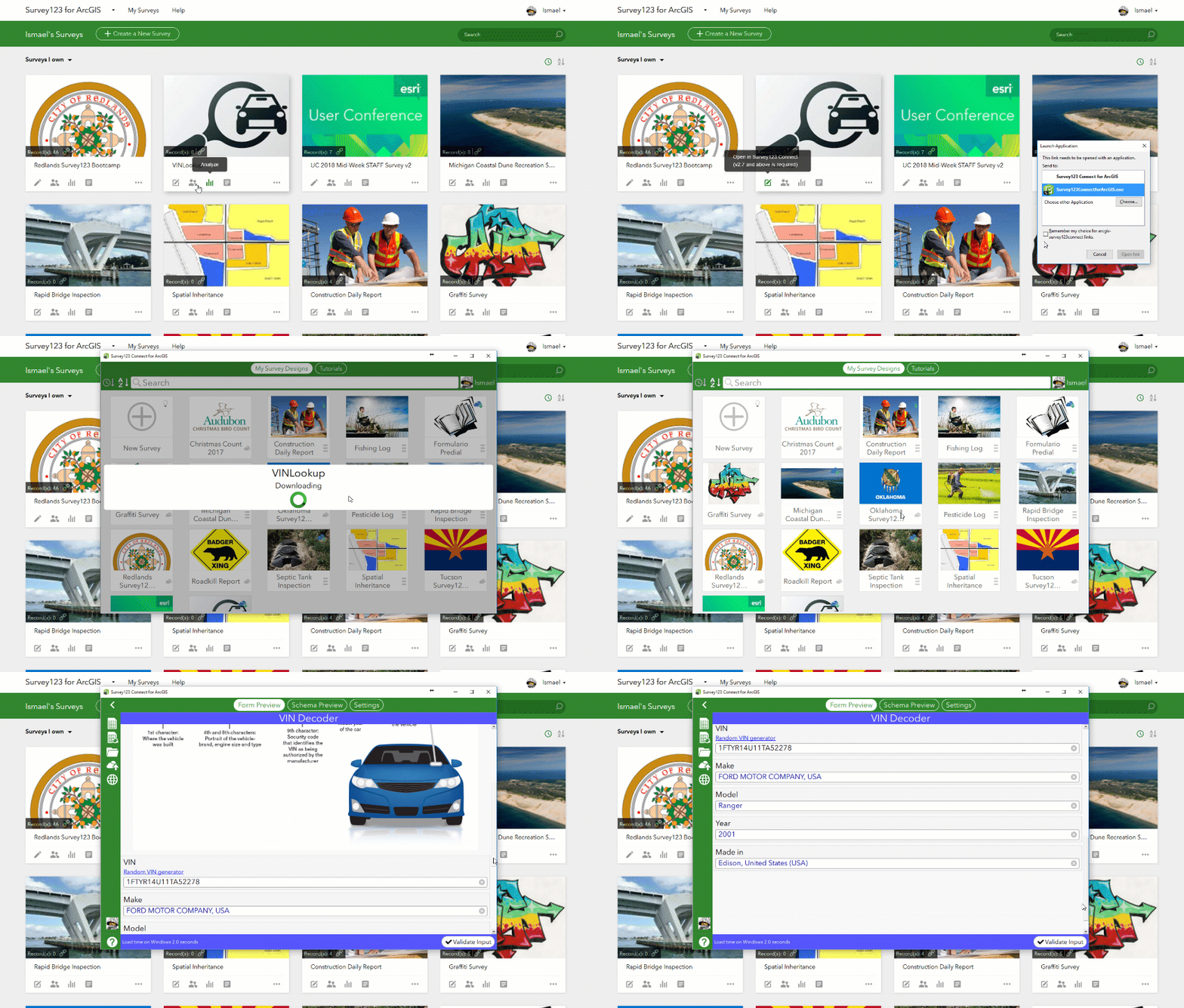
Launch Connect directly from the survey gallery: You can now easily launch Survey123 Connect from the survey gallery to make updates and re-publish your Connect surveys. This option will only work if you have Survey123 Connect 2.7 or newer. I trust you will have Connect in its latest release. Right? You would actually not believe how many people out there are still running 1.x versions of Connect! ![]()
Major Bug Fixes and Enhancements
Survey123 Web Form (aka Survey123 Web App):
- BUG-000108086 Field values are missing in questions within repeats (Web Form)
- BUG-000109787 Pulldata caculations within a repeat do not update note questions if the survey is open from a web browser.
- BUG-000108785 The message "Surveys published by Survey123 Connect for ArcGIS are currently not supported" appears when attempting to open a survey published with Connect from a web browser, if the hosting portal is configured with Integrated Windows Authentication.
Survey123 website:
- BUG-000113180 Unable to share a survey with a group when the user is a group manager of that group in ArcGIS Online and the group setting 'who can contribute' is set to 'Only group owner and managers'
- BUG-000113270 With Portal 10.5.1 configured with IWA, surveys published using Survey123 Connect do not show data for users in https://survey123.arcgis.com
- BUG-000113054 The data tab of the survey123.arcgis.com website does not have appropriate logic to prevent attempting to export data that comes directly from ArcGIS Server
- BUG-000107294 Incorrect German translation of "Please input a number less than xx".
- BUG-000113741 When deleting a survey that is created from an existing feature service in Portal for ArcGIS, the behavior is different between Survey123 Connect for ArcGIS and the Survey123 for ArcGIS website
- Static content in the Survey123 web site is delivered leveraging Content Delivery Network Services to reduce loading times. This will be particularly noticeable outside the United States.
Survey123 field app and Connect:
- Regression on Public Surveys: Our 2.7 release introduced an issue that prevented the use of Public Surveys if no user was logged into the Survey123 field app. This is now addressed, allowing the use of Public Surveys in the field app even if there is no user logged-in. Thanks to all of you who promptly reported this problem and helped diagnose it through this GeoNet Group.
- Check for offline conditions on Windows: This update includes a fix that enhances Survey123's ability to detect if your device is connected or not, when working on Windows. We have observed some reports of Survey123 on Windows not detecting offline conditions when working on very specific network configurations. The offline check is much better now.
- BUG-000107663 Features do not display in webmap after submission by the field app: Some of you have reported that ArcGIS Online Web Maps with a refresh interval set, were not automatically showing new features added from the Survey123 field app. The problem was caused by a combination of issues in both ArcGIS Online feature services and the Survey123 field app. All problems are solved now!
An Archive of What's new in Survey123—Survey123 for ArcGIS | ArcGIS is available in our product help documentation.
Beyond 2.8
Our next major release will be 3.0, which we envision shipping around July 2018. If needed, we may squeeze in 2.9 as a maintenance release with critical fixes. Here is what we are planning for our next updates:
- Custom Form Reports: Our Leveraging Custom Form Report Templates in Survey123 for ArcGIS blog post anticipated this feature, which is currently available to all of you in Beta. We are working hard to move this feature into general release and incorporate into it bulk report capabilities.
- Support for nested repeats: This feature is available for testing already through our Early Adopter Program and allows you to author surveys that have repeats within repeats. This will be part of our 3.0 release in July.
- Enhanced support for external GNSS receivers: At the moment, you can use external GNSS receivers with Survey123, but only in a limited way. For example, you cannot extract key metadata from the receiver such as VDOP, HDOP, Number of Satellites or the Fix Type... With the 3.0 update our intent is to extend the pulldata() function so you can also extract this important metadata and store it along with the features you capture. We also plan to provide support for RTK corrections. We are working towards having this feature available for testing in our Early Adopter Program around June around July, but will not be part of 3.0.
- Webhook integration: An earlier post Sneak Peek: Survey123 and Webhooks (Integromat) described this work in more detail. Available for testing today through the Early Adopter Program. Planned for our 3.0 release.
- GeoSearch in the Survey123 field app map widget: Check out this video in our Early Adopter Program for details. Available for testing now and planned to be part of 3.0.
- Support for Web Maps, Vector Tiles and Mobile Map Packages: This is a big deal as it will make maps for geopoint questions much better looking, useful and lightweight. Looking at having this available for testing around June. Postponed until later in 2018.
- Pages: While Pages are not officially supported yet, we continue working on improving this feature. Starting with 2.7 you will notice that the page navigation has been vastly improved, although there are multiple areas that still need more work before we can call it 'ready'. If you are into pages, do not hesitate providing your feedback via the Beta forum in our Early Adopter Program.
- Portal support: As of version 3.0 of Survey123 for ArcGIS, we will no longer support working against version 10.3.1 or older of Portal for ArcGIS.
- iOS support: Following Apple's announcement regarding end of support for 32 bit devices starting with iOS 11, our 3.0 release will also drop support for 32 bit devices. Having said this, we understand that many of you still have not, or don't plan to upgrade your Apple devices in the short term. Therefore we will make available a 32bit compatible version of Survey123 in the Apple store for a period of time to assist you with your transition. We will be naming this 32-bit compatible version of the app, Survey123 Classic and it will include only 2.8 functionality.
- Android support: The minimum version of the Android operating system with Survey123 3.0 will be 4.4. The Classic flavor of Survey123 will support Android back to 4.1, but will only include 2.8 functionality.
A lot in the plate as you can see for 3.0. Our focus however it is not going to deviate from listening carefully to all your feedback through this GeoNet Group, so keep your questions and suggestions coming!
You must be a registered user to add a comment. If you've already registered, sign in. Otherwise, register and sign in.