Turn on suggestions
Auto-suggest helps you quickly narrow down your search results by suggesting possible matches as you type.
Cancel
- Home
- :
- All Communities
- :
- Products
- :
- ArcGIS Spatial Analyst
- :
- ArcGIS Spatial Analyst Questions
- :
- Least Cost Path Anomalies
Options
- Subscribe to RSS Feed
- Mark Topic as New
- Mark Topic as Read
- Float this Topic for Current User
- Bookmark
- Subscribe
- Mute
- Printer Friendly Page
Least Cost Path Anomalies
Subscribe
1627
0
09-14-2011 06:52 AM
09-14-2011
06:52 AM
- Mark as New
- Bookmark
- Subscribe
- Mute
- Subscribe to RSS Feed
- Permalink
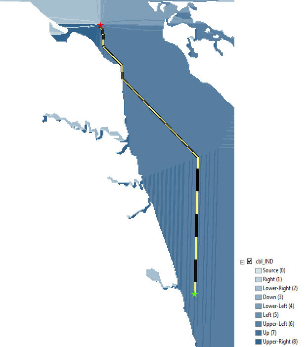
I have been running some least cost path analyses on manatee GPS telemetry data using ArcGIS 9.3.1. The goal of this analysis is to create the shortest path between points without the path crossing land. We have tried using a simple cost surface (with water given a low cost and land either given a high cost or set as no data), but we have found the results to be unsatisfactory. The final paths often zigzag through an open water body, rather than taking a straight line path. I have done some testing and have traced these anomalies to the cost backlink raster, which appears to have what I am calling �??chutes�?� where the path is forced to travel north-south or east-west for some distance. This action skews the final path and results in a longer path than expected. I have attached an image that represents the final path and the backlink raster used to create the path.
Additionally, we have tested more complicated or heterogeneous cost surfaces based on bathymetry layers to compare the results. What we have found is that the more complicated the cost surface is, the less dependent the final path is on the backlink raster. For our objective, a simple cost surface is the most appropriate.
Has anyone experienced similar problems using the least cost path? I appreciate any suggestions you may have for working around this problem.
0 Replies