Turn on suggestions
Auto-suggest helps you quickly narrow down your search results by suggesting possible matches as you type.
Cancel
- Home
- :
- All Communities
- :
- Products
- :
- ArcGIS Spatial Analyst
- :
- ArcGIS Spatial Analyst Questions
- :
- How to sum raster cells until a threshhold value i...
Options
- Subscribe to RSS Feed
- Mark Topic as New
- Mark Topic as Read
- Float this Topic for Current User
- Bookmark
- Subscribe
- Mute
- Printer Friendly Page
How to sum raster cells until a threshhold value is met?
Subscribe
422
0
12-15-2010 01:29 PM
12-15-2010
01:29 PM
- Mark as New
- Bookmark
- Subscribe
- Mute
- Subscribe to RSS Feed
- Permalink
- Report Inappropriate Content
Hello-
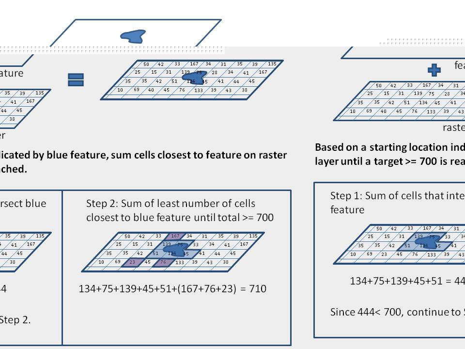
I'm relatively new to working with rasters, and am having a hard time figuring out how calculate an optimal area based on two datasets. Basically, I have two layers, one is a feature, the other a raster. I'd like to find the sum of all cells in the raster layer that intersect that feature object, and then start summing the adjacent raster cells, expanding outwards as necessary, until the sum of those cells is equal to or greater than a specified threshhold value that I decide. All this should be accomplished using the least number of cells possible that are still adjacent to one another (either side-by-side, or by corners). In the end, I'd like to have the final summation value, and be able to make a polygon of the cells used to get that total. I think that some of what I want to do is very similar in concept to the least-cost path distance, but I don't know how to apply this for an areal analysis. I've included an image to help explain what I'm trying to do.
I'm not sure if this is something relatively easy to do and I've just been searching using the wrong terms, or if its a bit more tricky than that. Any suggestions would be very welcome! Thanks!
0 Replies