Turn on suggestions
Auto-suggest helps you quickly narrow down your search results by suggesting possible matches as you type.
Cancel
- Home
- :
- All Communities
- :
- Products
- :
- Data Management
- :
- Data Management Questions
- :
- Best way to d display OS Data OS VectorMap Distri...
Options
- Subscribe to RSS Feed
- Mark Topic as New
- Mark Topic as Read
- Float this Topic for Current User
- Bookmark
- Subscribe
- Mute
- Printer Friendly Page
Best way to d display OS Data OS VectorMap District and OS Street View in ESRI 9.3.1
Subscribe
967
1
06-28-2014 08:36 AM
06-28-2014
08:36 AM
- Mark as New
- Bookmark
- Subscribe
- Mute
- Subscribe to RSS Feed
- Permalink
- Report Inappropriate Content
Hi,
I am trying to display the open source OS data for Vector District (http://www.ordnancesurvey.co.uk/business-and-government/products/vectormap-district.html) and OS Street View (http://www.ordnancesurvey.co.uk/business-and-government/products/os-streetview.html). Of course it would be easy in 10.x, but I am limited to 9.3.1. I need to be able to display this raster data on a machine that is not connected to the internet. I think mosiacing the data is a bit too difficult it takes too long and its very large. So I am currently populating a Raster Catalog in a File GeoDatabase. This is taking a very long time, so far over a day. I am not even sure its going to work. To do this with OS Street View will take even longer. So am I wasting my time in trying to do any type of optimisation?
Many thanks
Tuckers
1 Reply
06-30-2014
01:30 PM
- Mark as New
- Bookmark
- Subscribe
- Mute
- Subscribe to RSS Feed
- Permalink
- Report Inappropriate Content
Hi Tuckers,
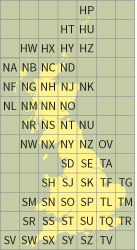
I've worked quite a bit with the OS Street View and OS Vector District data. I have relied on Mosaic datasets for the OS Street View data and I found it very easy to do with mosaic datasets. You should be able to put it into a Raster Catalog, but if you are using a different projection for the dataframe be sure to use the Petroleum Transformation.
I would say that you are not wasting your time, just it would be much easier with ArcGIS 10 and mosaic datasets. You might want to mosaic the images first to meet the National Grid Reference Squares, this would give you less images to add to the Raster Catalog. It would be fairly easy to set up a model to do this.
[ATTACH=CONFIG]35000[/ATTACH]
Thanks,
Arthur Crawford