Turn on suggestions
Auto-suggest helps you quickly narrow down your search results by suggesting possible matches as you type.
Cancel
- Home
- :
- All Communities
- :
- Developers
- :
- Native Maps SDKs
- :
- Runtime SDK for iOS Questions
- :
- Add Point Feature - Not adding Geometry
Options
- Subscribe to RSS Feed
- Mark Topic as New
- Mark Topic as Read
- Float this Topic for Current User
- Bookmark
- Subscribe
- Mute
- Printer Friendly Page
Add Point Feature - Not adding Geometry
Subscribe
1572
7
09-19-2011 01:29 PM
09-19-2011
01:29 PM
- Mark as New
- Bookmark
- Subscribe
- Mute
- Subscribe to RSS Feed
- Permalink
Hi
I'm attempting to use the FeatureEditingSample codebase to add a point feature to my map.
(I changed the code to not use a WebMap, but rather a Feature Service).
The code is executing, and a new record with an ObjectID all of the attributes are being posted to ArcSDE, but there is no geometry associated with it, so the point won't display on the map, of course.
Is there something special I have to do when working with a Point Feature Class when using the FeatureEditing Code Sample?
7 Replies
09-19-2011
01:57 PM
- Mark as New
- Bookmark
- Subscribe
- Mute
- Subscribe to RSS Feed
- Permalink
Update on what's happening.
After I click 'Sketch Done', the sketch disappears, but the Feature Symbology (From the template) does not show up.
I'm getting no errors, and stepping through the code, it seems that everything is happening as it should.
😞
After I click 'Sketch Done', the sketch disappears, but the Feature Symbology (From the template) does not show up.
I'm getting no errors, and stepping through the code, it seems that everything is happening as it should.
😞
09-20-2011
12:13 AM
- Mark as New
- Bookmark
- Subscribe
- Mute
- Subscribe to RSS Feed
- Permalink
hi i am not sure if we are on the same issue
inside featuretemplatepickerviewcontroller there is - addtemplatesfromlayer
- (void) addTemplatesFromLayer:(AGSFeatureLayer*)layer {
NSLog(@"addTemplatesFromLayer at : %@",layer);
i load a layer inside from FeatureLayerEditingSampleViewController.m
[self.featureTemplatePickerViewController addTemplatesFromLayer:self.OnOffLineLayer];
and wala.. i got the feature type.
09-20-2011
12:34 AM
- Mark as New
- Bookmark
- Subscribe
- Mute
- Subscribe to RSS Feed
- Permalink
hi i am not sure if we are on the same issue
inside featuretemplatepickerviewcontroller there is - addtemplatesfromlayer
- (void) addTemplatesFromLayer:(AGSFeatureLayer*)layer {
NSLog(@"addTemplatesFromLayer at : %@",layer);
i load a layer inside from FeatureLayerEditingSampleViewController.m
[self.featureTemplatePickerViewController addTemplatesFromLayer:self.OnOffLineLayer];
and wala.. i got the feature type.
inside featuretemplatepickerviewcontroller there is - addtemplatesfromlayer
- (void) addTemplatesFromLayer:(AGSFeatureLayer*)layer {
NSLog(@"addTemplatesFromLayer at : %@",layer);
i load a layer inside from FeatureLayerEditingSampleViewController.m
[self.featureTemplatePickerViewController addTemplatesFromLayer:self.OnOffLineLayer];
and wala.. i got the feature type.
09-20-2011
07:59 AM
- Mark as New
- Bookmark
- Subscribe
- Mute
- Subscribe to RSS Feed
- Permalink
Darren,
What is the spatial reference of your feature layer?
What is the spatial reference of your map (mapView)?
In which spatial reference you are creating new geometries?
You should create new geometries in the map's spatial reference so it can be displayed at correct location. When you post your edits to server, server will take care of converting it to feature layer's spatial reference.
Hope this helps!
Regards,
Nimesh
09-26-2011
12:25 PM
- Mark as New
- Bookmark
- Subscribe
- Mute
- Subscribe to RSS Feed
- Permalink
Hi Nimesh
Spatial Feature of the FService is : 2249
The spatial ref of my mapview is the same (2249).
The process runs, no errors are thrown. However, the feature with its symbology don't show in my map as it does in the example and when I open the Feature Class in SDE and I see the attributes, but there is no geometry.
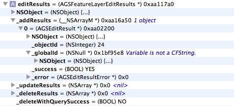
I've attached the editresults during debug.
Also, I'm using my own map service not webmap.
AGSMapServiceInfo *bms = [[[AGSMapServiceInfo alloc] initWithURL:[NSURL URLWithString:baseLayerURL] error:&error] autorelease];
AGSDynamicMapServiceLayer *baseLayer = [[AGSDynamicMapServiceLayer alloc] initWithMapServiceInfo:bms];
also at didSelectFeatureTemplate
//set the active feature layer to the one we are going to edit
self.activeFeatureLayer = featureLayer;
//create a new feature based on the template
_newFeature = [self.activeFeatureLayer createFeatureWithTemplate:template];
[self.activeFeatureLayer addGraphic:_newFeature];
AGSGraphic *gr = _newFeature;
self.popupInfo = [AGSPopupInfo popupInfoForGraphic: gr];
self.popupInfo.allowEditGeometry = YES;
self.popupInfo.showAttachments = YES;
//Filter the fields we want to display to the user
NSMutableArray* fieldInfos = [self.popupInfo.fieldInfos mutableCopy];
NSMutableArray* displayFields = [[[NSMutableArray alloc] init] autorelease];
NSArray* inspectiondisplayeditfields = [[[NSArray alloc] init] autorelease];
inspectiondisplayeditfields = self.fieldsForEditing;
for (AGSPopupFieldInfo* fieldInfo in fieldInfos) {
for (int i = 0 ; i < [inspectiondisplayeditfields count] ; i++) {
if ([fieldInfo.fieldName isEqualToString:[inspectiondisplayeditfields objectAtIndex:i]])
{
[displayFields addObject:fieldInfo];
}
}
}
self.popupInfo.fieldInfos = displayFields;
//Show popup for the graphic because the user tapped on the callout accessory button
self.popupVC = [[[AGSPopupsContainerViewController alloc] initWithPopupInfo:_popupInfo graphic:gr usingNavigationControllerStack:NO] autorelease];
self.popupVC.delegate = self;
self.popupVC.modalTransitionStyle = UIModalTransitionStyleFlipHorizontal;
//If iPad, use a modal presentation style
if([[UIDevice currentDevice] isIPad])
self.popupVC.modalPresentationStyle = UIModalPresentationFormSheet;
// //First, dismiss the Feature Template Picker
[self dismissModalViewControllerAnimated:NO];
[self presentModalViewController:self.popupVC animated:YES];
[self.popupVC startEditingCurrentPopup];
[fieldInfos release];
Spatial Feature of the FService is : 2249
The spatial ref of my mapview is the same (2249).
The process runs, no errors are thrown. However, the feature with its symbology don't show in my map as it does in the example and when I open the Feature Class in SDE and I see the attributes, but there is no geometry.
I've attached the editresults during debug.
Also, I'm using my own map service not webmap.
AGSMapServiceInfo *bms = [[[AGSMapServiceInfo alloc] initWithURL:[NSURL URLWithString:baseLayerURL] error:&error] autorelease];
AGSDynamicMapServiceLayer *baseLayer = [[AGSDynamicMapServiceLayer alloc] initWithMapServiceInfo:bms];
also at didSelectFeatureTemplate
//set the active feature layer to the one we are going to edit
self.activeFeatureLayer = featureLayer;
//create a new feature based on the template
_newFeature = [self.activeFeatureLayer createFeatureWithTemplate:template];
[self.activeFeatureLayer addGraphic:_newFeature];
AGSGraphic *gr = _newFeature;
self.popupInfo = [AGSPopupInfo popupInfoForGraphic: gr];
self.popupInfo.allowEditGeometry = YES;
self.popupInfo.showAttachments = YES;
//Filter the fields we want to display to the user
NSMutableArray* fieldInfos = [self.popupInfo.fieldInfos mutableCopy];
NSMutableArray* displayFields = [[[NSMutableArray alloc] init] autorelease];
NSArray* inspectiondisplayeditfields = [[[NSArray alloc] init] autorelease];
inspectiondisplayeditfields = self.fieldsForEditing;
for (AGSPopupFieldInfo* fieldInfo in fieldInfos) {
for (int i = 0 ; i < [inspectiondisplayeditfields count] ; i++) {
if ([fieldInfo.fieldName isEqualToString:[inspectiondisplayeditfields objectAtIndex:i]])
{
[displayFields addObject:fieldInfo];
}
}
}
self.popupInfo.fieldInfos = displayFields;
//Show popup for the graphic because the user tapped on the callout accessory button
self.popupVC = [[[AGSPopupsContainerViewController alloc] initWithPopupInfo:_popupInfo graphic:gr usingNavigationControllerStack:NO] autorelease];
self.popupVC.delegate = self;
self.popupVC.modalTransitionStyle = UIModalTransitionStyleFlipHorizontal;
//If iPad, use a modal presentation style
if([[UIDevice currentDevice] isIPad])
self.popupVC.modalPresentationStyle = UIModalPresentationFormSheet;
// //First, dismiss the Feature Template Picker
[self dismissModalViewControllerAnimated:NO];
[self presentModalViewController:self.popupVC animated:YES];
[self.popupVC startEditingCurrentPopup];
[fieldInfos release];
09-26-2011
02:22 PM
- Mark as New
- Bookmark
- Subscribe
- Mute
- Subscribe to RSS Feed
- Permalink
Is graphic/feature has valid geometry before sending it to server?
If you're geometry is not in either WGS 1984 or Web Mercator spatial references then you must comment out following code line from sample.
popup.graphic.geometry = [[AGSGeometryEngine defaultGeometryEngine]normalizeCentralMeridianOfGeometry:popup.graphic.geometry];
Regards,
Nimesh
If you're geometry is not in either WGS 1984 or Web Mercator spatial references then you must comment out following code line from sample.
popup.graphic.geometry = [[AGSGeometryEngine defaultGeometryEngine]normalizeCentralMeridianOfGeometry:popup.graphic.geometry];
Regards,
Nimesh
09-27-2011
04:36 AM
- Mark as New
- Bookmark
- Subscribe
- Mute
- Subscribe to RSS Feed
- Permalink
Thanks Nimesh - That was the issue!!!